
Ficheiro:Northern Mali conflict.svg

Dimensões desta antevisão em PNG do ficheiro SVG: 629 × 600 píxeis Outras resoluções: 252 × 240 píxeis | 503 × 480 píxeis | 805 × 768 píxeis | 1 074 × 1 024 píxeis | 2 148 × 2 048 píxeis | 1 316 × 1 255 píxeis.
Imagem numa resolução maior (ficheiro SVG, de 1 316 × 1 255 píxeis, tamanho: 796 kB)
|
|
Esta imagem provém do Wikimedia Commons, um acervo de conteúdo livre da Wikimedia Foundation que pode ser utilizado por outros projetos.
|
Descrição do ficheiro
| Descrição |
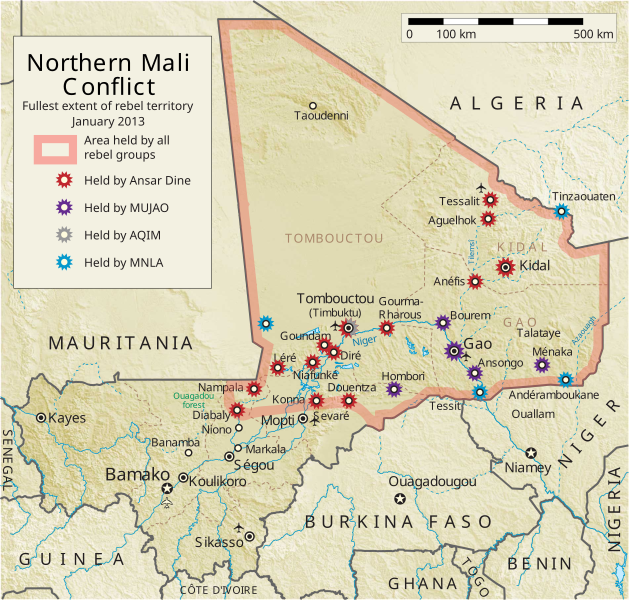
English: Map of the conflict in Northern Mali. (English)
العربية: خريطة الصّراع في شمال مالي. (إنجليزي)
Français : Carte du conflit au nord du Mali. (Anglais)
Latina: Charta rebellionis Tuaregorum in Malia septentrionali. (Anglice)
Українська: Карта конфлікту на півночі Малі. (Англійською) |
| Origem |
Obra do próprio Este desenho vetorial inclui elementos que foram usados ou adaptados de: Este desenho vetorial inclui elementos que foram usados ou adaptados de: |
| Autor | Orionist |
| Outras versões | German/Deutsch/Allemand, French/Français, Macedonian/македонски јазик/Macédonien |
| SVG desenvolvimento | Esta carta geográfica inválida foi criada com o Adobe Illustrator, e com o Inkscape. Esta carta geográfica SVG utiliza texto incorporado que pode ser facilmente traduzido usando um editor de texto. |
Notes
- ↑ US Department of State, "Country Reports on Terrorism 2011", Chapter 2 Country Reports: Africa Overview, 31 July 2012
Licenciamento
Eu, titular dos direitos de autor desta obra, publico-a com a seguinte licença:
A utilização deste ficheiro é regulada nos termos da licença Creative Commons - Atribuição-CompartilhaIgual 3.0 Não Adaptada.
- Pode:
- partilhar – copiar, distribuir e transmitir a obra
- recombinar – criar obras derivadas
- De acordo com as seguintes condições:
- atribuição – Tem de fazer a devida atribuição da autoria, fornecer uma hiperligação para a licença e indicar se foram feitas alterações. Pode fazê-lo de qualquer forma razoável, mas não de forma a sugerir que o licenciador o apoia ou subscreve o seu uso da obra.
- partilha nos termos da mesma licença – Se remisturar, transformar ou ampliar o conteúdo, tem de distribuir as suas contribuições com a mesma licença ou uma licença compatível com a original.
Histórico do ficheiro
Clique uma data e hora para ver o ficheiro tal como ele se encontrava nessa altura.
| Data e hora | Miniatura | Dimensões | Utilizador | Comentário | |
|---|---|---|---|---|---|
| atual | 06h59min de 8 de abril de 2014 | | 1 316 × 1 255 (796 kB) | Ansh666 | Reverted to version as of 16:51, 8 March 2013 - restoring the correct version, as the map is supposed to be historical, not current |
| 20h15min de 5 de dezembro de 2013 |  | 1 316 × 1 255 (699 kB) | Hanibal911 | more accurately reflects the situation | |
| 16h51min de 8 de março de 2013 |  | 1 316 × 1 255 (796 kB) | Agricolae | Hombori dot restored | |
| 14h29min de 5 de março de 2013 |  | 1 316 × 1 255 (794 kB) | TUFKAAP | Since this is an English map, Al-Qaeda in the Islamic Maghreb should be abbreviated as AQIM. | |
| 03h33min de 11 de fevereiro de 2013 |  | 1 316 × 1 255 (794 kB) | Agricolae | shift text distorted on upload | |
| 03h27min de 11 de fevereiro de 2013 |  | 1 316 × 1 255 (794 kB) | Agricolae | change to show greatest extent - see WP Talk:Northern Mali conflict (2012–present) | |
| 06h36min de 8 de fevereiro de 2013 |  | 1 316 × 1 255 (699 kB) | Rama | Aguelhok contested or taken ( http://www.lemonde.fr/afrique/article/2013/02/08/mali-les-forces-francaise-et-tchadiennes-a-aguelhok_1828906_3212.html ) | |
| 10h29min de 2 de fevereiro de 2013 |  | 1 316 × 1 255 (698 kB) | U5K0 | Bourem to green as per talk page | |
| 08h41min de 30 de janeiro de 2013 |  | 1 316 × 1 255 (679 kB) | Orionist | Updated map: Menaka, Anderamboukane, Ansongo, Dire, Kidal and other MNLA positions. Removed rebel area boundaries as the situation has become complicated. | |
| 17h23min de 29 de janeiro de 2013 |  | 1 316 × 1 255 (894 kB) | Jaybear | Insertion of a map-scale in the upper right corner (added directly before the token "/svg" at end of svg-code); |
Utilização local do ficheiro
As seguintes 3 páginas usam este ficheiro:
Utilização global do ficheiro
As seguintes wikis usam este ficheiro:
- af.wikipedia.org
- ar.wikipedia.org
- azb.wikipedia.org
- az.wikipedia.org
- bg.wikipedia.org
- bn.wikipedia.org
- ca.wikipedia.org
- cs.wikipedia.org
- cy.wikipedia.org
- da.wikipedia.org
- de.wikipedia.org
- el.wikipedia.org
- en.wikipedia.org
- Mali
- Portal:Mali
- Insurgency in the Maghreb (2002–present)
- War on terror
- User:Orionist/Gallery
- National Movement for the Liberation of Azawad
- Wikipedia talk:WikiProject Maps/Archive 2012
- Wikipedia:In the news/Candidates/April 2012
- Wikipedia:Graphics Lab/Map workshop/Archive/Apr 2012
- Wikipedia:Wikipedia Signpost/2012-04-30/WikiProject report
- Wikipedia:Wikipedia Signpost/Single/2012-04-30
- Mali War
- Wikipedia:WikiProject Maps/Conventions/Pushpin maps
- Operation Serval
- Chadian intervention in northern Mali
- Islamist insurgency in the Sahel
- User:AlbanianEditor1990/sandbox
- en.wikinews.org
- eo.wikipedia.org
- es.wikipedia.org
- et.wikipedia.org
- eu.wikipedia.org
- fi.wikipedia.org
Ver mais utilizações globais deste ficheiro.