
Ficheiro:Karte - Kesselschlachte bei Vjazma und Brjansk 1941.png
Dimensões desta antevisão: 441 × 599 píxeis. Outras resoluções: 177 × 240 píxeis | 353 × 480 píxeis | 566 × 768 píxeis | 754 × 1 024 píxeis | 2 002 × 2 718 píxeis.
Imagem numa resolução maior (2 002 × 2 718 píxeis, tamanho: 1,56 MB, tipo MIME: image/png)
|
|
Esta imagem provém do Wikimedia Commons, um acervo de conteúdo livre da Wikimedia Foundation que pode ser utilizado por outros projetos.
|
Descrição do ficheiro
| Descrição |
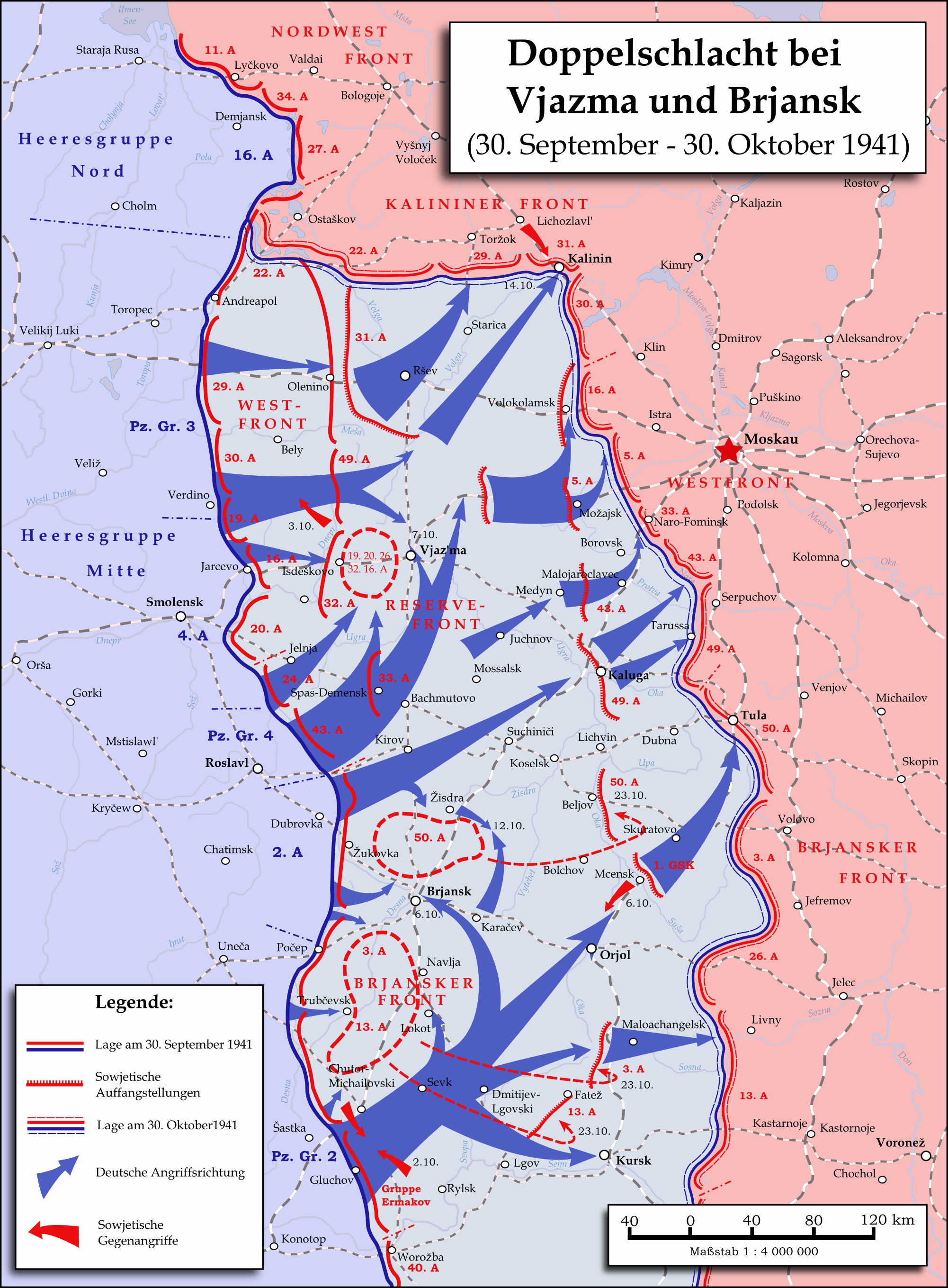
English: Map showing the two battles near Vyazma (October 2nd — October 20th 1941) and Brjansk (September 30th - October, 23rd) during the Second World War (1939—1945) at the Eastern Front. The map was created in Inkscape and is based on Map 30 in the attachment of the book P.N. Pospelow (Hrsg.): Geschichte des Großen Vaterländischen Krieges der Sowjetunion, Bd. 2, Berlin (Ost) 1963. The troop movements have been corrected.
Deutsch: Karte der Doppelschlacht im Raum Vjasma und Brjansk (30. September — 23. Oktober 1941) während des Zweiten Weltkrieges (1939—1945) an der Ostfront. Die Karte wurde mit Inkscape erstellt und basiert auf Karte Nr. 30 aus dem Anhang des Buches P.N. Pospelow (Hrsg.): Geschichte des Großen Vaterländischen Krieges der Sowjetunion, Bd. 2, Berlin (Ost) 1963. Die Truppenbewegungen wurden jedoch korrigiert. |
| Data | |
| Origem | Obra do próprio |
| Autor | Memnon335bc |
Licenciamento
Eu, titular dos direitos de autor desta obra, publico-a com a seguinte licença:
A utilização deste ficheiro é regulada nos termos da licença Creative Commons - Atribuição 3.0 Não Adaptada.
- Pode:
- partilhar – copiar, distribuir e transmitir a obra
- recombinar – criar obras derivadas
- De acordo com as seguintes condições:
- atribuição – Tem de fazer a devida atribuição da autoria, fornecer uma hiperligação para a licença e indicar se foram feitas alterações. Pode fazê-lo de qualquer forma razoável, mas não de forma a sugerir que o licenciador o apoia ou subscreve o seu uso da obra.
Histórico do ficheiro
Clique uma data e hora para ver o ficheiro tal como ele se encontrava nessa altura.
| Data e hora | Miniatura | Dimensões | Utilizador | Comentário | |
|---|---|---|---|---|---|
| atual | 22h06min de 31 de maio de 2015 | | 2 002 × 2 718 (1,56 MB) | Cmdrjameson | Compressed with pngout. Reduced by 600kB (27% decrease). |
| 12h01min de 18 de setembro de 2009 |  | 2 002 × 2 718 (2,15 MB) | Memnon335bc | {{Information |Description={{en|1=Map showing the Twin-Battlea near Vyazma (October 2nd — October 20th 1941) and Brjansk (September 30th - Octpber, 23rd) during the Second World War (1939—1945) at the Eastern Front. The map is created by Inkscape and |
Utilização local do ficheiro
A seguinte página usa este ficheiro:
Utilização global do ficheiro
As seguintes wikis usam este ficheiro:
- azb.wikipedia.org
- az.wikipedia.org
- ba.wikipedia.org
- be.wikipedia.org
- de.wikipedia.org
- en.wikipedia.org
- es.wikipedia.org
- et.wikipedia.org
- fa.wikipedia.org
- fr.wikipedia.org
- it.wikipedia.org
- ja.wikipedia.org
- nl.wikipedia.org
- pl.wikipedia.org
- ru.wikipedia.org
- sl.wikipedia.org
- th.wikipedia.org
- tr.wikipedia.org
- tt.wikipedia.org
- vi.wikipedia.org
- zh.wikipedia.org