
Ficheiro:MSH82 st helens plume from harrys ridge 05-19-82.jpg

Dimensões desta antevisão: 800 × 541 píxeis. Outras resoluções: 320 × 216 píxeis | 640 × 433 píxeis | 1 024 × 692 píxeis | 1 280 × 865 píxeis | 2 925 × 1 977 píxeis.
Imagem numa resolução maior (2 925 × 1 977 píxeis, tamanho: 3,77 MB, tipo MIME: image/jpeg)
|
|
Esta imagem provém do Wikimedia Commons, um acervo de conteúdo livre da Wikimedia Foundation que pode ser utilizado por outros projetos.
|
Descrição do ficheiro
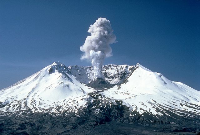
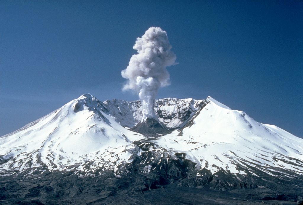
| Descrição | Plumes of steam, gas, and ash often occurred at Mount St. Helens in the early 1980s. On clear days they could be seen from Portland, Oregon, 50 mi (80 km) to the south. The plume photographed here rose nearly 3,000 ft (910 m) above the volcano's rim. The view is from Harrys Ridge, 5 mi (8 km) north of the mountain. | |||
| Data | ||||
| Origem |
CVO Photo Archive Mount St. Helens, Washington Before, During, and After 18 May 1980. |
|||
| Autor | Lyn Topinka | |||
| Permissão (Reutilizar este ficheiro) |
|
Histórico do ficheiro
Clique uma data e hora para ver o ficheiro tal como ele se encontrava nessa altura.
| Data e hora | Miniatura | Dimensões | Utilizador | Comentário | |
|---|---|---|---|---|---|
| atual | 18h17min de 28 de novembro de 2007 | | 2 925 × 1 977 (3,77 MB) | CarolSpears | {{Information |Description=Plumes of steam, gas, and ash often occured at Mount St. Helens in the early 1980s. On clear days they could be seen from Portland, Oregon, 50 miles (81 kilometers) to the south. The plume photographed here rose nearly 3,000 fee |
Utilização local do ficheiro
As seguintes 9 páginas usam este ficheiro:
Utilização global do ficheiro
As seguintes wikis usam este ficheiro:
- af.wikipedia.org
- ar.wikipedia.org
- arz.wikipedia.org
- ast.wikipedia.org
- ba.wikipedia.org
- be.wikipedia.org
- bg.wikipedia.org
- bh.wikipedia.org
- bn.wikipedia.org
- ca.wikipedia.org
- ceb.wikipedia.org
- cs.wikipedia.org
- cy.wikipedia.org
- da.wikipedia.org
- de.wikipedia.org
- de.wikivoyage.org
- el.wikipedia.org
- en.wikipedia.org
- Talk:Plate tectonics
- Talk:Volcanic explosivity index
- Mount St. Helens
- Talk:Gabbro
- Talk:Azores
- Talk:Long Valley Caldera
- Talk:Andaman Islands
- Talk:Age of Earth
- Talk:Maui
- Talk:Lanai
- Talk:Easter Island
- Talk:Staffa
- Talk:Mauna Loa
- Talk:Cascade Range
- Talk:Réunion
- Talk:Mount Baker
- Talk:Toba catastrophe theory
- Talk:Pliny the Elder
- Talk:Belcher Islands
- Talk:Mid-Atlantic Ridge
Ver mais utilizações globais deste ficheiro.