
Ficheiro:Faroe islands map with island names.png

Dimensões desta antevisão: 450 × 600 píxeis. Outras resoluções: 180 × 240 píxeis | 600 × 800 píxeis.
Imagem numa resolução maior (600 × 800 píxeis, tamanho: 29 kB, tipo MIME: image/png)
|
|
Esta imagem provém do Wikimedia Commons, um acervo de conteúdo livre da Wikimedia Foundation que pode ser utilizado por outros projetos.
|
Descrição do ficheiro
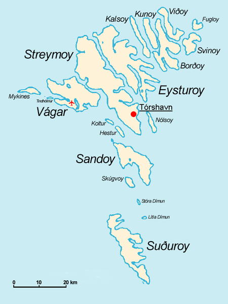
Español: Mapa de las Islas Feroe. Posición del aeropuerto marcado con el avión rojo.
- The Faroe Islands
- Graphics Arne List
- Description: This basic map shows the names of the 18 islands plus the islet Tindhólmur west of Vágar, which is not counted as one of the islands. Furthermore, on this map you see the Airport Vágar and the capital Tórshavn, the two international destinations, if you come via plane or ferry. Last but not least bears the sea no caption, for this map should be translated in different languages by yourself. The sea in the West is the North Atlantic Ocean, and in the East Norwegian Sea (which is a part of the Atlantic).

|
É concedida permissão para copiar, distribuir e/ou modificar este documento nos termos da Licença de Documentação Livre GNU, versão 1.2 ou qualquer versão posterior publicada pela Free Software Foundation; sem Secções Invariantes, sem textos de Capa e sem textos de Contra-Capa. É incluída uma cópia da licença na secção intitulada GNU Free Documentation License. |
| A utilização deste ficheiro é regulada nos termos da licença Creative Commons - Atribuição-CompartilhaIgual 3.0 Não Adaptada. | ||
| ||
| Esta marca de licenciamento foi adicionada a este ficheiro durante a atualização da licença GFDL. |
derivative works
Obras derivadas deste ficheiro: Faroe islands map with island names-2.JPG
Histórico do ficheiro
Clique uma data e hora para ver o ficheiro tal como ele se encontrava nessa altura.
| Data e hora | Miniatura | Dimensões | Utilizador | Comentário | |
|---|---|---|---|---|---|
| atual | 09h32min de 18 de novembro de 2004 | | 600 × 800 (29 kB) | Arne List | GFDL |
Utilização local do ficheiro
As seguintes 2 páginas usam este ficheiro:
Utilização global do ficheiro
As seguintes wikis usam este ficheiro:
- azb.wikipedia.org
- be.wikipedia.org
- ca.wikipedia.org
- cs.wikipedia.org
- da.wikipedia.org
- de.wikipedia.org
- ee.wikipedia.org
- eo.wikipedia.org
- eu.wikipedia.org
- ext.wikipedia.org
- fo.wikipedia.org
- fr.wikipedia.org
- fr.wiktionary.org
- ga.wikipedia.org
- gl.wikipedia.org
- hu.wikipedia.org
- id.wikipedia.org
- is.wikipedia.org
- mr.wikipedia.org
- nl.wikipedia.org
- nn.wikipedia.org
- no.wikipedia.org
- os.wikipedia.org
- pl.wikipedia.org
- ru.wikipedia.org
- sh.wikipedia.org
- sr.wikipedia.org
- sv.wikipedia.org
- vi.wikipedia.org
- zh.wikipedia.org