
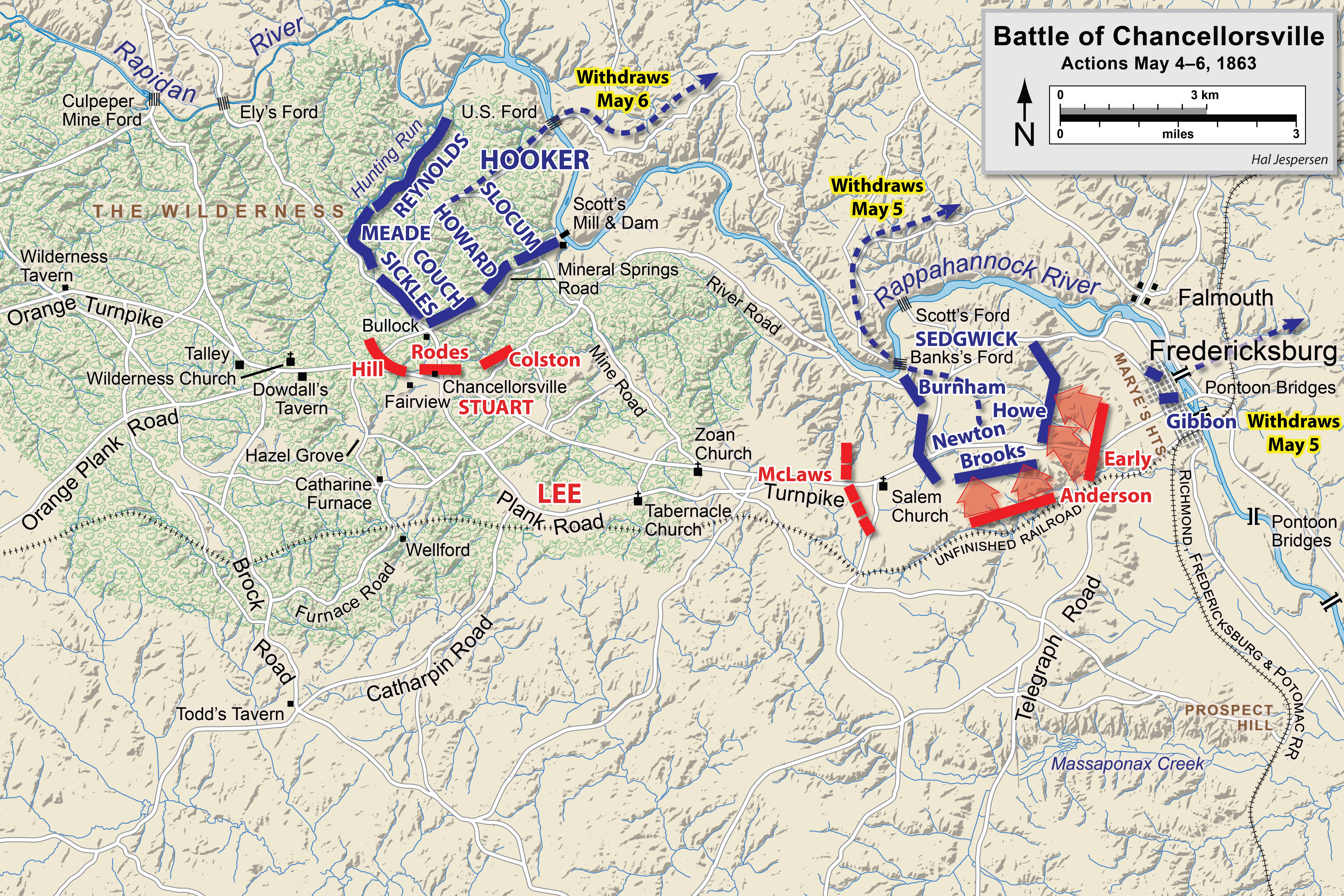
Ficheiro:Chancellorsville May4-6.png
Dimensões desta antevisão: 800 × 533 píxeis. Outras resoluções: 320 × 213 píxeis | 640 × 427 píxeis | 1 024 × 683 píxeis | 1 280 × 854 píxeis | 2 560 × 1 707 píxeis | 6 300 × 4 201 píxeis.
Imagem numa resolução maior (6 300 × 4 201 píxeis, tamanho: 8,55 MB, tipo MIME: image/png)
|
|
Esta imagem provém do Wikimedia Commons, um acervo de conteúdo livre da Wikimedia Foundation que pode ser utilizado por outros projetos.
|
| Descrição |
English: Map of a portion (May 4-6) of the battle of Chancellorsville of the American Civil War. This map replaces the map entitled Chancellorsville May4.png.
Drawn in Adobe Illustrator CS6 by Hal Jespersen. Graphic source file is available at http://www.cwmaps.com A utilização deste ficheiro é regulada nos termos da licença Creative Commons - Atribuição 3.0 Não Adaptada. Atribuição: Map by Hal Jespersen, www.cwmaps.com
|
| Data | |
| Origem | Obra do próprio |
| Autor | Hlj |
Histórico do ficheiro
Clique uma data e hora para ver o ficheiro tal como ele se encontrava nessa altura.
| Data e hora | Miniatura | Dimensões | Utilizador | Comentário | |
|---|---|---|---|---|---|
| atual | 18h15min de 14 de março de 2023 | | 6 300 × 4 201 (8,55 MB) | Hlj | improved graphics |
| 17h52min de 30 de dezembro de 2012 |  | 2 500 × 1 822 (1,37 MB) | Hlj | Corrected spelling error, made minor graphic improvements | |
| 22h17min de 3 de junho de 2011 |  | 2 500 × 1 822 (1,31 MB) | Hlj | Improved the accuracy of the terrain and some landmarks. Same license. | |
| 19h33min de 27 de março de 2011 |  | 2 500 × 1 822 (1,28 MB) | Hlj | Update to graphical style of rivers and roads. Same license. | |
| 22h01min de 27 de janeiro de 2011 |  | 2 500 × 1 822 (1 005 kB) | Hlj | Minor updates to feature labeling and unit positions and actions. {{cc-by-3.0|Map by Hal Jespersen, www.posix.com/CW}} | |
| 00h17min de 28 de novembro de 2010 |  | 2 500 × 1 822 (999 kB) | Hlj | {{Information |Description={{en|1=Map of a portion (May 4-6) of the battle of Chancellorsville of the American Civil War. This map replaces the map entitled Chancellorsville May4.png. Drawn in Adobe Illustrator CS5 by Hal Jespersen. Graphic source fil |
Utilização local do ficheiro
As seguintes 2 páginas usam este ficheiro:
Utilização global do ficheiro
As seguintes wikis usam este ficheiro:
- en.wikipedia.org
- es.wikipedia.org
- fr.wikipedia.org
- hu.wikipedia.org
- ms.wikipedia.org
- ro.wikipedia.org