
Ficheiro:Ducie Island from Space (ISS002-E-10044).jpg

Imagem numa resolução maior (3 060 × 2 032 píxeis, tamanho: 1,12 MB, tipo MIME: image/jpeg)
|
|
Esta imagem provém do Wikimedia Commons, um acervo de conteúdo livre da Wikimedia Foundation que pode ser utilizado por outros projetos.
|
.jpg)
Descrição do ficheiro
| Descrição |
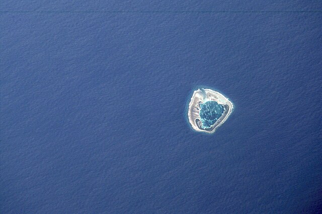
English: Ducie Island as photographed by NASA in 2001 |
| Data | |
| Origem | Astronaut Photography of Earth - Display Record ISS002-E-10044 |
| Autor | NASA |
Mission: ISS002 Roll: E Frame: 10044 Mission ID on the Film or image: ISS002 Country or Geographic Name: Pitcairn Islands Features: Ducie Island Center Point Latitude: -24.5 Center Point Longitude: -125.0 (Negative numbers indicate south for latitude and west for longitude)
Date: 20010724 (YYYYMMDD)GMT Time: 190142 (HHMMSS) Nadir Point Latitude: -26.7, Longitude: -126.2 (Negative numbers indicate south for latitude and west for longitude) Nadir to Photo Center Direction: Northeast Sun Azimuth: 27 (Clockwise angle in degrees from north to the sun measured at the nadir point) Spacecraft Altitude: 211 nautical miles (391 km) Sun Elevation Angle: 39 (Angle in degrees between the horizon and the sun, measured at the nadir point) Orbit Number: 3297
Licenciamento
| Este ficheiro está no domínio público nos Estados Unidos porque foi criado exclusivamente pela NASA. As orientações sobre o direito de autor da NASA são que «as obras da NASA não têm os direitos de autor protegidos salvo indicação em contrário». Veja Template:PD-USGov, as orientações sobre o direito de autor da NASA ou as normas de uso de imagens do Laboratório de Propulsão a Jato (Jet Propulsion Lab, JPL). | ||
 |
Avisos:
|
Histórico do ficheiro
Clique uma data e hora para ver o ficheiro tal como ele se encontrava nessa altura.
| Data e hora | Miniatura | Dimensões | Utilizador | Comentário | |
|---|---|---|---|---|---|
| atual | 12h36min de 2 de dezembro de 2014 | | 3 060 × 2 032 (1,12 MB) | Ras67 | high res |
| 20h10min de 3 de julho de 2011 |  | 3 060 × 2 092 (1,15 MB) | GDuwen | {{Information |Description ={{en|1=Ducie Island as photographed by NASA in 2001}} |Source =Astronaut Photography of Earth - Display Record ISS002-E-10044 |Author =NASA |Date =July 24, 2001 |Permission = |other_versions = } |
Utilização local do ficheiro
A seguinte página usa este ficheiro:
Utilização global do ficheiro
As seguintes wikis usam este ficheiro:
- cs.wikipedia.org
- it.wikipedia.org
- ru.wikipedia.org
.jpg)