
Ficheiro:Earth's City Lights by DMSP, 1994-1995 (medium).png
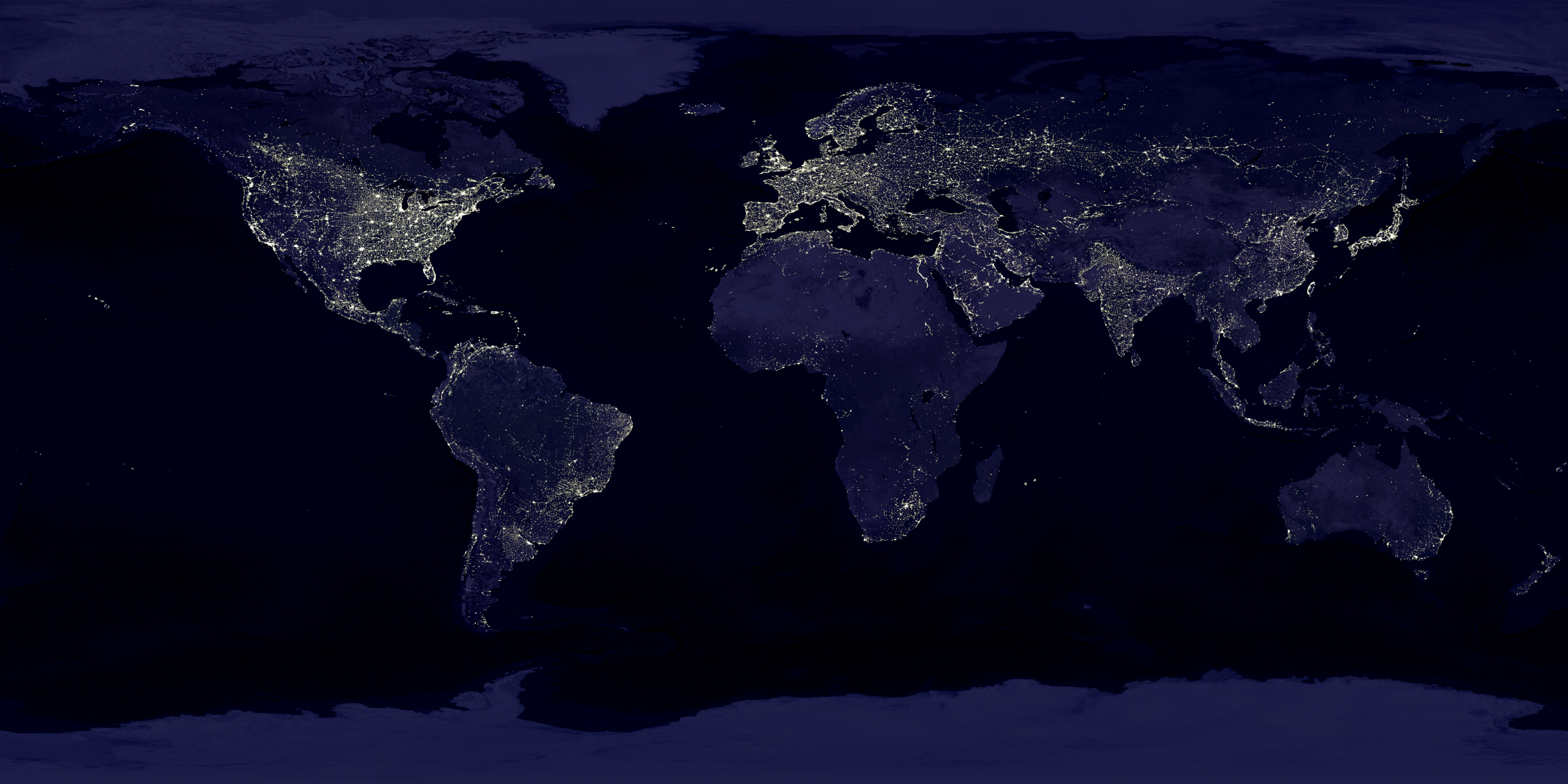
Imagem numa resolução maior (2 560 × 1 280 píxeis, tamanho: 2,56 MB, tipo MIME: image/png)
|
|
Esta imagem provém do Wikimedia Commons, um acervo de conteúdo livre da Wikimedia Foundation que pode ser utilizado por outros projetos.
|
Descrição do ficheiro
| Descrição |
English: This image of Earth’s city lights was created with data from the Defense Meteorological Satellite Program (DMSP) Operational Linescan System (OLS). Originally designed to view clouds by moonlight, the OLS is also used to map the locations of permanent lights on the Earth’s surface.
The brightest areas of the Earth are the most urbanized, but not necessarily the most populated. (Compare western Europe with China and India.) Cities tend to grow along coastlines and transportation networks. Even without the underlying map, the outlines of many continents would still be visible. The United States interstate highway system appears as a lattice connecting the brighter dots of city centers. In Russia, the Trans-Siberian railroad is a thin line stretching from Moscow through the center of Asia to Vladivostok. The Nile River, from the Aswan Dam to the Mediterranean Sea, is another bright thread through an otherwise dark region. Even more than 100 years after the invention of the electric light, some regions remain thinly populated and unlit. Antarctica is entirely dark. The interior jungles of Africa and South America are mostly dark, but lights are beginning to appear there. Deserts in Africa, Arabia, Australia, Mongolia, and the United States are poorly lit as well (except along the coast), along with the boreal forests of Canada and Russia, and the great mountains of the Himalaya. |
| Data | entre 1 de outubro de 1994 e 31 de março de 1995 |
| Origem | https://visibleearth.nasa.gov/view.php?id=55167 (image link) |
| Autor | Data: Marc Imhoff/NASA GSFC, Christopher Elvidge/NOAA NGDC; Image: Craig Mayhew and Robert Simmon/NASA GSFC |
| Outras versões |
|
.jpg)
.jpg)
.png)

.png)
Licenciamento
| Este ficheiro está no domínio público nos Estados Unidos porque foi criado exclusivamente pela NASA. As orientações sobre o direito de autor da NASA são que «as obras da NASA não têm os direitos de autor protegidos salvo indicação em contrário». Veja Template:PD-USGov, as orientações sobre o direito de autor da NASA ou as normas de uso de imagens do Laboratório de Propulsão a Jato (Jet Propulsion Lab, JPL). | ||
 |
Avisos:
|
Esta imagem está em domínio público pois ela contém material que vieram originalmente da National Oceanic and Atmospheric Administration dos EUA, tirada ou feita durante o trajeto de um funcionário em obrigações oficiais.
|
Histórico do ficheiro
Clique uma data e hora para ver o ficheiro tal como ele se encontrava nessa altura.
| Data e hora | Miniatura | Dimensões | Utilizador | Comentário | |
|---|---|---|---|---|---|
| atual | 18h49min de 15 de abril de 2017 | | 2 560 × 1 280 (2,56 MB) | Huntster | Standardise appearance in series. |
| 20h45min de 9 de março de 2009 |  | 2 560 × 1 364 (2,18 MB) | Tryphon | Higher resolution. | |
| 15h05min de 18 de setembro de 2007 |  | 1 499 × 797 (658 kB) | Jonathan Kovaciny~commonswiki | Re-cropped version of original NASA image. | |
| 15h03min de 18 de setembro de 2007 |  | 1 521 × 797 (667 kB) | Jonathan Kovaciny~commonswiki | Cropped version of the original NASA image. | |
| 16h26min de 30 de março de 2007 |  | 1 500 × 1 125 (1,61 MB) | Laur2ro | {{Information |Description=Earth lights, image is slightly edited (increased contrast and brightness; similar to Image:Whole world - at night.png, but the continents are visible also). |Source=http://visibleearth.nasa.gov/view_rec.php?id=11793 |Date=m |
Utilização local do ficheiro
Não há nenhuma página que use este ficheiro.
Utilização global do ficheiro
As seguintes wikis usam este ficheiro:
- ar.wikipedia.org
- ca.wikipedia.org
- en.wikipedia.org
- en.wikiquote.org
- en.wikiversity.org
- es.wikinews.org
- fr.wikipedia.org
- fr.wikiversity.org
- ha.wikipedia.org
- hi.wikipedia.org
- hr.wikipedia.org
- it.wikipedia.org
- mwl.wikipedia.org
- pl.wikipedia.org
- ru.wikipedia.org
- sh.wikipedia.org
- uk.wikipedia.org
- uz.wikipedia.org
- www.wikidata.org
.png)