
Ficheiro:Gonu rainfall.jpg
Gonu_rainfall.jpg (540 × 356 píxeis, tamanho: 114 kB, tipo MIME: image/jpeg)
|
|
Esta imagem provém do Wikimedia Commons, um acervo de conteúdo livre da Wikimedia Foundation que pode ser utilizado por outros projetos.
|
Descrição do ficheiro
| Descrição |
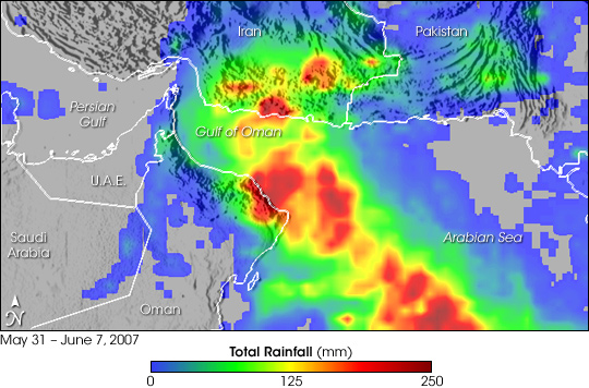
Despite weakening from a Category 5 to a Category 1 cyclone as it neared the Arabian Peninsula, Tropical Cyclone Gonu was responsible for at least 28 fatalities in the region, mostly as a result of flooding, said news reports. In Oman’s capital city of Muscat, torrential rains turned streets into rivers of water in this normally arid region. In addition to the 25 confirmed fatalities in Oman, at least 26 other people were reported missing. Iran had reported 3 deaths as a result of the storm as of June 7, 2007. This visualization shows rainfall totals from May 31 through June 7, 2007, from the Multi-satellite Precipitation Analysis (MPA). Although the center of Gonu never made landfall in Oman, it came very close to the northeast coastline where it dumped upwards up 200 millimeters of rain (8 inches, shown in dark red). The capital region of Muscat is on the coast where some of the heaviest rain fell. Despite further weakening as it traversed the Gulf of Oman between Oman and southern Iran, Gonu dumped substantial amounts of rain in southern Iran (broad green area) with locally heavy amounts. The mountainous terrain near the coast of Oman and Iran posed an additional hazard to coastal regions. Heavy rain falling on the steep mountains sent torrents of fast-moving floodwater down to the coastal areas. The MPA is computed at NASA Goddard Space Flight center in near-real time using data from the Tropical Rainfall Measuring Mission (TRMM). The TRMM satellite was placed into service in November 1997. From its low-earth orbit, TRMM provides valuable images and information on storm systems around the tropics using a combination of passive microwave and active radar sensors, including the first precipitation radar in space. TRMM is a joint mission between NASA and the Japanese space agency, JAXA. |
| Data | |
| Origem | http://earthobservatory.nasa.gov/NaturalHazards/natural_hazards_v2.php3?img_id=14295 |
| Autor | NASA image produced by Hal Pierce (SSAI/NASA GSFC) and caption by Steve Lang (SSAI/NASA GSFC). |
Licenciamento
| Este ficheiro está no domínio público nos Estados Unidos porque foi criado exclusivamente pela NASA. As orientações sobre o direito de autor da NASA são que «as obras da NASA não têm os direitos de autor protegidos salvo indicação em contrário». Veja Template:PD-USGov, as orientações sobre o direito de autor da NASA ou as normas de uso de imagens do Laboratório de Propulsão a Jato (Jet Propulsion Lab, JPL). | ||
 |
Avisos:
|
Histórico do ficheiro
Clique uma data e hora para ver o ficheiro tal como ele se encontrava nessa altura.
| Data e hora | Miniatura | Dimensões | Utilizador | Comentário | |
|---|---|---|---|---|---|
| atual | 06h48min de 8 de junho de 2007 | | 540 × 356 (114 kB) | RaNdOm26~commonswiki | == Summary == {{Information |Description=Despite weakening from a Category 5 to a Category 1 cyclone as it neared the Arabian Peninsula, Tropical Cyclone Gonu was responsible for at least 28 fatalities in the region, mostly as a result of flooding, said n |
Utilização local do ficheiro
A seguinte página usa este ficheiro:
Utilização global do ficheiro
As seguintes wikis usam este ficheiro:
- ar.wikipedia.org
- de.wikipedia.org
- en.wikipedia.org
- fr.wikipedia.org
- nl.wikipedia.org
- te.wikipedia.org
- uk.wikipedia.org
- zh.wikipedia.org