
Ficheiro:Japanese Occupation - Map.jpg
Imagem numa resolução maior (1 119 × 857 píxeis, tamanho: 482 kB, tipo MIME: image/jpeg)
|
|
Esta imagem provém do Wikimedia Commons, um acervo de conteúdo livre da Wikimedia Foundation que pode ser utilizado por outros projetos.
|

|
File:Japanese Occupation of China 1940.svg é uma versão vetorial deste ficheiro. Ela deve ser usada em vez desta imagem em formato raster, se não for de qualidade inferior.
File:Japanese Occupation - Map.jpg → File:Japanese Occupation of China 1940.svg
Para mais informações, consulte Ajuda:SVG. |
 |
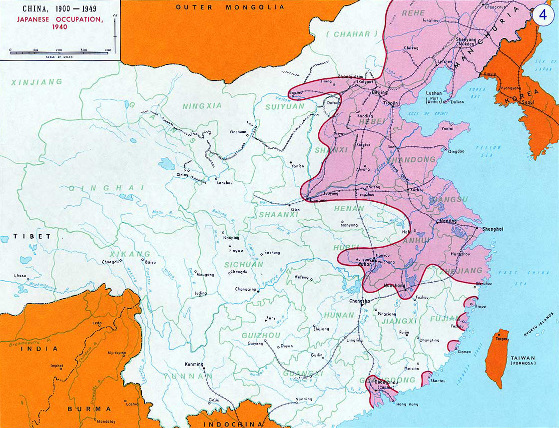
- Description: English: Japanese Occupation - 1940Bân-lâm-gú:Ji̍t-pún 1940-nî tī Tiong-kok tsiàm ê sóo-tsāi(hún-âng-sik).中文:中国抗日战争中,1940年日军占领区(粉紅色)。
- Source: www.dean.usma.edu - The photo source linked here only has the photo in this low-resolution JPG format.
- Other versions: File:Second Sino-Japanese War WW2.png
- Background information:
In 1938 the predecessors of what is today The Department of History at the United States Military Academy began developing a series of campaign atlases to aid in teaching cadets a course entitled, "History of the Military Art." Since then, the Department has produced over six atlases and more than one thousand maps, encompassing not only America’s wars but global conflicts as well.
In keeping abreast with today's technology, the Department of History is providing these maps on the internet as part of the department's outreach program. The maps were created by the United States Military Academy’s Department of History and are the digital versions from the atlases printed by the United States Defense Printing Agency. We gratefully acknowledge the accomplishments of the department's former cartographer, Mr. Edward J. Krasnoborski, along with the works of our present cartographer, Mr. Frank Martini.
Please be aware that these maps are large in file size and may require substantial download times.
Esta imagem é um trabalho de um soldado ou funcionário do Exército dos Estados Unidos, tirada ou feita durante o curso de uma tarefa oficial. Como trabalho do Governo Federal dos Estados Unidos, a imagem está em domínio público.
|
 |
derivative works
Obras derivadas deste ficheiro: OcupaciónJaponesaDeChina1940.svg
Histórico do ficheiro
Clique uma data e hora para ver o ficheiro tal como ele se encontrava nessa altura.
| Data e hora | Miniatura | Dimensões | Utilizador | Comentário | |
|---|---|---|---|---|---|
| atual | 19h17min de 14 de novembro de 2012 | | 1 119 × 857 (482 kB) | Mys 721tx | Reverted to version as of 22:05, 9 March 2010 Revert to larger picture. |
| 03h58min de 14 de novembro de 2012 |  | 699 × 600 (111 kB) | Amysze123 | ||
| 22h05min de 9 de março de 2010 |  | 1 119 × 857 (482 kB) | Ras67 | rotated and cropped | |
| 08h32min de 17 de junho de 2005 |  | 1 141 × 870 (172 kB) | W.wolny |
Utilização local do ficheiro
As seguintes 3 páginas usam este ficheiro:
Utilização global do ficheiro
As seguintes wikis usam este ficheiro:
- ar.wikipedia.org
- be.wikipedia.org
- bs.wikipedia.org
- ca.wikipedia.org
- cs.wikipedia.org
- da.wikipedia.org
- el.wikipedia.org
- en.wikipedia.org
- en.wikibooks.org
- es.wikipedia.org
- et.wikipedia.org
- fi.wikipedia.org
- fr.wikipedia.org
- he.wikipedia.org
- hr.wikipedia.org
- hu.wikipedia.org
- hy.wikipedia.org
- id.wikipedia.org
- ja.wikipedia.org
- jv.wikipedia.org
- kk.wikipedia.org
- ko.wikipedia.org
- la.wikipedia.org
- lv.wikipedia.org
- ms.wikipedia.org
- my.wikipedia.org
- nl.wikipedia.org
- no.wikipedia.org
Ver mais utilizações globais deste ficheiro.