
Ficheiro:Jerusalem-barrier June 2007-OCHAoPt.jpeg

Imagem numa resolução maior (1 159 × 1 092 píxeis, tamanho: 190 kB, tipo MIME: image/jpeg)
|
|
Esta imagem provém do Wikimedia Commons, um acervo de conteúdo livre da Wikimedia Foundation que pode ser utilizado por outros projetos.
|
Descrição do ficheiro
| Descrição |
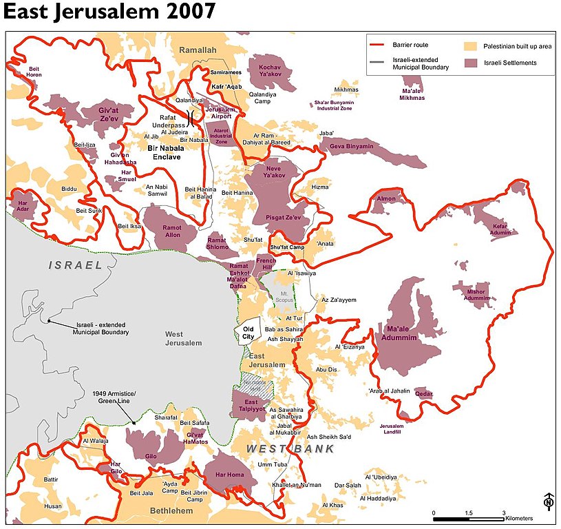
English: Jerusalem barrier, update June 2007. Planned route, including parts at the time not yet realized. From: The Humanitarian Impact of the West Bank Barrier on Palestinian Communities: East Jerusalem |
| Data | |
| Origem | http://unispal.un.org/pdfs/HI_Barrier_EJerusalem.pdf |
| Autor | UN OCHA oPt |
Licenciamento
| This image is a map derived from a United Nations map.
Unless stated otherwise, UN maps are to be considered in the public domain. This applies worldwide. UN maps are, in principle, open source material and you can use them in your work or for making your own map. UN requests however that you delete the UN name, logo and reference number upon any modification to the map. Content of your map will be your responsibility. You can state in your publication, if you wish, something like: based on UN map … (map name, map number, revision number and date). See: Geospatial Information Section. And: Geospatial, location data for a better world. |
 |
Histórico do ficheiro
Clique uma data e hora para ver o ficheiro tal como ele se encontrava nessa altura.
| Data e hora | Miniatura | Dimensões | Utilizador | Comentário | |
|---|---|---|---|---|---|
| atual | 09h46min de 2 de julho de 2013 | | 1 159 × 1 092 (190 kB) | Wickey-nl | User created page with UploadWizard |
Utilização local do ficheiro
A seguinte página usa este ficheiro:
Utilização global do ficheiro
As seguintes wikis usam este ficheiro:
- bn.wikipedia.org
- el.wikipedia.org
- en.wikipedia.org
- eo.wikipedia.org
- fr.wikipedia.org
- fy.wikipedia.org
- nl.wikipedia.org
- ru.wikipedia.org
- tr.wikipedia.org
- uk.wikipedia.org
- zh.wikipedia.org