
Ficheiro:Laurie island map-en.svg

Dimensões desta antevisão em PNG do ficheiro SVG: 800 × 420 píxeis Outras resoluções: 320 × 168 píxeis | 640 × 336 píxeis | 1 024 × 537 píxeis | 1 280 × 672 píxeis | 2 560 × 1 343 píxeis | 867 × 455 píxeis.
Imagem numa resolução maior (ficheiro SVG, de 867 × 455 píxeis, tamanho: 133 kB)
|
|
Esta imagem provém do Wikimedia Commons, um acervo de conteúdo livre da Wikimedia Foundation que pode ser utilizado por outros projetos.
|
Descrição do ficheiro
| Descrição |
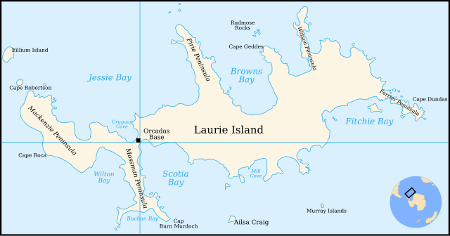
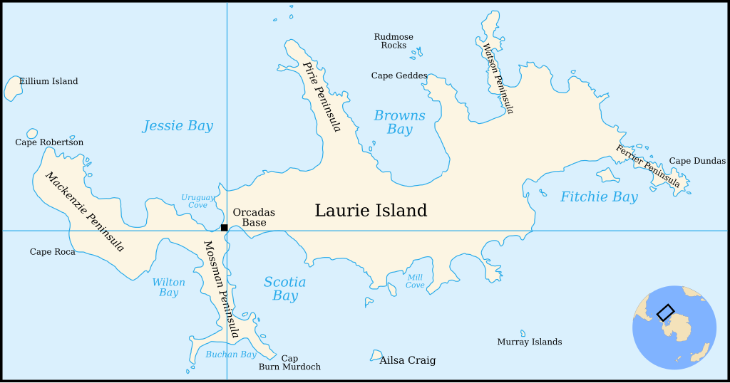
English: Map of Laurie Island, South Orkney Islands |
| Data | |
| Origem | Translation of File:Laurie island map-fr.svg |
| Autor | Original by Pinpin, translated to English by 4ing |
| Outras versões | In French: File:Laurie island map-fr.svg |

|
Este ficheiro SVG contém texto integrado que pode ser traduzido para a sua língua, usando um editor que possa suportar SVG (como XML ou texto). Para mais informações, consulte: Sobre a tradução de ficheiros SVG. |
Licenciamento

|
É concedida permissão para copiar, distribuir e/ou modificar este documento nos termos da Licença de Documentação Livre GNU, versão 1.2 ou qualquer versão posterior publicada pela Free Software Foundation; sem Secções Invariantes, sem textos de Capa e sem textos de Contra-Capa. É incluída uma cópia da licença na secção intitulada GNU Free Documentation License. |
| A utilização deste ficheiro é regulada nos termos da licença Creative Commons - Atribuição-CompartilhaIgual 3.0 Não Adaptada. | ||
| Atribuição: Pinpin and 4ing | ||
| ||
| Esta marca de licenciamento foi adicionada a este ficheiro durante a atualização da licença GFDL. |
Histórico do ficheiro
Clique uma data e hora para ver o ficheiro tal como ele se encontrava nessa altura.
| Data e hora | Miniatura | Dimensões | Utilizador | Comentário | |
|---|---|---|---|---|---|
| atual | 21h29min de 4 de janeiro de 2011 | | 867 × 455 (133 kB) | 4ing | == {{int:filedesc}} == {{Information |Description={{en|1=Map of Laurie Island, South Orkney Islands}} |Source=Translation of File:Laurie island map-fr.svg |Author=Original by Pinpin, translated to English by 4ing |Date=2 |
Utilização local do ficheiro
A seguinte página usa este ficheiro:
Utilização global do ficheiro
As seguintes wikis usam este ficheiro:
- be.wikipedia.org
- bg.wikipedia.org
- ceb.wikipedia.org
- de.wikipedia.org
- Laurie Island
- Orcadas-Station
- Scotia Bay
- Mossman-Halbinsel
- Wilton Bay
- Mackenzie-Halbinsel
- Ailsa Craig (Südliche Orkneyinseln)
- Kap Anderson
- Mill Cove
- Valette Island
- Baldred Rock
- Graptolite Island
- Fitchie Bay
- Ferrier-Halbinsel
- Kap Dundas
- Kap Geddes
- Browns Bay (Laurie Island)
- Pirie-Halbinsel
- Rudmose Rocks
- Watson-Halbinsel
- Kap Mabel
- Jessie Bay
- Marr Bay
- Kap Robertson
- Kap Valavielle
- Buchan Bay
- Uruguay Cove
- en.wikipedia.org
- eo.wikipedia.org
- es.wikipedia.org
- fi.wikipedia.org
- fr.wikipedia.org
- he.wikipedia.org
- ja.wikipedia.org
- ka.wikipedia.org
- lld.wikipedia.org
- mk.wikipedia.org
- nn.wikipedia.org
Ver mais utilizações globais deste ficheiro.