
Ficheiro:LocationNSAngloLatin.png
Dimensões desta antevisão: 600 × 600 píxeis. Outras resoluções: 240 × 240 píxeis | 480 × 480 píxeis.
Imagem numa resolução maior (800 × 800 píxeis, tamanho: 49 kB, tipo MIME: image/png)
|
|
Esta imagem provém do Wikimedia Commons, um acervo de conteúdo livre da Wikimedia Foundation que pode ser utilizado por outros projetos.
|
Descrição do ficheiro
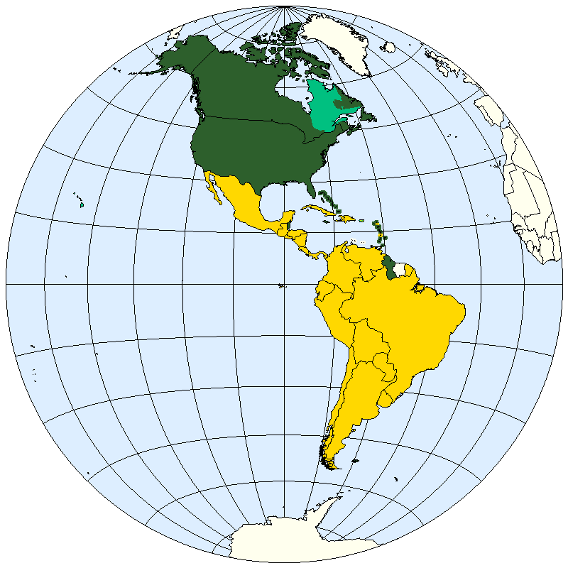
| Descrição | Division of the Americas into Anglo-America and Latin America. |
| Data | |
| Origem | prepared from public domain maps created by w:en:User:E Pluribus Anthony. |
| Autor | Spacepotato |
Legend
- 2D5F2C: Anglo-America.
- 00C080: May be included in Anglo-America or in Latin-America
- FFD800: Latin America.
- FFFC00: May be included in Latin America.
References
Anglo-America
- Broad definition: "North America". The Columbia Encyclopedia, Sixth Edition. 2001-05. Accessed on line October 11, 2007. Defines Anglo-America as Canada together with the U.S.A.
- Narrow definition: "Anglo-America". Encyclopedia Brittanica, on line. Accessed October 10, 2007. Defines Anglo-America as a "cultural entity of North America" which "comprises most of the United States and Canada, with French-speaking Canada a notable exception".
Latin America
- Broad definition: "Latin America". Brittanica Student Encyclopedia, on line. Accessed October 10, 2007. Defines Latin America as "South America, Mexico, Central America, and the West Indies".
- Intermediate definition: "Latin America". Columbia Encyclopedia, Sixth Edition, 2007. Accessed on line October 11, 2007. Defines Latin America as including the mainland independent nations south of the U.S.A. (except Belize, Guyana and Suriname), Cuba, the Dominican Republic, Haiti, and "Puerto Rico, the French West Indies, and other islands of the West Indies where a Romance tongue is spoken." Term may also include Belize, Guyana, French Guiana, and Suriname.
- Narrow definition: "Latin America". The American Heritage New Dictionary of Cultural Literacy, Third Edition, 2005. Accessed on line October 11, 2007. Defines Latin America as all of the "Spanish- or Portuguese-speaking nations south of the United States."
Licenciamento
| Eu, titular dos direitos de autor desta obra, dedico-a ao domínio público, com aplicação em todo o mundo. Nalguns países isto pode não ser legalmente possível; se assim for: Concedo a todos o direito de usar esta obra para qualquer fim, sem quaisquer condições, a menos que tais condições sejam impostas por lei. |
See also
- Image:LocationNSAm.png
- Image:LocationNSAm2.png
- Image:LocationNSAm3.png
- Image:LocationNSAmUNGeoscheme.png
Histórico do ficheiro
Clique uma data e hora para ver o ficheiro tal como ele se encontrava nessa altura.
| Data e hora | Miniatura | Dimensões | Utilizador | Comentário | |
|---|---|---|---|---|---|
| atual | 18h08min de 22 de janeiro de 2021 | | 800 × 800 (49 kB) | Kiwi Rex | Corrected inaccuracies. The map was updated according to Wikipedia's (and Wiktionary's) own usage of the terms, which is already visually represented in the images File:Latin America (orthographic projection).svg and File:Anglo America (orthographic projection).svg. Countries that don't speak Latin-derived languages (such as Jamaica and Suriname) are not "Latin American". |
| 20h38min de 11 de outubro de 2007 |  | 800 × 800 (21 kB) | Spacepotato | {{Information |Description=Division of the Americas into Anglo-America and Latin America. |Source=prepared from public domain maps created by w:en:User:E Pluribus Anthony. |Date=October 11, 2007. |Author= Spacepotato }} ==Legend== |
.svg)
.svg&action=edit&redlink=1)
Utilização local do ficheiro
A seguinte página usa este ficheiro:
Utilização global do ficheiro
As seguintes wikis usam este ficheiro:
- ar.wikipedia.org
- bn.wikipedia.org
- ca.wikipedia.org
- en.wikipedia.org
- kn.wikipedia.org