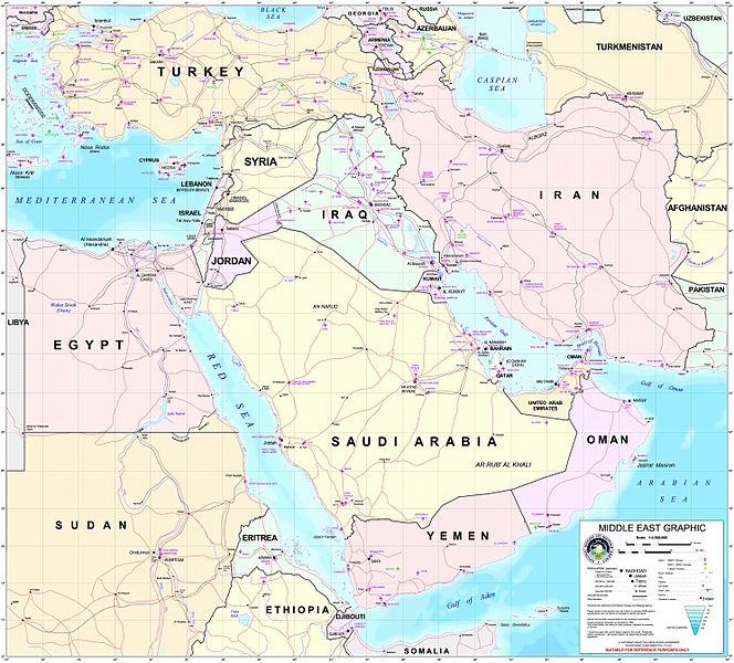
Ficheiro:Middle east graphic 2003.jpg

Dimensões desta antevisão: 664 × 600 píxeis. Outras resoluções: 266 × 240 píxeis | 532 × 480 píxeis | 850 × 768 píxeis | 1 134 × 1 024 píxeis | 2 268 × 2 048 píxeis | 2 973 × 2 685 píxeis.
Imagem numa resolução maior (2 973 × 2 685 píxeis, tamanho: 3,91 MB, tipo MIME: image/jpeg)
Histórico do ficheiro
Clique uma data e hora para ver o ficheiro tal como ele se encontrava nessa altura.
| Data e hora | Miniatura | Dimensões | Utilizador | Comentário | |
|---|---|---|---|---|---|
| atual | 22h30min de 8 de fevereiro de 2012 |  | 2 973 × 2 685 (3,91 MB) | M0tty | Remove compression artefacts by a bilateral filtering. |
| 21h43min de 14 de julho de 2006 |  | 2 973 × 2 685 (1 013 kB) | Unquietwiki | ''Courtesy of the University of Texas Libraries, The University of Texas at Austin'' [http://www.lib.utexas.edu/maps/middle_east.html http://www.lib.utexas.edu/maps/middle_east.html] High-resolution political / railway / roadmap of the Middle East. |
Utilização local do ficheiro
As seguintes 4 páginas usam este ficheiro:
Utilização global do ficheiro
As seguintes wikis usam este ficheiro:
- ar.wikipedia.org
- ويكيبيديا:قوالب/بذور
- ويكيبيديا:قوالب/بذور/جدول بذرة 1
- قالب:بذرة جغرافيا الشرق الأوسط
- بادية الشام
- محافظة العاصمة (البحرين)
- خليج عدن
- دزفول
- زاغروس
- مسجد سليمان
- زاينده
- مسرح أحداث الشرق الأوسط خلال الحرب العالمية الثانية
- الحويزة (مدينة)
- قائمة جزر الخليج العربي
- شرق المتوسط
- قائمة نزاعات الشرق الأوسط الحديثة
- مستخدم:Adnanzoom/مساعدات
- عبد الله بن سعيد
- قرار مجلس الأمن التابع للأمم المتحدة رقم 1381
- مستخدم:ASammour/بذرة-بوابة
- شرف الدين بن الحسن
- فخر الدين بن عدي
- صخر بن صخر بن مسافر
- قالب:بذرة أعلام الشرق الأوسط
- أبجر التاسع
- arz.wikipedia.org
- ba.wikipedia.org
- be.wikipedia.org
- bn.wikipedia.org
- ca.wikipedia.org
- ce.wikipedia.org
- ckb.wikipedia.org
- el.wikipedia.org
- en.wikipedia.org
Ver mais utilizações globais deste ficheiro.


