
Ficheiro:Mwamongu water source.jpg

Imagem numa resolução maior (946 × 768 píxeis, tamanho: 344 kB, tipo MIME: image/jpeg)
|
|
Esta imagem provém do Wikimedia Commons, um acervo de conteúdo livre da Wikimedia Foundation que pode ser utilizado por outros projetos.
|
| Descrição |
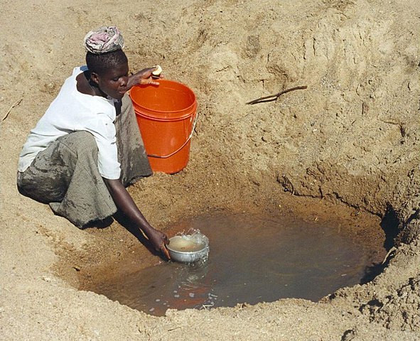
English: Mwamanongu Village water source, Tanzania. "In Meatu district, Shinyanga region, Tanzania, water most often comes from open holes dug in the sand of dry riverbeds, and it is invariably contaminated." .
Français : Point d'eau du village de Mwamanongu, en Tanzanie. "Dans le district de Meatu (région de Shinyanga, Tanzanie), L'eau provient le plus souvent de trous creusés dans le sable de lits de rivières asséchées. Elle est systématiquement contaminée." |
||
| Data | |||
| Origem |
http://solarcooking.wikia.com/wiki/Image:Mwamongu_water_source.jpg, |
||
| Autor | Bob Metcalf | ||
| Permissão (Reutilizar este ficheiro) |
|
| Localização da câmara | | Esta e outras imagens nas suas localizações em: OpenStreetMap |
|---|
Location note from author: If one goes north from the city of Tabora, follow it to Shinyanga. Shinyanga town is the administrative location of the Shinyanga Region, which includes several districts, Meatu District being one of them. From Shinyanga, go east to find the town of Mhunze, which I think is what I know as Mwanhuze, the District headquarters. It was from Mhunze that we took a Land Rover a bit northwest, I think, perhaps 15 km, to reach Mwamanongu. The driver knew how to get to these villages, but there were no road signs anywhere, nor any landmarks on the flat land, and the 'road' was just a path, often in lousy condition for the rare vehicle that would use it.
Editor's note: Mwanhuze and Mwamanongu are wards in en:Meatu District.[1] Meatu is a trapezoidal region that borders the western end of Lake Eyasi and extends roughly 70 km to the northwest.[2] Mhunze is a ward in en:Bariadi District. Walter Siegmund (talk) 05:02, 14 January 2008 (UTC)

|
Esta imagem foi avaliada de acordo com os critérios para imagens de valor e foi considerada a imagem de maior valor na Commons no domínio: Primitive water supply. Pode consultar o processo de nomeação em Commons:Candidatas a imagem de valor/Mwamongu water source.jpg. |
Histórico do ficheiro
Clique uma data e hora para ver o ficheiro tal como ele se encontrava nessa altura.
| Data e hora | Miniatura | Dimensões | Utilizador | Comentário | |
|---|---|---|---|---|---|
| atual | 23h39min de 12 de janeiro de 2008 | | 946 × 768 (344 kB) | Wsiegmund | PE; cropped white borders |
| 23h38min de 12 de janeiro de 2008 |  | 1 024 × 768 (149 kB) | Wsiegmund | Upload slightly larger version | |
| 14h58min de 12 de janeiro de 2008 |  | 944 × 704 (85 kB) | Wsiegmund | {{Information |Description=Mwamongu Village water source, Tanzania |Source=Wikia:c:solarcooking:Image:Mwamongu_water_source.jpg |Date=2006-06-06 |Author=Bob Metcalf |Permission={{PD-author|Bob Metcalf}} |other_versions= }} |
Utilização local do ficheiro
As seguintes 5 páginas usam este ficheiro:
Utilização global do ficheiro
As seguintes wikis usam este ficheiro:
- af.wikipedia.org
- ar.wikipedia.org
- ca.wikipedia.org
- da.wikipedia.org
- de.wikipedia.org
- de.wikibooks.org
- de.wiktionary.org
- el.wikipedia.org
- en.wikipedia.org
- en.wikibooks.org
- en.wikiversity.org
- en.wiktionary.org
- es.wikipedia.org
- eu.wikipedia.org
- fi.wikipedia.org
- fr.wikipedia.org
- fr.wiktionary.org
- ga.wikipedia.org
- gur.wikipedia.org
- he.wikipedia.org
- hi.wikipedia.org
- hu.wikibooks.org
- id.wikipedia.org
- ig.wikipedia.org
- io.wiktionary.org
- it.wikipedia.org
Ver mais utilizações globais deste ficheiro.