
Ficheiro:Noel 28 oct 2007 1530Z.jpg

Imagem numa resolução maior (6 000 × 7 800 píxeis, tamanho: 7,72 MB, tipo MIME: image/jpeg)
|
|
Esta imagem provém do Wikimedia Commons, um acervo de conteúdo livre da Wikimedia Foundation que pode ser utilizado por outros projetos.
|
Descrição do ficheiro
| Descrição |
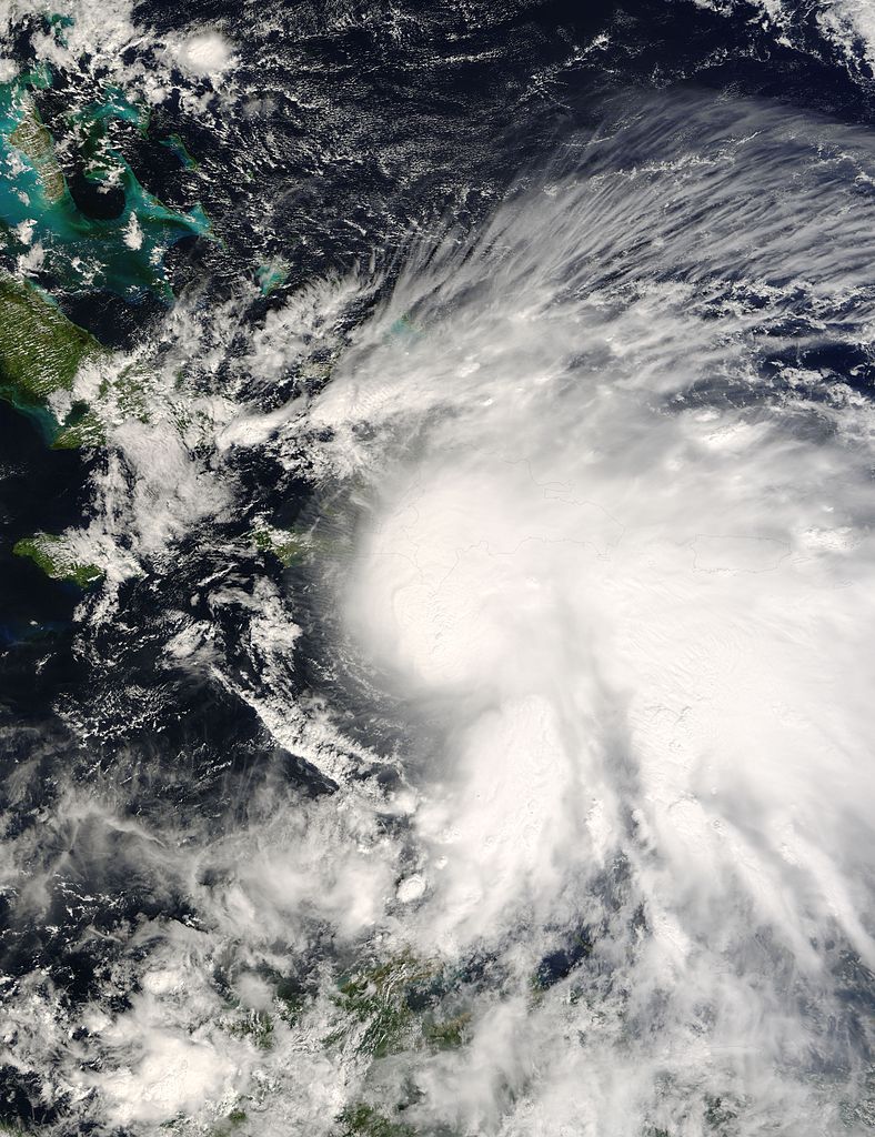
Tropical Depression 16 was intensifying into Tropical Storm Noel late in the morning of October 28, 2007, when the Moderate Resolution Imaging Spectroradiometer (MODIS) on NASA’s Terra satellite captured this image. Though still weak, the storm was beginning to take the distinct shape of a tropical cyclone. A dense circle of clouds converged over the Caribbean Sea just south of Haiti and the Dominican Republic, and a long tail of clouds curled over Puerto Rico. Shadows cast by towering thunderstorm clouds make the cloud layer appear to be boiling in places. At the time this image was acquired, Noel had winds of 65 kilometers per hour (40 miles per hour or 35 knots) with gusts to 83 km/hr (52 mph, 45 knots), said the National Hurricane Center. Despite relatively low wind speeds, the storm posed a serious threat to Hispaniola, the island encompassing the Dominican Republic and Haiti. The National Hurricane Center expected Noel to dump between 250 and 500 millimeters (10 and 20 inches) of rain on the island, with a few isolated areas receiving up to 760 mm (30 inches) of rain. The heavy rainfall has the potential to trigger deadly floods and mudslides. Tropical Storm Jeanne was just a tropical storm when its heavy rain caused extensive floods and mudslides that killed at least 1,500 Haitians in September 2004. Haiti is particularly vulnerable to flash flooding and landslides because of the widespread deforestation of its mountainous terrain. The large image provided above is at MODIS’ maximum resolution of 250 meters per pixel. The image is available in additional resolutions from the MODIS Rapid Response System. |
|||||
| Data | ||||||
| Origem | http://earthobservatory.nasa.gov/NaturalHazards/natural_hazards_v2.php3?img_id=14598 | |||||
| Autor | NASA image courtesy Jeff Schmaltz, MODIS Rapid Response Team at NASA GSFC | |||||
| Permissão (Reutilizar este ficheiro) |
|
|||||
| Outras versões | Image:Noel 28 oct 2007 1530Z sm.jpg |

Histórico do ficheiro
Clique uma data e hora para ver o ficheiro tal como ele se encontrava nessa altura.
| Data e hora | Miniatura | Dimensões | Utilizador | Comentário | |
|---|---|---|---|---|---|
| atual | 15h53min de 29 de outubro de 2007 | | 6 000 × 7 800 (7,72 MB) | Good kitty | == Summary == {{Information |Description=Tropical Storm Noel (16L) over Haiti and the Dominican Republic, as seen by the MODIS instrument aboard NASA's Terra satellite on October 28 at 1530 UTC. |Source=http://rapidfire.sci.gsfc.nasa.gov/gallery/?2007301- |
Utilização local do ficheiro
A seguinte página usa este ficheiro:
Utilização global do ficheiro
As seguintes wikis usam este ficheiro:
- de.wikipedia.org
- en.wikipedia.org
- fr.wikipedia.org
- id.wikipedia.org