
Ficheiro:Sandy 2012-10-29 1815Z.jpg

Imagem numa resolução maior (11 202 × 18 000 píxeis, tamanho: 67,73 MB, tipo MIME: image/jpeg)
|
|
Esta imagem provém do Wikimedia Commons, um acervo de conteúdo livre da Wikimedia Foundation que pode ser utilizado por outros projetos.
|
| Aviso | Alguns navegadores podem ter problemas ao exibir esta imagem em sua resolução máxima. Esta imagem tem um número excepcionalmente grande de píxeis e pode ou não carregar corretamente ou travar seu navegador. |
|---|
Descrição do ficheiro
| Descrição |
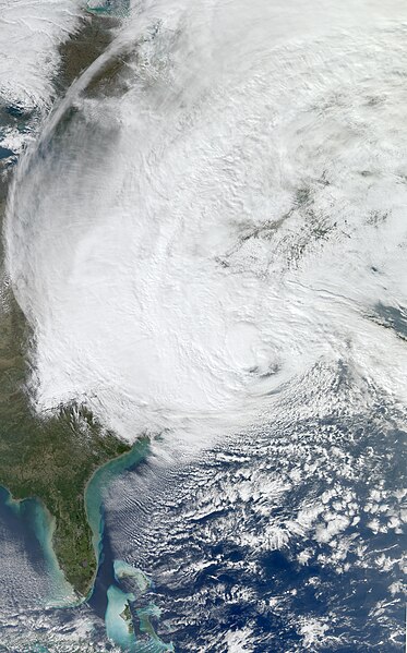
English: The Moderate Resolution Imaging Spectroradiometer (MODIS) on NASA’s Aqua satellite acquired this image of Hurricane Sandy at 2:20 p.m. Eastern Daylight Time (18:20 Universal Time) on October 29, 2012.
At 2:00 p.m. Eastern Daylight Time on October 29, the U.S. National Hurricane Center (NHC) reported that Hurricane Sandy was located about 110 miles (180 kilometers) southeast of Atlantic City, New Jersey, and about 175 miles (285 kilometers) south-southeast of New York City. The storm had maximum sustained winds of 90 miles (150 kilometers) per hour. The storm was moving toward the northwest at about 28 miles (44 kilometers) per hour. The NHC stated that Sandy could change into a wintertime low-pressure system later in the day, but cautioned that this would not weaken the storm prior to landfall. The NHC forecast that Hurricane Sandy would come ashore on the evening of October 29, along the coast of southern New Jersey or Delaware. The NHC warned of multiple hazards associated with the storm. Hurricane-force winds were predicted for the Mid-Atlantic States, including New York City, with tropical storm-force winds from Virginia to Canada. A storm surge, combined with astronomically high tides (at full Moon), promised to flood coastal areas with waters as much as 11 feet (3 meters) above normal. Sandy was forecast to drop as much as 8 inches (20 centimeters) of rain, and the mountains of Appalachia were expected to receive up to 3 feet (1 meter) of snow. The NHC urged potentially affected residents to consult their local National Weather Service forecast offices for more information. Government officials urged residents to heed evacuation warnings, and hundreds of thousands of people had fled their homes by October 29, CNN reported. More than 100,000 customers in seven states had already lost electrical power. In the days leading up to the storm, as residents stocked up on supplies and utility companies called in reinforcements from across the country, the U.S. Geological Survey deployed more than 150 storm-surge sensors along the Atlantic Coast to monitor Sandy’s effects in real time. |
| Data | |
| Origem | http://lance-modis.eosdis.nasa.gov/cgi-bin/imagery/realtime.cgi?date=2012303 |
| Autor | NASA, MODIS/ LANCE, HDF File Data processed by Supportstorm, Caption by Michon Scott |
| Outras versões |
.jpg) A cropped version is also available: File:Sandy Oct 29 2012 1815Z cropped.jpg A cropped version is also available: File:Sandy Oct 29 2012 1815Z cropped.jpg |
Licenciamento
| Este ficheiro está no domínio público nos Estados Unidos porque foi criado exclusivamente pela NASA. As orientações sobre o direito de autor da NASA são que «as obras da NASA não têm os direitos de autor protegidos salvo indicação em contrário». Veja Template:PD-USGov, as orientações sobre o direito de autor da NASA ou as normas de uso de imagens do Laboratório de Propulsão a Jato (Jet Propulsion Lab, JPL). | ||
 |
Avisos:
|
Histórico do ficheiro
Clique uma data e hora para ver o ficheiro tal como ele se encontrava nessa altura.
| Data e hora | Miniatura | Dimensões | Utilizador | Comentário | |
|---|---|---|---|---|---|
| atual | 01h41min de 30 de outubro de 2012 | | 11 202 × 18 000 (67,73 MB) | Supportstorm | {{Information |Description ={{en|1=At 2:00 p.m. Eastern Daylight Time on October 29, the U.S. National Hurricane Center (NHC) reported that Hurricane Sandy was located about 110 miles (180 kilometers) southeast of Atlantic City, New Jersey, and abou... |
Utilização local do ficheiro
As seguintes 2 páginas usam este ficheiro:
Utilização global do ficheiro
As seguintes wikis usam este ficheiro:
- ar.wikipedia.org
- az.wikipedia.org
- ca.wikipedia.org
- cy.wikipedia.org
- de.wikipedia.org
- en.wikipedia.org
- Chris Christie
- Lorenzo Langford
- Bounty (1960 ship)
- Hurricane Sandy
- Effects of Hurricane Sandy in New Jersey
- Effects of Hurricane Sandy in New York
- Effects of Hurricane Sandy in the Greater Antilles
- Template:Hurricane Sandy series
- Effects of Hurricane Sandy in New England
- Meteorological history of Hurricane Sandy
- Effects of Hurricane Sandy in Canada
- Effects of Hurricane Sandy in Maryland and Washington, D.C.
- John B. Caddell
- Hurricane Sandy: Coming Together
- Political impact of Hurricane Sandy
- Occupy Sandy
- 12-12-12: The Concert for Sandy Relief
- 2012–13 North American winter
- 14th Street Tunnel shutdown
- gl.wikipedia.org
- mr.wikipedia.org
- no.wikipedia.org
- tr.wikipedia.org