
Ficheiro:Brazilian States by Population density.svg

Dimensões desta antevisão em PNG do ficheiro SVG: 681 × 600 píxeis Outras resoluções: 273 × 240 píxeis | 545 × 480 píxeis | 872 × 768 píxeis | 1 163 × 1 024 píxeis | 2 325 × 2 048 píxeis | 780 × 687 píxeis.
Imagem numa resolução maior (ficheiro SVG, de 780 × 687 píxeis, tamanho: 641 kB)
|
|
Esta imagem provém do Wikimedia Commons, um acervo de conteúdo livre da Wikimedia Foundation que pode ser utilizado por outros projetos.
|
| This image was created / taken by João Felipe C.S. |
| Descrição |
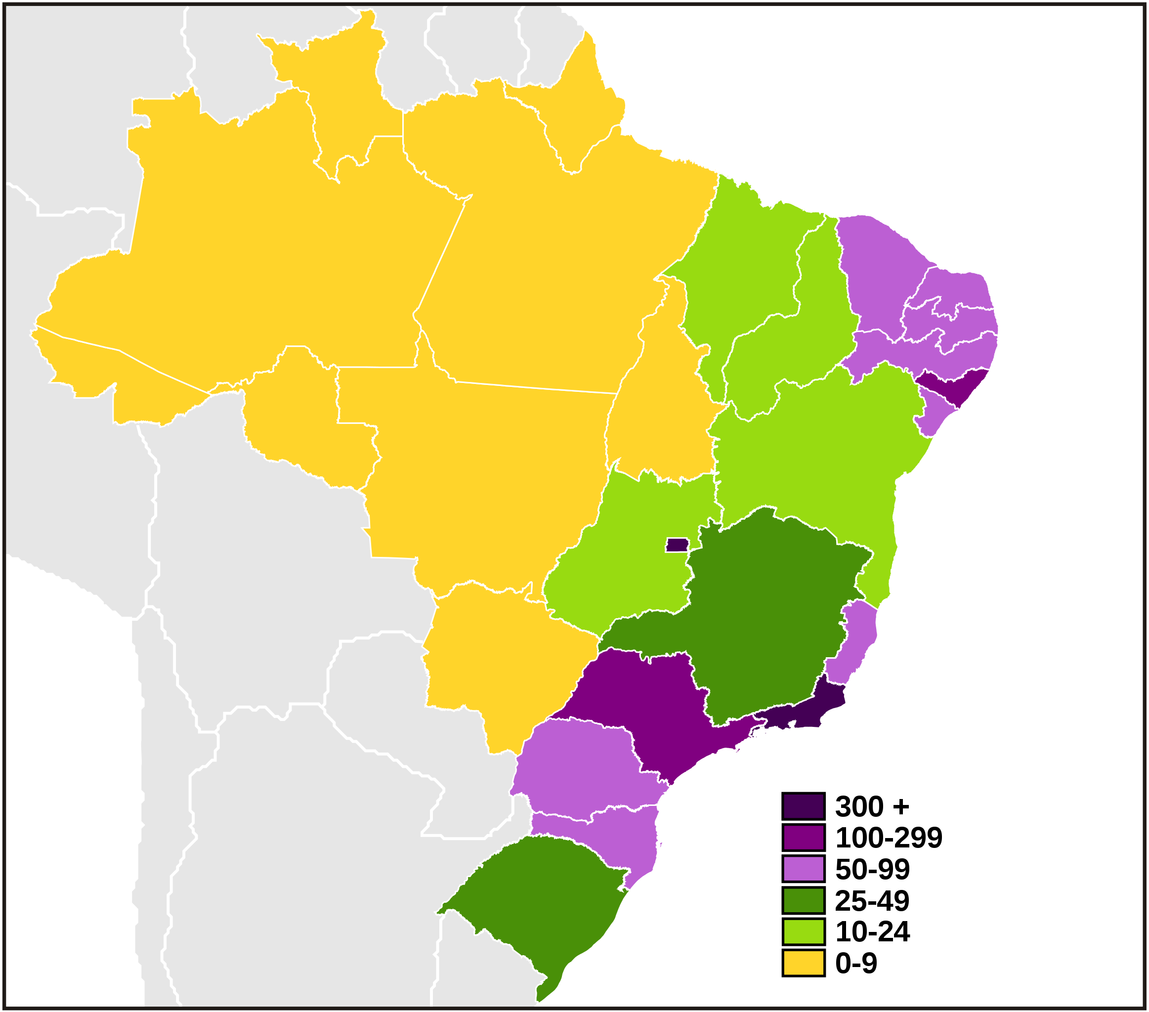
English: Map of Brazilian states by population density.
Português: Mapa dos estados brasileiros por densidade demográfica.
Este(a) desenho vetorial não especificado foi criado com o Inkscape . |
||||||||
| Data | |||||||||
| Origem | Obra do próprio | ||||||||
| Autor | Felipe Menegaz | ||||||||
| Permissão (Reutilizar este ficheiro) |
I, Felipe Menegaz, titular dos direitos de autor desta obra, publica-a com as seguintes licenças:
A utilização deste ficheiro é regulada nos termos da licença Creative Commons - Atribuição-CompartilhaIgual 2.5 Genérica, 2.0 Genérica e 1.0 Genérica. Atribuição: I, Felipe Menegaz
Pode escolher a licença que quiser. |
||||||||
| Outras versões |
|


Histórico do ficheiro
Clique uma data e hora para ver o ficheiro tal como ele se encontrava nessa altura.
| Data e hora | Miniatura | Dimensões | Utilizador | Comentário | |
|---|---|---|---|---|---|
| atual | 23h34min de 11 de junho de 2007 | | 780 × 687 (641 kB) | Felipe Menegaz | {{User:João Felipe C.S/by}} {{Information |Description= {{en|Map of Brazilian states by population density.}} {{pt|Mapa dos estados brasileiros por densidade demográfica.}} ---- {{Inkscape}} |Source= Own work |Date= June 7, 2007 |Author=[[User:João Fe |
| 03h25min de 8 de junho de 2007 |  | 780 × 687 (505 kB) | Felipe Menegaz | {{Information |Description= {{en|Map of Brazilian states by population density.}} {{pt|Mapa dos estados brasileiros por densidade demográfica.}} ---- {{Inkscape}} |Source= Own work |Date= June 7, 2007 |Author=João Felipe C.S |P | |
| 02h31min de 8 de junho de 2007 |  | 780 × 687 (505 kB) | Felipe Menegaz | {{Information |Description= {{en|Map of Brazilian states by population density.}} {{pt|Mapa dos estados brasileiros por densidade demográfica.}} ---- {{Inkscape}} |Source= Own work |Date= June 7, 2007 |Author=João Felipe C.S |P |
Utilização local do ficheiro
As seguintes 2 páginas usam este ficheiro:
Utilização global do ficheiro
As seguintes wikis usam este ficheiro:
- bg.wikipedia.org
- ca.wikipedia.org
- de.wikipedia.org
- en.wikipedia.org
- eo.wikipedia.org
- fi.wikipedia.org
- he.wikipedia.org
- hu.wikipedia.org
- is.wikipedia.org
- ka.wikipedia.org
- ko.wikipedia.org
- lt.wikipedia.org
- mk.wikipedia.org
- sr.wikipedia.org
- uk.wikipedia.org
- uz.wikipedia.org
- wuu.wikipedia.org
- zh.wikipedia.org