
Ficheiro:CasernesVigileII planrome la.png
Dimensões desta antevisão: 752 × 600 píxeis. Outras resoluções: 301 × 240 píxeis | 602 × 480 píxeis | 963 × 768 píxeis | 1 128 × 900 píxeis.
Imagem numa resolução maior (1 128 × 900 píxeis, tamanho: 88 kB, tipo MIME: image/png)
|
|
Esta imagem provém do Wikimedia Commons, um acervo de conteúdo livre da Wikimedia Foundation que pode ser utilizado por outros projetos.
|
Descrição do ficheiro
| Descrição |
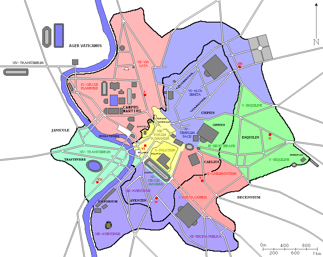
English: Administrative map of Rome redesigned from various sources. All important buildings built to the end of the Roman Empire as well as the regions of Augustus and the hills of Rome are drawn. In red, seven barracks of cohortes vigilium and their areas of influence.
Français : Plan administratif de Rome redessiné à partir de diverses sources. Tous les bâtiments importants construits jusqu'à la fin de l'Empire romain sont dessinés, ainsi que les régions d'Auguste et les collines de Rome. En rouge, les sept casernes de vigiles et leurs aires d'influence.
Magyar: Róma különböző források alapján megrajzolt közigazgatási térképe. A császárkor végére megépített fontosabb épületeket ábrázolja, továbbá Róma dombjait és az Augustus császár által kialakított regiókat. Vörössel jelezve a hét cohortes vigilium székhelye, felelősségi körzeteikkel. |
| Data | |
| Origem | Derivated from http://commons.wikimedia.org/wiki/File:CasernesVigileII_planrome.png |
| Autor | Fekist |
Licenciamento
Eu, titular dos direitos de autor desta obra, publico-a com as seguintes licenças:

|
É concedida permissão para copiar, distribuir e/ou modificar este documento nos termos da Licença de Documentação Livre GNU, versão 1.2 ou qualquer versão posterior publicada pela Free Software Foundation; sem Secções Invariantes, sem textos de Capa e sem textos de Contra-Capa. É incluída uma cópia da licença na secção intitulada GNU Free Documentation License. |
A utilização deste ficheiro é regulada nos termos da licença Creative Commons - Atribuição 3.0 Não Adaptada.
- Pode:
- partilhar – copiar, distribuir e transmitir a obra
- recombinar – criar obras derivadas
- De acordo com as seguintes condições:
- atribuição – Tem de fazer a devida atribuição da autoria, fornecer uma hiperligação para a licença e indicar se foram feitas alterações. Pode fazê-lo de qualquer forma razoável, mas não de forma a sugerir que o licenciador o apoia ou subscreve o seu uso da obra.
Pode escolher a licença que quiser.
Histórico do ficheiro
Clique uma data e hora para ver o ficheiro tal como ele se encontrava nessa altura.
| Data e hora | Miniatura | Dimensões | Utilizador | Comentário | |
|---|---|---|---|---|---|
| atual | 18h25min de 24 de julho de 2011 | | 1 128 × 900 (88 kB) | Fekist | {{Information |Description ={{en|1=Administrative map of Rome redesigned from various sources. All important buildings built to the end of the Roman Empire as well as the regions of Augustus and the hills of Rome are drawn. In red, seven barracks of '' |
Utilização local do ficheiro
As seguintes 2 páginas usam este ficheiro:
Utilização global do ficheiro
As seguintes wikis usam este ficheiro:
- ar.wikipedia.org
- en.wikipedia.org
- fi.wikipedia.org
- hu.wikipedia.org
- no.wikipedia.org
- sv.wikipedia.org