
Ficheiro:Earth Impact Database world map.svg

Dimensões desta antevisão em PNG do ficheiro SVG: 512 × 256 píxeis Outras resoluções: 320 × 160 píxeis | 640 × 320 píxeis | 1 024 × 512 píxeis | 1 280 × 640 píxeis | 2 560 × 1 280 píxeis.
Imagem numa resolução maior (ficheiro SVG, de 512 × 256 píxeis, tamanho: 351 kB)
|
|
Esta imagem provém do Wikimedia Commons, um acervo de conteúdo livre da Wikimedia Foundation que pode ser utilizado por outros projetos.
|
Descrição do ficheiro
| Descrição |
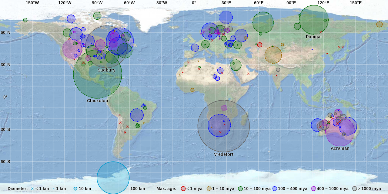
English: World map of craters on the Earth Impact Database by CMG Lee. Hover over or tap a circle or cross to highlight it and show its details. Background map is from https://earthquake.usgs.gov/learn/topics/plate_tectonics/majplatecolor.pdf and crater data is from http://passc.net/EarthImpactDatabase/. |
|
| Data | ||
| Origem |
|
|
| Autor | Cmglee, United States Geological Survey, Earth Impact Database |

Licenciamento
A utilização deste ficheiro é regulada nos termos da licença Creative Commons Atribuição-CompartilhaIgual 4.0 Internacional.
- Pode:
- partilhar – copiar, distribuir e transmitir a obra
- recombinar – criar obras derivadas
- De acordo com as seguintes condições:
- atribuição – Tem de fazer a devida atribuição da autoria, fornecer uma hiperligação para a licença e indicar se foram feitas alterações. Pode fazê-lo de qualquer forma razoável, mas não de forma a sugerir que o licenciador o apoia ou subscreve o seu uso da obra.
- partilha nos termos da mesma licença – Se remisturar, transformar ou ampliar o conteúdo, tem de distribuir as suas contribuições com a mesma licença ou uma licença compatível com a original.
Histórico do ficheiro
Clique uma data e hora para ver o ficheiro tal como ele se encontrava nessa altura.
| Data e hora | Miniatura | Dimensões | Utilizador | Comentário | |
|---|---|---|---|---|---|
| atual | 22h07min de 15 de julho de 2018 | | 512 × 256 (351 kB) | Cmglee | Support Safari on mobile iOS as per en:user_talk:Vincent_Mia_Edie_Verheyen#Email_questions. |
| 06h36min de 1 de dezembro de 2017 |  | 512 × 256 (359 kB) | Cmglee | Label more notable craters and right-align field labels. | |
| 20h53min de 13 de novembro de 2017 |  | 512 × 256 (345 kB) | Cmglee | Use text overlay instead of tooltips. | |
| 08h00min de 11 de novembro de 2017 |  | 512 × 256 (297 kB) | Cmglee | User created page with UploadWizard |
Utilização local do ficheiro
As seguintes 2 páginas usam este ficheiro:
Utilização global do ficheiro
As seguintes wikis usam este ficheiro:
- ca.wikipedia.org
- de.wikipedia.org
- en.wikipedia.org
- Impact crater
- Impact event
- List of impact structures on Earth
- Earth Impact Database
- User:Cmglee
- List of impact structures in Africa
- List of impact structures in Asia and Russia
- List of impact structures in Australia
- List of impact structures in Europe
- List of impact structures in North America
- List of impact structures in South America
- User:Kazkaskazkasako/Books/Physical sciences
- User:Cmglee/svg
- Template:Earth Impact Database world map.svg
- fa.wikipedia.org
- fr.wikipedia.org
- tr.wikipedia.org
- zh.wikipedia.org