
Ficheiro:Recife-Map1665.jpg

Imagem numa resolução maior (7 648 × 5 459 píxeis, tamanho: 7,33 MB, tipo MIME: image/jpeg)
|
|
Esta imagem provém do Wikimedia Commons, um acervo de conteúdo livre da Wikimedia Foundation que pode ser utilizado por outros projetos.
|
Descrição do ficheiro
| Descrição |
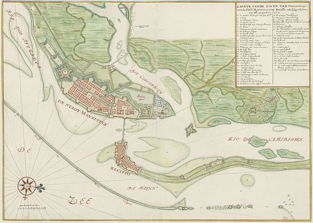
Nederlands: Caerte van de haven van Pharnambocque met de stadt Mouritius en het dorp Reciffe met bijleggende forten en alle gelegentheden van dien English: Watercolour chart of the city of Recife (Brazil) in the 17th century |
||||||||||||||||||||||
| Data | ca. 1665 | ||||||||||||||||||||||
| Origem | Nationaal Archief, 4.VELH inv.nr. 619.74 | ||||||||||||||||||||||
| Autor |
|
||||||||||||||||||||||
| Permissão (Reutilizar este ficheiro) |
|
||||||||||||||||||||||
Histórico do ficheiro
Clique uma data e hora para ver o ficheiro tal como ele se encontrava nessa altura.
| Data e hora | Miniatura | Dimensões | Utilizador | Comentário | |
|---|---|---|---|---|---|
| atual | 16h15min de 9 de dezembro de 2016 | | 7 648 × 5 459 (7,33 MB) | Sonty567 | Higher resolution |
| 16h21min de 13 de abril de 2012 |  | 1 280 × 916 (302 kB) | Fentener van Vlissingen | higher res, full image | |
| 02h47min de 29 de setembro de 2008 |  | 458 × 411 (151 kB) | Fulviusbsas | == Summary == {{Information |Description={{en|1=Watercolour chart of the city of Recife (Brazil) in the 17th century }} |Source=Vingboons Atlas (1665) |Author=unknown |Date=1665 |Permission={{PD-old}} |other_versions= }} <!--{{ImageUpload|full}}--> [[Cat | |
| 21h13min de 28 de setembro de 2008 |  | 458 × 457 (163 kB) | Fulviusbsas | {{Information |Description={{en|1=Watercolour chart of the city of Recife (Brazil) in the 17th century }} |Source=Vingboons Atlas (1665) |Author=unknown |Date=1665 |Permission={{PD-old}} |other_versions= }} <!--{{ImageUpload|full}}--> Category:Recife |
Utilização local do ficheiro
As seguintes 5 páginas usam este ficheiro:
Utilização global do ficheiro
As seguintes wikis usam este ficheiro:
- ca.wikipedia.org
- de.wikipedia.org
- en.wikipedia.org
- en.wikivoyage.org
- fr.wikipedia.org
- gl.wikipedia.org
- it.wikipedia.org
- nl.wikipedia.org
- ru.wikipedia.org
- uk.wikipedia.org
- www.wikidata.org