
Ficheiro:Warszawa Powstanie 1944-08-04.jpg

Dimensões desta antevisão: 483 × 600 píxeis. Outras resoluções: 193 × 240 píxeis | 387 × 480 píxeis | 619 × 768 píxeis | 825 × 1 024 píxeis | 1 600 × 1 986 píxeis.
Imagem numa resolução maior (1 600 × 1 986 píxeis, tamanho: 2,43 MB, tipo MIME: image/jpeg)
|
|
Esta imagem provém do Wikimedia Commons, um acervo de conteúdo livre da Wikimedia Foundation que pode ser utilizado por outros projetos.
|
Descrição do ficheiro
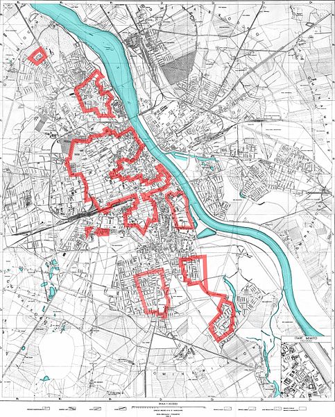
| Descrição | The areas of Warsaw controlled by the Home Army on August 4th, 1944, during the opening stages of the Warsaw Uprising. This map was based on a variety of sources and is generally accurate; greater accuracy cannot be obtained as there were no stable front-lines and the ones presented here are only for orientation. Also note that not all areas outside of the Polish zone of control were controlled by the Germans: in early August much of the city was still a no-man's-land (as was the case of Żoliborz that was abandoned on August 1, and then easily retaken by the Polish forces to retreat to Kampinos and return there) |
| Data | |
| Origem |
|
| Autor | Halibutt |
| Outras versões |
|
Licenciamento
Since the legal status of the above comment has been questioned, I hereby grant anyone the right to treat it as either a standard copyright notice, invariant section, legal statement, legal advice, friendly suggestion or a mere comment, depending on his or hers own choice. |
|

The following is a list of maps created by Halibutt and uploaded to commons, as well as their present and projected derivatives.
| Parent Image | Image | Description | |||||||||||
|---|---|---|---|---|---|---|---|---|---|---|---|---|---|
| Maps by Halibutt | |||||||||||||
| Image:Rzeczpospolita.png | Image:Rzeczpospolita.png | The Republic in 17th and 18th century | |||||||||||
| Image:Rzeczpospolita 1600.png | The Republic after the Treaty of Dywilino | ||||||||||||
| Image:Rzeczpospolita voivodships.png | Voivodships of The Republic | ||||||||||||
| Image:Rzeczpospolita_Potop.png | The Republic during The Deluge and Chmielnicki Uprising, with major battles of the era marked | ||||||||||||
| Magnates and their lands and domains | |||||||||||||
| 1st • 2nd • 3rd | Partitions of Poland | ||||||||||||
| War of the constitution | |||||||||||||
| Image:Rzeczpospolita.xcf | SOURCE FILE - GIMP format | ||||||||||||
| Image:Poland 1939.png | Image:Poland 1939.png | Poland in 1939 | |||||||||||
| Image:Dywizje wrzesien 1.png | Order of Battle on September 1st, during the Polish Defence War of 1939 | ||||||||||||
| Image:Poland 1939.xcf | SOURCE FILE - GIMP format | ||||||||||||
| Image:Polska kontur bialy.png | Image:Polska kontur bialy.png | Contour map of Poland AD 1999, for use with various locator maps | |||||||||||
| Image:Rzeczpospolita 1923.png | Image:Rzeczpospolita 1923.png | Map of Poland 1918-1939, currently under development | |||||||||||
| Image:PBW March 1919.png | Polish-Bolshevik War - fronts in March of 1919 | ||||||||||||
| Image:PBW December 1919.png | Polish-Bolshevik War - fronts in December of 1919 | ||||||||||||
| Image:PBW June 1920.png | Polish-Bolshevik War - fronts in July of 1920 | ||||||||||||
| Image:PBW August 1920.png | Polish-Bolshevik War - fronts in August of 1920 | ||||||||||||
| Polish Defence War of 1939 | |||||||||||||
| Polish areas annexed by Germany, Lithuania, Slovakia and the Soviet Union | |||||||||||||
| German concentration camps in Poland | |||||||||||||
| Curzon line | |||||||||||||
| Major battles of the Polish-Bolshevik War | |||||||||||||
| names • no names | Polish/Czechoslovak/Lithuanian/German/Ukrainian claims in 1920's | ||||||||||||
| Image:Rzeczpospolita Central Lithuania.png | Central Lithuania | ||||||||||||
| Image:Rzeczpospolita Lithuania claims.png | Central Lithuania as compared with other Lithuanian claims | ||||||||||||
| Image:Rzeczpospolita 1789-1920.png | Post-1922 borders compared with the territory of Poland before the partitions | ||||||||||||
| Warsaw Uprising and the Operation Tempest | |||||||||||||
| Poland partitioned between the Soviets and the Germans | |||||||||||||
| Image:Rzeczpospolita 1939 Polish divisions.png | Polish divisions on September 1, 1939 | ||||||||||||
| Home Army inspectorates | |||||||||||||
| Image:Rzeczpospolita 1922.xcf | SOURCE FILE - GIMP format | ||||||||||||
| Image:Rzeczpospolita 1937.svg | Vector version!!!! | layered version available on request | |||||||||||
Histórico do ficheiro
Clique uma data e hora para ver o ficheiro tal como ele se encontrava nessa altura.
| Data e hora | Miniatura | Dimensões | Utilizador | Comentário | |
|---|---|---|---|---|---|
| atual | 14h10min de 9 de maio de 2007 | | 1 600 × 1 986 (2,43 MB) | Halibutt | |
| 01h49min de 6 de maio de 2007 |  | 1 600 × 1 986 (1,08 MB) | Halibutt | {{Information |Description=The areas of Warsaw controlled by the Home Army on August 4th, 1944, during the opening stages of the Warsaw Uprising; map was based on a variety of sources and is pretty accurate, but don't expect any map to be any more or |
Utilização local do ficheiro
A seguinte página usa este ficheiro:
Utilização global do ficheiro
As seguintes wikis usam este ficheiro:
- af.wikipedia.org
- ar.wikipedia.org
- arz.wikipedia.org
- azb.wikipedia.org
- az.wikipedia.org
- be-tarask.wikipedia.org
- be.wikipedia.org
- cs.wikipedia.org
- de.wikipedia.org
- el.wikipedia.org
- fa.wikipedia.org
- fi.wikipedia.org
- he.wikipedia.org
- hu.wikipedia.org
- ia.wikipedia.org
- it.wikipedia.org
- ja.wikipedia.org
- lt.wikipedia.org
- lv.wikipedia.org
- nl.wikipedia.org
- no.wikipedia.org
- pl.wikipedia.org
- ro.wikipedia.org
- ru.wikipedia.org
- simple.wikipedia.org
- sk.wikipedia.org
- sl.wikipedia.org
- sr.wikipedia.org
- sv.wikipedia.org
- uk.wikipedia.org
- www.wikidata.org