
Ficheiro:Map of the Kingdom of Galicia, 1914.jpg
Sem resolução maior disponível.
Map_of_the_Kingdom_of_Galicia,_1914.jpg (598 × 450 píxeis, tamanho: 157 kB, tipo MIME: image/jpeg)
|
|
Esta imagem provém do Wikimedia Commons, um acervo de conteúdo livre da Wikimedia Foundation que pode ser utilizado por outros projetos.
|
{{DVG|== Descrição do ficheiro ==
| Descrição |
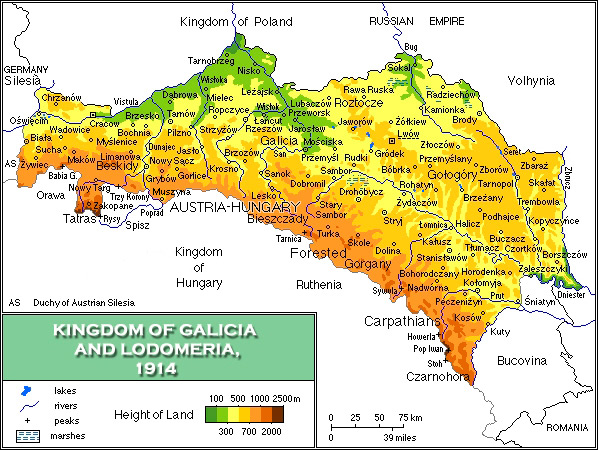
English: Map of the Kingdom of Galicia, 1914/Mapa fizyczna Galicji 1846-1918 |
| Data | |
| Origem | Obra do próprio |
| Autor | Mariusz Paździora |
| Outras versões | image:Galicia physical1914-de.png German |

|
Esta imagem de historical map (ou todas as imagens neste artigo ou categoria) deveriam ser recriadas usando gráficos vectoriais, como ficheiros SVG. Isto tem várias vantagens; veja as Commons:Media for cleanup|imagens para rever para mais informações. Se já criou um ficheiro SVG desta imagem, por favor, carregue-o. Depois do novo ficheiro SVG ter sido carregado, substitua aqui esta predefinição pela predefinição {{vector version available|nome da nova imagem.svg}}.
|


Licenciamento
Eu, titular dos direitos de autor desta obra, publico-a com a seguinte licença:
A utilização deste ficheiro é regulada nos termos da licença Creative Commons - Atribuição 3.0 Não Adaptada.
- Pode:
- partilhar – copiar, distribuir e transmitir a obra
- recombinar – criar obras derivadas
- De acordo com as seguintes condições:
- atribuição – Tem de fazer a devida atribuição da autoria, fornecer uma hiperligação para a licença e indicar se foram feitas alterações. Pode fazê-lo de qualquer forma razoável, mas não de forma a sugerir que o licenciador o apoia ou subscreve o seu uso da obra.
Histórico do ficheiro
Clique uma data e hora para ver o ficheiro tal como ele se encontrava nessa altura.
| Data e hora | Miniatura | Dimensões | Utilizador | Comentário | |
|---|---|---|---|---|---|
| atual | 07h13min de 9 de novembro de 2021 | | 598 × 450 (157 kB) | Alphathon | Corrected Bukovinan and Romanian borders |
| 09h02min de 10 de março de 2020 |  | 598 × 450 (310 kB) | Claude Zygiel | Kingdom of Poland was a part of the Russian Empire, kingdom of Hungary was a part of Austria-Hungary, and Galicia, Bucovina and Austrian Silesia were lands of the Austrian part. | |
| 18h40min de 18 de maio de 2011 |  | 598 × 450 (193 kB) | VT | - Slovakia was not present then - Austria-Hungary was changed to Kingdom of Hungary: as the map shows several parts of Austro-Hungarian Monarchy, even Galicia, Bukovina and Austrian Silesia were the parts of it, not just Hungary. | |
| 18h01min de 2 de abril de 2008 |  | 598 × 450 (343 kB) | Kiejstut9 | {{Information |Description=Map of the Kingdom of Galicia, 1914 |Source=self-made |Date=2008 |Author= Kiejstut9 |Permission= |other_versions= }} |
Utilização local do ficheiro
As seguintes 2 páginas usam este ficheiro:
Utilização global do ficheiro
As seguintes wikis usam este ficheiro:
- bg.wikipedia.org
- ca.wikipedia.org
- da.wikipedia.org
- de.wikipedia.org
- el.wikipedia.org
- en.wikipedia.org
- es.wikipedia.org
- et.wikipedia.org
- eu.wiktionary.org
- fa.wikipedia.org
- fr.wikipedia.org
- gl.wikipedia.org
- he.wikipedia.org
- hu.wikipedia.org
- it.wikipedia.org
- ja.wikipedia.org
- la.wikipedia.org
- mk.wikipedia.org
- nl.wikipedia.org
- nn.wikipedia.org
- no.wikipedia.org
- pl.wikipedia.org
- pl.wiktionary.org
- ro.wikipedia.org
- scn.wikipedia.org
- sh.wikipedia.org
- sl.wikipedia.org
- sr.wikipedia.org
- sv.wikipedia.org
- yi.wikipedia.org
- zh.wikipedia.org