
Ficheiro:Ain al-Assad air base, 8 jan 2020.png

Dimensões desta antevisão: 800 × 453 píxeis. Outras resoluções: 320 × 181 píxeis | 640 × 362 píxeis | 1 024 × 580 píxeis | 1 280 × 724 píxeis | 2 000 × 1 132 píxeis.
Imagem numa resolução maior (2 000 × 1 132 píxeis, tamanho: 4,5 MB, tipo MIME: image/png)
|
|
Esta imagem provém do Wikimedia Commons, um acervo de conteúdo livre da Wikimedia Foundation que pode ser utilizado por outros projetos.
|
Descrição do ficheiro
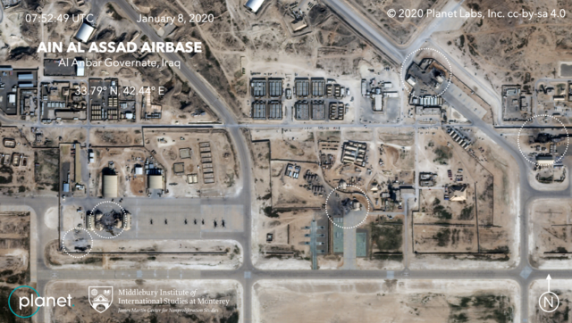
| Descrição | Satellite image, showing the damage to at least five structures at Ain al-Assad air base in Iraq in a series of precision missile strikes launched by Iran |
| Data | |
| Origem |
First upload: Brumfiel, Geoff; Welna, David (8 January 2020). Satellite Photos Reveal Extent Of Damage From Iranian Strike On Air Base In Iraq. NPR. Current upload: Garger, Kenneth (8 January 2020). Before-and-after satellite images show damage to Iraqi base hit by Iran. New York Post. |
| Autor | Planet Labs, Inc. / Middlebury Institute of International Studies at Monterey |
| Permissão (Reutilizar este ficheiro) |
There is a copyright notice in the upper right of this image. "© 2020 Planet Labs, Inc. cc-by-sa 4.0" |
Licenciamento
A utilização deste ficheiro é regulada nos termos da licença Creative Commons Atribuição-CompartilhaIgual 4.0 Internacional.
Atribuição: Planet Labs, Inc.
- Pode:
- partilhar – copiar, distribuir e transmitir a obra
- recombinar – criar obras derivadas
- De acordo com as seguintes condições:
- atribuição – Tem de fazer a devida atribuição da autoria, fornecer uma hiperligação para a licença e indicar se foram feitas alterações. Pode fazê-lo de qualquer forma razoável, mas não de forma a sugerir que o licenciador o apoia ou subscreve o seu uso da obra.
- partilha nos termos da mesma licença – Se remisturar, transformar ou ampliar o conteúdo, tem de distribuir as suas contribuições com a mesma licença ou uma licença compatível com a original.
Este ficheiro, originalmente carregado no site several sites but with watermark saying "© 2020 Planet Labs, Inc. cc-by-sa 4.0", foi revisto em 29 de fevereiro de 2020 pelo administrador ou revisor MGA73, que confirmou que o ficheiro estava disponível naquela data com a licença especificada.
|
Histórico do ficheiro
Clique uma data e hora para ver o ficheiro tal como ele se encontrava nessa altura.
| Data e hora | Miniatura | Dimensões | Utilizador | Comentário | |
|---|---|---|---|---|---|
| atual | 06h14min de 9 de janeiro de 2020 | | 2 000 × 1 132 (4,5 MB) | EnchanterTim | Higher resolution from: https://nypost.com/2020/01/08/before-and-after-satellite-images-show-damage-to-iraqi-base-hit-by-iran/ |
| 19h52min de 8 de janeiro de 2020 |  | 800 × 449 (805 kB) | Cold Season | {{Information |Description= Satellite image, showing the damage to at least five hangars and buildings at Ain al-Assad air base in Iraq in a series of precision missile strikes launched by Iran |Source= [https://www.npr.org/2020/01/08/794517031/satellite-photos-reveal-extent-of-damage-at-al-assad-air-base?t=1578512699906 Satellite Photos Reveal Extent Of Damage From Iranian Strike On Air Base In Iraq]. NPR. |Date= 8 January 2020 |Author= Planet Labs Inc./Middlebury Institute |Permission= |ot... |
Utilização local do ficheiro
A seguinte página usa este ficheiro:
Utilização global do ficheiro
As seguintes wikis usam este ficheiro:
- ar.wikipedia.org
- be.wikipedia.org
- ca.wikipedia.org
- ckb.wikipedia.org
- en.wikipedia.org
- es.wikipedia.org
- fa.wikipedia.org
- fi.wikipedia.org
- fr.wikipedia.org
- he.wikipedia.org
- id.wikipedia.org
- ja.wikipedia.org
- ka.wikipedia.org
- ko.wikipedia.org
- nl.wikipedia.org
- nl.wikinews.org
- pnb.wikipedia.org
- ru.wikipedia.org
- ru.wikinews.org
- so.wikipedia.org
- uk.wikipedia.org
- ur.wikipedia.org
- vi.wikipedia.org
- www.wikidata.org
- zh.wikipedia.org