
Ficheiro:Approximate extension of Alodia based on accounts of Ibn Hawqal.png

Dimensões desta antevisão: 800 × 581 píxeis. Outras resoluções: 320 × 232 píxeis | 640 × 464 píxeis | 813 × 590 píxeis.
Imagem numa resolução maior (813 × 590 píxeis, tamanho: 106 kB, tipo MIME: image/png)
|
|
Esta imagem provém do Wikimedia Commons, um acervo de conteúdo livre da Wikimedia Foundation que pode ser utilizado por outros projetos.
|
Descrição do ficheiro
| Descrição |
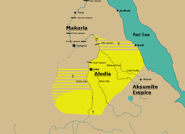
English: Initially based on map IX from the book "The Kingdom of Alwa" (see the first four versions of the map to see the faithful copy).[1] The original map had several problems, so I decided to modify it. 1) Zarroug had Alodia extend as far west as Darfur. However, there is still virtually no archaeological evidence supporting this assumption.[2] 2) The exact nothern border is still desputed; it is generally placed between Abu Hamad and the confluence of the Nile and the Atbara.[3] 3) Zarroug shows all regions west of the Nile as part of Alodia. However, the traveller Ibn Hawqal explicitly stated that parts of the region west of the White Nile were part of Makuria. The Nuba mountains were probably part of Alodia, hence I included stripes and a question mark for the area between the confluence of the two Niles and the Nuba mountains.[4] 4) There is little evidence that the Bayuda desert (between ed Debba and Omdurman) was part of either Makuria or Alodia.[5]
|
| Data | |
| Origem | Obra do próprio |
| Autor | LeGabrie |
Licenciamento
Eu, titular dos direitos de autor desta obra, publico-a com a seguinte licença:
A utilização deste ficheiro é regulada nos termos da licença Creative Commons Atribuição-CompartilhaIgual 4.0 Internacional.
- Pode:
- partilhar – copiar, distribuir e transmitir a obra
- recombinar – criar obras derivadas
- De acordo com as seguintes condições:
- atribuição – Tem de fazer a devida atribuição da autoria, fornecer uma hiperligação para a licença e indicar se foram feitas alterações. Pode fazê-lo de qualquer forma razoável, mas não de forma a sugerir que o licenciador o apoia ou subscreve o seu uso da obra.
- partilha nos termos da mesma licença – Se remisturar, transformar ou ampliar o conteúdo, tem de distribuir as suas contribuições com a mesma licença ou uma licença compatível com a original.
Histórico do ficheiro
Clique uma data e hora para ver o ficheiro tal como ele se encontrava nessa altura.
| Data e hora | Miniatura | Dimensões | Utilizador | Comentário | |
|---|---|---|---|---|---|
| atual | 15h20min de 27 de novembro de 2018 | | 813 × 590 (106 kB) | LeGabrie | Deleted stripes in Bayuda desert |
| 15h47min de 28 de outubro de 2018 |  | 703 × 590 (114 kB) | LeGabrie | decreased width | |
| 12h51min de 15 de outubro de 2018 |  | 813 × 590 (108 kB) | LeGabrie | Added Gash Delta | |
| 11h38min de 29 de setembro de 2018 |  | 813 × 590 (108 kB) | LeGabrie | Extended the beams over the entire Bayuda | |
| 12h12min de 4 de setembro de 2018 |  | 813 × 590 (111 kB) | LeGabrie | added question mark | |
| 11h59min de 4 de setembro de 2018 |  | 813 × 590 (108 kB) | LeGabrie | Cut the beams in Darfur | |
| 00h55min de 1 de setembro de 2018 |  | 813 × 590 (114 kB) | LeGabrie | Increased script size | |
| 00h51min de 1 de setembro de 2018 |  | 813 × 590 (114 kB) | LeGabrie | small fix | |
| 00h49min de 1 de setembro de 2018 |  | 813 × 590 (114 kB) | LeGabrie | Made it prettier | |
| 21h14min de 1 de fevereiro de 2018 |  | 813 × 590 (155 kB) | LeGabrie | Added white beams and question marks to highlight the uncertainties of Zarroug's map. These uncertainties are: The extension into Darfur,the question of ownership of northern Kordofan and the beginning of Al-Abwab. The concrete amount of desert aside o... |
Utilização local do ficheiro
As seguintes 5 páginas usam este ficheiro:
Utilização global do ficheiro
As seguintes wikis usam este ficheiro:
- ar.wikipedia.org
- arz.wikipedia.org
- azb.wikipedia.org
- cs.wikipedia.org
- de.wikipedia.org
- en.wikipedia.org
- fa.wikipedia.org
- fi.wikipedia.org
- fr.wikipedia.org
- id.wikipedia.org
- ms.wikipedia.org
- nl.wikipedia.org
- ru.wikipedia.org
- sl.wikipedia.org
- sr.wikipedia.org
- sv.wikipedia.org
- ta.wikipedia.org
- th.wikipedia.org
- tl.wikipedia.org
- uk.wikipedia.org
- vi.wikipedia.org
- zh.wikipedia.org