Ficheiro:Aster newyorkcity lrg.jpg

Dimensões desta antevisão: 452 × 600 píxeis. Outras resoluções: 181 × 240 píxeis | 361 × 480 píxeis | 578 × 768 píxeis | 771 × 1 024 píxeis | 1 964 × 2 607 píxeis.
Imagem numa resolução maior (1 964 × 2 607 píxeis, tamanho: 3,31 MB, tipo MIME: image/jpeg)
Histórico do ficheiro
Clique uma data e hora para ver o ficheiro tal como ele se encontrava nessa altura.
| Data e hora | Miniatura | Dimensões | Utilizador | Comentário | |
|---|---|---|---|---|---|
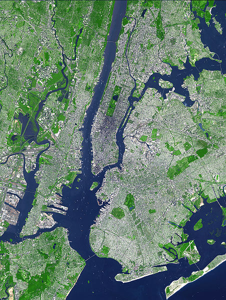
| atual | 18h54min de 8 de agosto de 2007 |  | 1 964 × 2 607 (3,31 MB) | HenrikRomby | {{Information |Description=This false-color satellite image shows Greater New York City. The Island of Manhattan juts southward from top center, bordered by the Hudson River to the west and the East River to the east (north is straight up in this scene.) |
Utilização local do ficheiro
A seguinte página usa este ficheiro:
Utilização global do ficheiro
As seguintes wikis usam este ficheiro:
- af.wikipedia.org
- ar.wikipedia.org
- ast.wikipedia.org
- bn.wikipedia.org
- ca.wikipedia.org
- da.wikipedia.org
- de.wikipedia.org
- el.wikipedia.org
- en.wikipedia.org
- Topography
- Hudson County, New Jersey
- User:TimAlderson/Userboxes
- Hudson Waterfront
- List of bridges, tunnels, and cuts in Hudson County, New Jersey
- User:NYCRuss/Sandbox/New York City
- Trees of New York City
- Talk:Trees of New York City
- Wikipedia:WikiProject New York City/Environment Task Force
- Wikipedia:WikiProject New York City/400 Task Force
- en.wikibooks.org
- eo.wikipedia.org
- es.wikipedia.org
- et.wikipedia.org
- fi.wikipedia.org
- fr.wikipedia.org
- fr.wikinews.org
- gl.wikipedia.org
- he.wikipedia.org
- hr.wikipedia.org
- hu.wikipedia.org
- hy.wikipedia.org
- id.wikipedia.org
- it.wikipedia.org
- ja.wikipedia.org
Ver mais utilizações globais deste ficheiro.


