Ficheiro:Breakup of Yugoslavia.gif
O conteúdo da página não é suportado noutras línguas.
Origem: Wikipédia, a enciclopédia livre.

Imagem numa resolução maior(1 545 × 1 242 píxeis, tamanho: 187 kB, tipo MIME: image/gif, cíclico, 14 quadros, 44 s)

This image could be re-created using vector graphics as an SVG file. This has several advantages; see Commons:Media for cleanup for more information. If an SVG form of this image is available, please upload it and afterwards replace this template with {{vector version available|new image name}}. It is recommended to name the SVG file "Breakup of Yugoslavia.svg" - then the template Vector version available (or Vva) does not need the new image name parameter.

Descrição do ficheiro

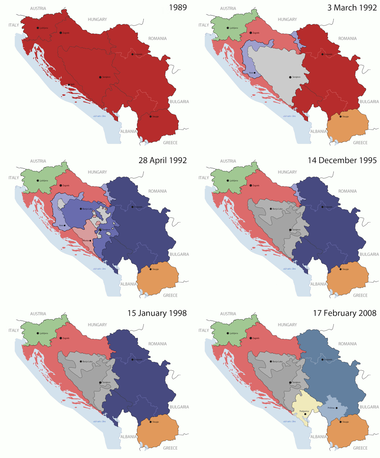
Key:

Yugoslavia (1943–1992) SFR Yugoslavia
Croatia (1991–present) Croatia
Herzeg-Bosnia (1992–1994)
UNTAES (1996–1998)
Federal Republic of Yugoslavia / Serbia and Montenegro (1992–2006) Serbia and Montenegro
Republika Srpska (1992–present) Republika Srpska
Serbian Krajina (1991–1995/96)
Republic of Bosnia and Herzegovina (1992–1995)
Bosnia and Herzegovina (1998–present) Bosnia and Herzegovina
Western Bosnia (1993–1995)
Serbia (2006–present) Serbia
Kosovo (under UNMIK control 1999–present; declaration of independence 2008) Kosovo
Montenegro (2006–present) Montenegro
Macedonia (1991–present) Macedonia
Slovenia (1991–present) Slovenia


Descrição

This is an animated GIF that shows the stages of the breakup of the SFR Yugoslavia in the 90's and 2000's. The map based off Morwen's map of the divisions of the SFRY, Which is licensed by the GFDL. The source for the dates of independence is the CIA World Factbook. These maps do not now show the Inter-Entity Boundary Line (IEBL) and/or the entities that are separated by it. The IEBL has been drawn based on this CIA map; the Brčko District has been drawn based on Image:BH municipality location.gif, by user:Ante Perkovic. I might add them in the future.

Since the original map was GFDL, this image is as well.

A map depicting Kosovo's final status is ready once it takes effect.


Changelog for versions 2/3:

Here are some changes in this new build of the map:

  • The Kosovo boundary has been given a shade of red instead of the previous UN blue since they are a province of Serbia under UNIMIK control.
  • Montenegro's color has been changed to a golden shade close to what's on the flag.
  • The IEBL and the Brčko District has been redrawn because I deleted the original map; the color for the Republika Srpska is lighter.
  • The dates are at the top left hand corner of the map instead of the bottom.
  • I have taken a new approach as to the boundaries. Each part of Yugoslavia now shows the boundary on the maps starting the year they broke away. I feel this change helps readers understand the breakup better.
  • The SFRY and the FRY are in different shades since the FRY was never accepted as the successor to the former by the UN.
  • The colors for the entities of BiH have been removed as to not confuse people into thinking that they are independent states. What remains is the IEBL with both entities in green.
  • The Kosovo boundary is finally in hash marks!
  • The Brčko District has been removed. The sale is too small to show accurately.

Changelog for version 4:

  • The map is larger!
  • The image has been rebuilt to include the eastern part of FYR Macedonia.
  • The image has been updated to take in Kosovo's new status.
  • The IEBL is now a darker line.
  • Montenegro, Kosovo, and FRY/SCG/Serbia have new colors!

Changelog for version 5:

  • Rebuilt
  • Larger map: size of base image
  • Accurate Inter-Entity Boundary Line
Data 24 July 2006 (orginal upload date)
Origem Made by Hoshie; see above for more details on sources.
Autor Hoshie
Outras versões

Licenciamento

GNU head É concedida permissão para copiar, distribuir e/ou modificar este documento nos termos da Licença de Documentação Livre GNU, versão 1.2 ou qualquer versão posterior publicada pela Free Software Foundation; sem Secções Invariantes, sem textos de Capa e sem textos de Contra-Capa. É incluída uma cópia da licença na secção intitulada GNU Free Documentation License.
w:pt:Creative Commons
atribuição partilha nos termos da mesma licença
A utilização deste ficheiro é regulada nos termos da licença Creative Commons - Atribuição-CompartilhaIgual 3.0 Não Adaptada.
Pode:
  • partilhar – copiar, distribuir e transmitir a obra
  • recombinar – criar obras derivadas
De acordo com as seguintes condições:
  • atribuição – Tem de fazer a devida atribuição da autoria, fornecer uma hiperligação para a licença e indicar se foram feitas alterações. Pode fazê-lo de qualquer forma razoável, mas não de forma a sugerir que o licenciador o apoia ou subscreve o seu uso da obra.
  • partilha nos termos da mesma licença – Se remisturar, transformar ou ampliar o conteúdo, tem de distribuir as suas contribuições com a mesma licença ou uma licença compatível com a original.
Esta marca de licenciamento foi adicionada a este ficheiro durante a atualização da licença GFDL.

Legendas

Adicione uma explicação de uma linha do que este ficheiro representa

Elementos retratados neste ficheiro

retrata

05ca2aefea8406b809968643552d5095c847a42f

191 625 byte

44 segundo

1 242 pixel

1 545 pixel

Histórico do ficheiro

Clique uma data e hora para ver o ficheiro tal como ele se encontrava nessa altura.

(Mais recentes | Mais antigas) Ver (10 posteriores | ) (10 | 20 | 50 | 100 | 250 | 500)
Data e horaMiniaturaDimensõesUtilizadorComentário
atual07h40min de 17 de julho de 2016Miniatura da versão das 07h40min de 17 de julho de 20161 545 × 1 242 (187 kB)מפתח-רשימהReverted to version as of 17:22, 21 August 2015 (UTC)
17h22min de 21 de agosto de 2015Miniatura da versão das 17h22min de 21 de agosto de 20151 463 × 1 158 (1,81 MB)BraganzaReverted to version as of 03:57, 19 January 2010
17h22min de 21 de agosto de 2015Miniatura da versão das 17h22min de 21 de agosto de 20151 545 × 1 242 (187 kB)BraganzaReverted to version as of 01:02, 19 December 2011
17h15min de 21 de agosto de 2015Miniatura da versão das 17h15min de 21 de agosto de 2015120 × 95 (3 kB)Braganza03:57, 19. Jan. 2010
01h02min de 19 de dezembro de 2011Miniatura da versão das 01h02min de 19 de dezembro de 20111 545 × 1 242 (187 kB)DIREKTORAdded details
18h09min de 27 de julho de 2011Miniatura da versão das 18h09min de 27 de julho de 20111 545 × 1 242 (170 kB)DIREKTORSmall fixes
17h28min de 27 de julho de 2011Miniatura da versão das 17h28min de 27 de julho de 20111 545 × 1 242 (171 kB)DIREKTORAdded UNMIK
16h38min de 27 de julho de 2011Miniatura da versão das 16h38min de 27 de julho de 20111 545 × 1 242 (165 kB)DIREKTORDates for the last two frames.
12h10min de 27 de julho de 2011Miniatura da versão das 12h10min de 27 de julho de 20111 545 × 1 242 (149 kB)DIREKTORLighter shade for country names
16h59min de 26 de julho de 2011Miniatura da versão das 16h59min de 26 de julho de 20111 545 × 1 242 (170 kB)DIREKTORHigher res plus details
(Mais recentes | Mais antigas) Ver (10 posteriores | ) (10 | 20 | 50 | 100 | 250 | 500)

As seguintes 2 páginas usam este ficheiro:

Utilização global do ficheiro

As seguintes wikis usam este ficheiro:

Ver mais utilizações globais deste ficheiro.

Metadados