
Ficheiro:Cumulonimbus Cloud over Africa (color).jpg

Imagem numa resolução maior (3 032 × 2 008 píxeis, tamanho: 3,1 MB, tipo MIME: image/jpeg)
|
|
Esta imagem provém do Wikimedia Commons, um acervo de conteúdo livre da Wikimedia Foundation que pode ser utilizado por outros projetos.
|
.jpg)
Descrição do ficheiro
| Descrição |
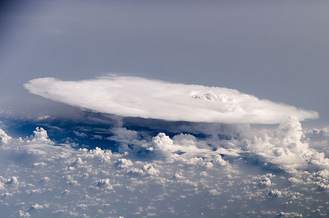
English: Perhaps the most impressive of cloud formations, cumulonimbus (from the Latin for “pile” and “rain cloud”) clouds form due to vigorous convection (rising and overturning) of warm, moist, and unstable air. Surface air is warmed by the Sun-heated ground surface and rises; if sufficient atmospheric moisture is present, water droplets will condense as the air mass encounters cooler air at higher altitudes. The air mass itself also expands and cools as it rises due to decreasing atmospheric pressure, a process known as adiabatic cooling. This type of convection is common in tropical latitudes year-round and during the summer season at higher latitudes.
As water in the rising air mass condenses and changes from a gas to a liquid state, it releases energy to its surroundings, further heating the surrounding air and leading to more convection and rising of the cloud mass to higher altitudes. This leads to the characteristic vertical “towers” associated with cumulonimbus clouds, an excellent example of which is visible in this astronaut photograph. If enough moisture is present to condense and heat the cloud mass through several convective cycles, a tower can rise to altitudes of approximately 10 kilometers at high latitudes and to 20 kilometers in the tropics before encountering a region of the atmosphere known as the tropopause—the boundary between the troposphere and the stratosphere. The tropopause is characterized by a strong temperature inversion. Beyond the tropopause, the air no longer gets colder as altitude increases. The tropopause halts further upward motion of the cloud mass. The cloud tops flatten and spread into an anvil shape, as illustrated by this astronaut photograph. The photo was taken from a viewpoint that was at an angle from the vertical, rather than looking straight down towards the Earth’s surface. The image, taken while the International Space Station was located over western Africa near the Senegal-Mali border, shows a fully formed anvil cloud with numerous smaller cumulonimbus towers rising near it. The high energy levels of these storm systems typically make them hazardous due to associated heavy precipitation, lightning, high wind speeds and possible tornadoes.
|
||||||||||||||||||||||||||||||||||||||||||||
| Data | |||||||||||||||||||||||||||||||||||||||||||||
| Origem | jsc.nasa.gov | ||||||||||||||||||||||||||||||||||||||||||||
| Autor | NASA/ISS 16 | ||||||||||||||||||||||||||||||||||||||||||||
| Esta é uma imagem retocada, o que significa que a versão original foi alterada digitalmente. Modificações: Worked with original .dcr Kodak raw image file; increased contrast, desaturate blues and purples, remove lens spots. Modificações feitas por Keraunoscopia. O original pode ser encontrado aqui: http://eol.jsc.nasa.gov/scripts/sseop/photo.pl?mission=ISS016&roll=E&frame=27426.
|
Licenciamento
| Este ficheiro está no domínio público nos Estados Unidos porque foi criado exclusivamente pela NASA. As orientações sobre o direito de autor da NASA são que «as obras da NASA não têm os direitos de autor protegidos salvo indicação em contrário». Veja Template:PD-USGov, as orientações sobre o direito de autor da NASA ou as normas de uso de imagens do Laboratório de Propulsão a Jato (Jet Propulsion Lab, JPL). | ||
 |
Avisos:
|
Histórico do ficheiro
Clique uma data e hora para ver o ficheiro tal como ele se encontrava nessa altura.
| Data e hora | Miniatura | Dimensões | Utilizador | Comentário | |
|---|---|---|---|---|---|
| atual | 00h39min de 24 de março de 2013 | | 3 032 × 2 008 (3,1 MB) | Keraunoscopia | User created page with UploadWizard |
Utilização local do ficheiro
As seguintes 2 páginas usam este ficheiro:
Utilização global do ficheiro
As seguintes wikis usam este ficheiro:
- bg.wikipedia.org
- he.wikipedia.org
- ja.wikipedia.org
- pl.wikipedia.org
- sv.wikipedia.org
- vi.wikipedia.org
.jpg)