
Ficheiro:Earth oblateness to scale.svg

Dimensões desta antevisão em PNG do ficheiro SVG: 512 × 512 píxeis Outras resoluções: 240 × 240 píxeis | 480 × 480 píxeis | 768 × 768 píxeis | 1 024 × 1 024 píxeis | 2 048 × 2 048 píxeis.
Imagem numa resolução maior (ficheiro SVG, de 512 × 512 píxeis, tamanho: 2 kB)
|
|
Esta imagem provém do Wikimedia Commons, um acervo de conteúdo livre da Wikimedia Foundation que pode ser utilizado por outros projetos.
|
Descrição do ficheiro
| Descrição |
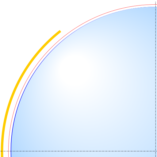
English: Scale drawing of the oblateness of the 2003 IERS reference ellipsoid. The outer edge of the dark blue line is an ellipse with the same eccentricity as that of the Earth, with North at the top. For comparison, the outer edge of the light blue area is a circle of diameter equal to the minor axis (a point on the equator, to its antipode). The red line denotes the Karman line (100 km altitude) and the yellow area, the range of the International Space Station (330-435 km altitude, 51.65-degree orbital inclination). |
| Data | |
| Origem | Obra do próprio |
| Autor | Cmglee |
Licenciamento
Eu, titular dos direitos de autor desta obra, publico-a com as seguintes licenças:
A utilização deste ficheiro é regulada nos termos da licença Creative Commons - Atribuição-CompartilhaIgual 3.0 Não Adaptada.
- Pode:
- partilhar – copiar, distribuir e transmitir a obra
- recombinar – criar obras derivadas
- De acordo com as seguintes condições:
- atribuição – Tem de fazer a devida atribuição da autoria, fornecer uma hiperligação para a licença e indicar se foram feitas alterações. Pode fazê-lo de qualquer forma razoável, mas não de forma a sugerir que o licenciador o apoia ou subscreve o seu uso da obra.
- partilha nos termos da mesma licença – Se remisturar, transformar ou ampliar o conteúdo, tem de distribuir as suas contribuições com a mesma licença ou uma licença compatível com a original.

|
É concedida permissão para copiar, distribuir e/ou modificar este documento nos termos da Licença de Documentação Livre GNU, versão 1.2 ou qualquer versão posterior publicada pela Free Software Foundation; sem Secções Invariantes, sem textos de Capa e sem textos de Contra-Capa. É incluída uma cópia da licença na secção intitulada GNU Free Documentation License. |
Pode escolher a licença que quiser.
Histórico do ficheiro
Clique uma data e hora para ver o ficheiro tal como ele se encontrava nessa altura.
| Data e hora | Miniatura | Dimensões | Utilizador | Comentário | |
|---|---|---|---|---|---|
| atual | 23h52min de 29 de março de 2015 | | 512 × 512 (2 kB) | Cmglee | Show more of ISS domain. |
| 23h42min de 29 de março de 2015 |  | 512 × 512 (2 kB) | Cmglee | {{Information |Description ={{en|1=Scale drawing of the oblateness of a reference geoid. The outer edge of the dark blue line is an ellipse with the same eccentricity as that of the Earth, with north at the top, For comparison, the outer edge of lig... |
Utilização local do ficheiro
A seguinte página usa este ficheiro:
Utilização global do ficheiro
As seguintes wikis usam este ficheiro:
- ar.wikipedia.org
- az.wikipedia.org
- bg.wikipedia.org
- bn.wikipedia.org
- da.wikipedia.org
- en.wikipedia.org
- es.wikipedia.org
- sk.wikipedia.org
- sv.wikipedia.org
- tr.wikipedia.org