
Ficheiro:German Empire states map.svg

Dimensões desta antevisão em PNG do ficheiro SVG: 496 × 600 píxeis Outras resoluções: 198 × 240 píxeis | 397 × 480 píxeis | 635 × 768 píxeis | 847 × 1 024 píxeis | 1 694 × 2 048 píxeis | 1 042 × 1 260 píxeis.
Imagem numa resolução maior (ficheiro SVG, de 1 042 × 1 260 píxeis, tamanho: 2,31 MB)
|
|
Esta imagem provém do Wikimedia Commons, um acervo de conteúdo livre da Wikimedia Foundation que pode ser utilizado por outros projetos.
|
Descrição do ficheiro
| Descrição |
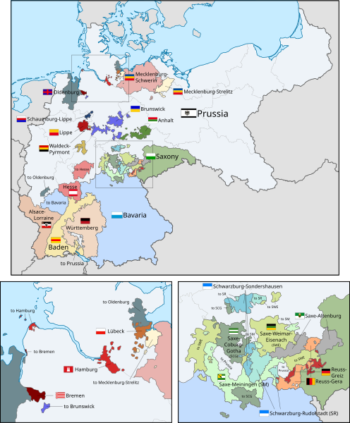
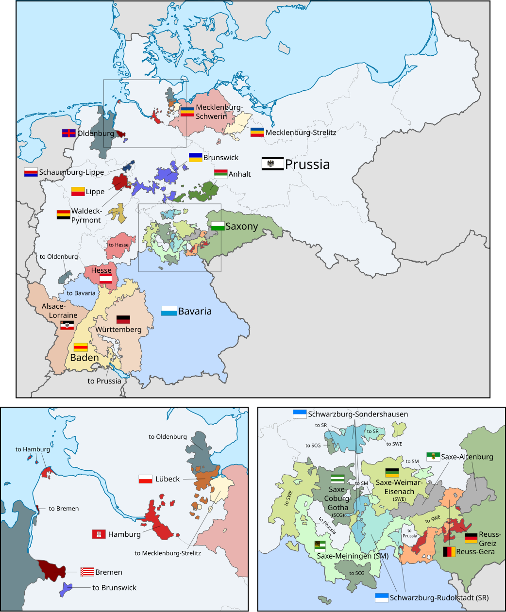
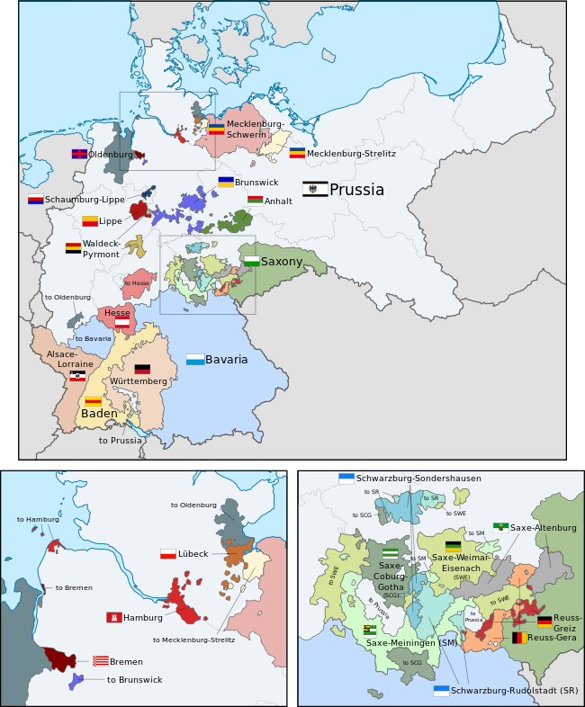
English: A map of the states of the German Empire, showing their location, flags and names in English. |
| Data | |
| Origem |
Este ficheiro foi derivado de: German Empire blank map.svg: Este desenho vetorial inclui elementos que foram usados ou adaptados de: Este desenho vetorial inclui elementos que foram usados ou adaptados de: Este desenho vetorial inclui elementos que foram usados ou adaptados de: Este desenho vetorial inclui elementos que foram usados ou adaptados de: Este desenho vetorial inclui elementos que foram usados ou adaptados de: Este desenho vetorial inclui elementos que foram usados ou adaptados de: Este desenho vetorial inclui elementos que foram usados ou adaptados de: Este desenho vetorial inclui elementos que foram usados ou adaptados de: Este desenho vetorial inclui elementos que foram usados ou adaptados de: Este desenho vetorial inclui elementos que foram usados ou adaptados de: Este desenho vetorial inclui elementos que foram usados ou adaptados de: Este desenho vetorial inclui elementos que foram usados ou adaptados de: Este desenho vetorial inclui elementos que foram usados ou adaptados de: Este desenho vetorial inclui elementos que foram usados ou adaptados de: Este desenho vetorial inclui elementos que foram usados ou adaptados de: Este desenho vetorial inclui elementos que foram usados ou adaptados de: Este desenho vetorial inclui elementos que foram usados ou adaptados de: Este desenho vetorial inclui elementos que foram usados ou adaptados de: Este desenho vetorial inclui elementos que foram usados ou adaptados de: Este desenho vetorial inclui elementos que foram usados ou adaptados de: Este desenho vetorial inclui elementos que foram usados ou adaptados de: Este desenho vetorial inclui elementos que foram usados ou adaptados de: Este desenho vetorial inclui elementos que foram usados ou adaptados de: |
| Autor |
|
| Outras versões |
|
| SVG desenvolvimento | O código-fonte desta imagem SVG é válido. Esta bandeira foi criada com o Other tools Esta bandeira SVG utiliza texto incorporado que pode ser facilmente traduzido usando um editor de texto. |


.svg)
.svg)
.svg)
.svg)
.svg)
.svg)
Licenciamento
Eu, titular dos direitos de autor desta obra, publico-a com a seguinte licença:
A utilização deste ficheiro é regulada nos termos da licença Creative Commons - Atribuição-CompartilhaIgual 3.0 Não Adaptada.
- Pode:
- partilhar – copiar, distribuir e transmitir a obra
- recombinar – criar obras derivadas
- De acordo com as seguintes condições:
- atribuição – Tem de fazer a devida atribuição da autoria, fornecer uma hiperligação para a licença e indicar se foram feitas alterações. Pode fazê-lo de qualquer forma razoável, mas não de forma a sugerir que o licenciador o apoia ou subscreve o seu uso da obra.
- partilha nos termos da mesma licença – Se remisturar, transformar ou ampliar o conteúdo, tem de distribuir as suas contribuições com a mesma licença ou uma licença compatível com a original.
Code for clickable map
Histórico do ficheiro
Clique uma data e hora para ver o ficheiro tal como ele se encontrava nessa altura.
| Data e hora | Miniatura | Dimensões | Utilizador | Comentário | |
|---|---|---|---|---|---|
| atual | 02h43min de 24 de fevereiro de 2019 | | 1 042 × 1 260 (2,31 MB) | Alphathon | Corrected Brunswick territory accidentally given to Anhalt |
| 14h55min de 4 de novembro de 2015 |  | 1 042 × 1 260 (2,39 MB) | Alphathon | Slight optimisation | |
| 01h33min de 4 de novembro de 2015 |  | 1 042 × 1 260 (2,39 MB) | Alphathon | Another minor tweak | |
| 01h31min de 4 de novembro de 2015 |  | 1 042 × 1 260 (2,39 MB) | Alphathon | Tweaked colours | |
| 22h25min de 3 de novembro de 2015 |  | 1 042 × 1 260 (2,39 MB) | Alphathon | Corrected typo | |
| 11h51min de 3 de novembro de 2015 |  | 1 042 × 1 260 (2,39 MB) | Alphathon | {{Information |Description={{en|A map of the states of the en:German Empire, showing their location, flags and names in English.}} |Source={{Derived from|File:German Empire blank map.svg|display=50}} {{AttribSVG|Flagge Herzogtum Anhalt.svg|David... |
Utilização local do ficheiro
As seguintes 3 páginas usam este ficheiro:
Utilização global do ficheiro
As seguintes wikis usam este ficheiro:
- ar.wikipedia.org
- ast.wikipedia.org
- az.wikipedia.org
- ca.wikipedia.org
- en.wikipedia.org
- es.wikipedia.org
- fi.wikipedia.org
- he.wikipedia.org
- hu.wikipedia.org
- it.wikipedia.org
- nl.wikipedia.org
- sr.wikipedia.org
- th.wikipedia.org
- zh.wikipedia.org