
Ficheiro:Holy Roman Empire 1000CE.svg

Dimensões desta antevisão em PNG do ficheiro SVG: 485 × 340 píxeis Outras resoluções: 320 × 224 píxeis | 640 × 449 píxeis | 1 024 × 718 píxeis | 1 280 × 897 píxeis | 2 560 × 1 795 píxeis.
Imagem numa resolução maior (ficheiro SVG, de 485 × 340 píxeis, tamanho: 1,25 MB)
|
|
Esta imagem provém do Wikimedia Commons, um acervo de conteúdo livre da Wikimedia Foundation que pode ser utilizado por outros projetos.
|
Descrição do ficheiro
Este(a) desenho vetorial não especificado foi criado com o Inkscape .


.svg)
.svg)
.svg)
.svg)
.svg)


.svg)
.svg)
.svg)


.png)
.png)


.svg)


.svg)

.svg)


.svg)
.svg)
.svg)
.svg)


.svg)
.png)


.svg)


.svg)
.svg)


.svg)


.svg)


.svg)
.svg)
.svg)
.svg)
.svg)
.svg)
.svg)
.svg)
_cropped.svg)
.svg)
.svg)
.svg)
.svg)
.svg)
.svg)
.svg)
.svg)
.svg)
.svg)
.svg)
.svg)
.svg)
.svg)
.svg)
.svg)
.svg)
.svg)
.svg)
.svg)
.svg)
.svg)
.svg)
.svg)
.svg)
.svg)
.svg)
.svg)
.svg)
.svg)
.svg)
.svg)
.svg)
.svg)
.svg)
.svg)
.svg)
.svg)
.svg)
.svg)
.svg)
.svg)
.svg)
.svg)
.svg)
Licenciamento
A utilização deste ficheiro é regulada nos termos da licença Creative Commons Atribuição-CompartilhaIgual 4.0 Internacional.
- Pode:
- partilhar – copiar, distribuir e transmitir a obra
- recombinar – criar obras derivadas
- De acordo com as seguintes condições:
- atribuição – Tem de fazer a devida atribuição da autoria, fornecer uma hiperligação para a licença e indicar se foram feitas alterações. Pode fazê-lo de qualquer forma razoável, mas não de forma a sugerir que o licenciador o apoia ou subscreve o seu uso da obra.
- partilha nos termos da mesma licença – Se remisturar, transformar ou ampliar o conteúdo, tem de distribuir as suas contribuições com a mesma licença ou uma licença compatível com a original.
Histórico do ficheiro
Clique uma data e hora para ver o ficheiro tal como ele se encontrava nessa altura.
| Data e hora | Miniatura | Dimensões | Utilizador | Comentário | |
|---|---|---|---|---|---|
| atual | 11h09min de 4 de maio de 2021 | | 485 × 340 (1,25 MB) | E-960 | Correction: tribute was paid under Mieszko I, by the year 1000 Bolesław I the Brave stopped paying it |
| 20h28min de 22 de maio de 2016 |  | 485 × 340 (1,25 MB) | Alphathon | Corrected status of Bohemia | |
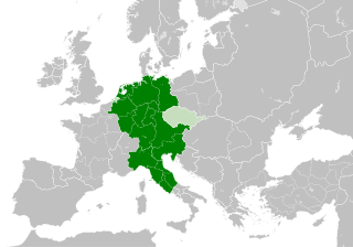
| 18h34min de 22 de maio de 2016 |  | 485 × 340 (1,23 MB) | Alphathon | == {{int:filedesc}} == {{Inkscape}} {{Information |Description={{en|A map of the en:Holy Roman Empire within Europe circa 1000 CE. The main subdivisions of the Byzantine Empire, Holy Roman Empire, Burgundy, France and Poland are also shown. The p... |
Utilização local do ficheiro
A seguinte página usa este ficheiro:
Utilização global do ficheiro
As seguintes wikis usam este ficheiro:
- en.wikipedia.org
.svg)