
Ficheiro:Indian stream map.png
Dimensões desta antevisão: 800 × 575 píxeis. Outras resoluções: 320 × 230 píxeis | 640 × 460 píxeis | 1 024 × 736 píxeis | 1 280 × 920 píxeis | 1 617 × 1 162 píxeis.
Imagem numa resolução maior (1 617 × 1 162 píxeis, tamanho: 147 kB, tipo MIME: image/png)
|
|
Esta imagem provém do Wikimedia Commons, um acervo de conteúdo livre da Wikimedia Foundation que pode ser utilizado por outros projetos.
|
Descrição do ficheiro
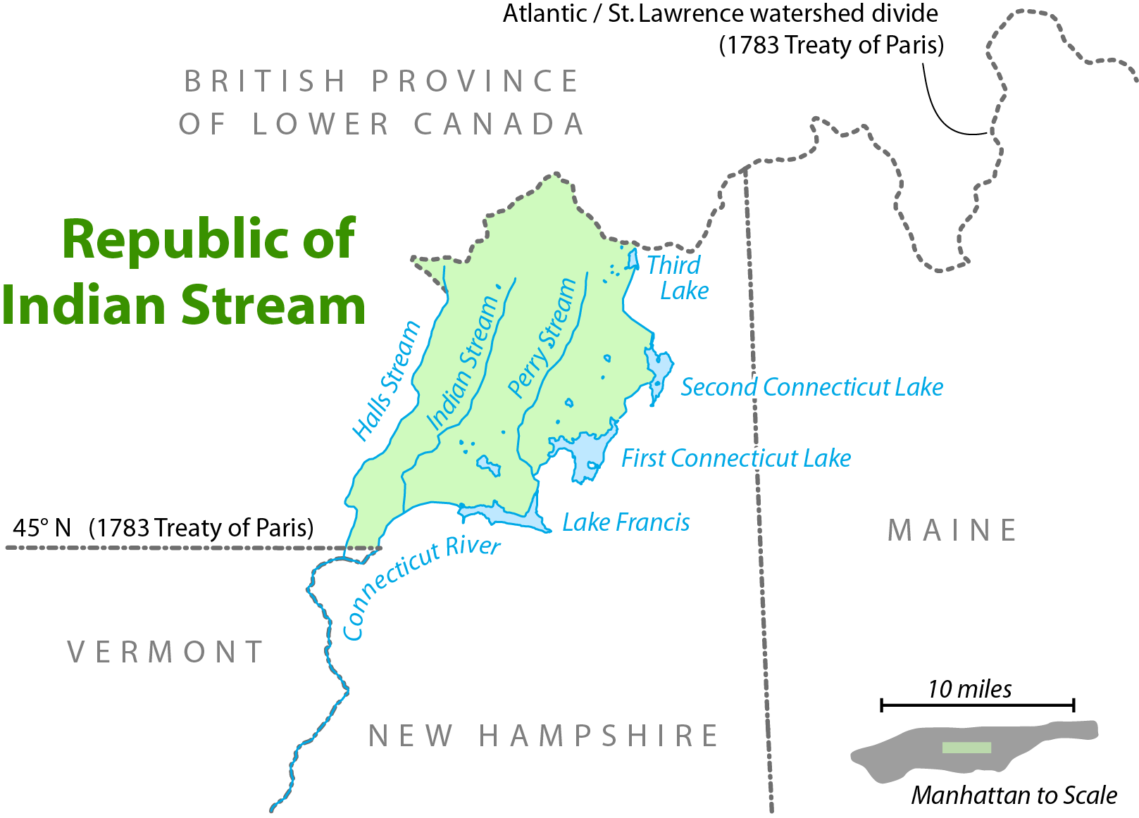
| Descrição | Map showing the location of the Republic of Indian Stream. I, Citynoise, am the creator of this map and hereby release it under the ShareAlike Attribution License. See www.radicalcartography.net for more. |
| Data | 18 de junho de 2006 (data de carregamento original) |
| Origem | Transferido de en.wikipedia para a wiki Commons. |
| Autor |
Este ficheiro foi inicialmente carregado por Citynoise em Wikipédia em inglês Later versions were uploaded by AnonMoos at en.wikipedia. |

|
Esta imagem de mapas (ou todas as imagens neste artigo ou categoria) deveriam ser recriadas usando gráficos vectoriais, como ficheiros SVG. Isto tem várias vantagens; veja as Commons:Media for cleanup|imagens para rever para mais informações. Se já criou um ficheiro SVG desta imagem, por favor, carregue-o. Depois do novo ficheiro SVG ter sido carregado, substitua aqui esta predefinição pela predefinição {{vector version available|nome da nova imagem.svg}}.
|
Licenciamento
A utilização deste ficheiro é regulada nos termos da licença Creative Commons - Atribuição-CompartilhaIgual 2.5 Genérica.
- Pode:
- partilhar – copiar, distribuir e transmitir a obra
- recombinar – criar obras derivadas
- De acordo com as seguintes condições:
- atribuição – Tem de fazer a devida atribuição da autoria, fornecer uma hiperligação para a licença e indicar se foram feitas alterações. Pode fazê-lo de qualquer forma razoável, mas não de forma a sugerir que o licenciador o apoia ou subscreve o seu uso da obra.
- partilha nos termos da mesma licença – Se remisturar, transformar ou ampliar o conteúdo, tem de distribuir as suas contribuições com a mesma licença ou uma licença compatível com a original.
Registo de carregamento original
A página de descrição original está aqui. Todos os nomes de utilizador a seguir referem-se a en.wikipedia.
- 2006-09-28 11:01 AnonMoos 754×548×8 (92671 bytes) trimming excessive margins (whitespace), increasing PNG compression...
- 2006-06-27 00:48 Citynoise 800×600×8 (115636 bytes) fixed error in date of Treaty of Paris.
- 2006-06-18 03:09 Citynoise 800×600×8 (119474 bytes) Map showing the location of the Republic of Indian Stream. I, Citynoise, am the creator of this map and hereby release it under the ShareAlike Attribution License. See www.radicalcartography.net for more. Added scale.
- 2006-06-18 02:43 Citynoise 800×588×8 (118009 bytes) Map showing the location of the Republic of Indian Stream. I, Citynoise, am the creator of this map and hereby release it under the ShareAlike Attribution License. See www.radicalcartography.net for more.
Histórico do ficheiro
Clique uma data e hora para ver o ficheiro tal como ele se encontrava nessa altura.
| Data e hora | Miniatura | Dimensões | Utilizador | Comentário | |
|---|---|---|---|---|---|
| atual | 17h56min de 6 de setembro de 2016 | | 1 617 × 1 162 (147 kB) | Citynoise | Corrected name of Lower Canada |
| 17h03min de 10 de abril de 2007 |  | 754 × 548 (90 kB) | Liftarn | {{Information |Description=Map showing the location of the Republic of Indian Stream. I, Citynoise, am the creator of this map and hereby release it under the ShareAlike Attribution License. See www.radicalcartography.net for more. |Source=Originally fr |
Utilização local do ficheiro
A seguinte página usa este ficheiro:
Utilização global do ficheiro
As seguintes wikis usam este ficheiro:
- ar.wikipedia.org
- bn.wikipedia.org
- de.wikipedia.org
- en.wikipedia.org
- en.wiktionary.org
- es.wikipedia.org
- et.wikipedia.org
- fr.wikipedia.org
- ja.wikipedia.org
- nl.wikipedia.org
- ru.wikipedia.org
- www.wikidata.org