
Ficheiro:Mapa dos caminhos de ferro em Portugal 1895 - Rede do Minho.jpg
Imagem numa resolução maior (512 × 700 píxeis, tamanho: 373 kB, tipo MIME: image/jpeg)
|
|
Esta imagem provém do Wikimedia Commons, um acervo de conteúdo livre da Wikimedia Foundation que pode ser utilizado por outros projetos.
|
Descrição do ficheiro
| Descrição |
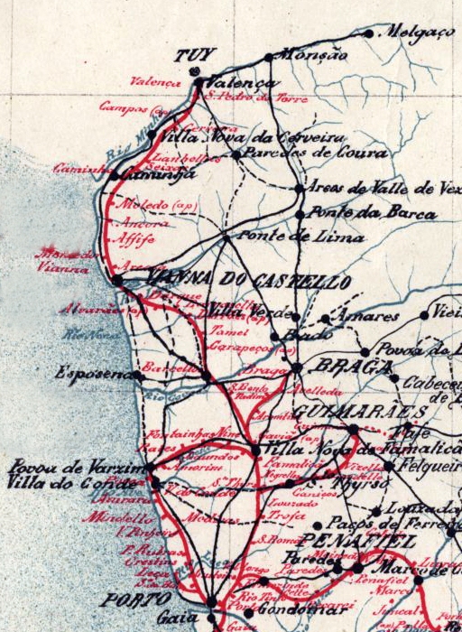
English: Map of the railway network at the Minho and Douro Litoral regions, in northen Portugal, in 1895. The main axis was the Linha do Minho (Minho Railway), in iberian gauge, connecting the city of Porto to the border town of Valença, with a spur to Braga. There was also a network of narrow gauge lines, connecting the city of Porto to Póvoa de Varzim, Guimarães and Famalicão. Português: Mapa da rede ferroviária nas antigas regiões portuguesas do Minho e Douro Litoral, em 1895. A espinha dorsal deste sistema era a Linha do Minho, de bitola ibérica, que ligava o Porto a Valença, com um ramal para Braga. Existia também uma rede ferroviária secundária, de bitola métrica, unindo o Porto a Guimarães, Póvoa de Varzim e Famalicão. |
| Data | (UTC) |
| Origem |
Este ficheiro foi derivado de: Mapa dos caminhos de ferro em Portugal 1895.jpg:  |
| Autor |
|
| Esta é uma imagem retocada, o que significa que a versão original foi alterada digitalmente. Modificações: Isolated the Minho and Douro Litoral regions. O original pode ser visto aqui: Mapa dos caminhos de ferro em Portugal 1895.jpg:
|
Licenciamento
|
Esta obra está no domínio público no seu país de origem e noutros países e áreas onde o período de proteção dos direitos de autor é igual ou inferior à vida do autor mais 70 anos. Esta obra está no domínio público nos Estados Unidos porque foi publicada (ou registada no U.S. Copyright Office) antes de 1 de janeiro de 1929. | |
| Este ficheiro foi considerado livre de restrições conhecidas devidas a direitos de autor, incluindo todos os direitos conexos. | |
Registo de carregamento original
This image is a derivative work of the following images:
- File:Mapa dos caminhos de ferro em Portugal 1895.jpg licensed with PD-old-70-expired
- 2015-08-30T17:29:23Z Polyethylen 2382x3892 (8926900 Bytes) User created page with UploadWizard
Carregada com derivativeFX
Histórico do ficheiro
Clique uma data e hora para ver o ficheiro tal como ele se encontrava nessa altura.
| Data e hora | Miniatura | Dimensões | Utilizador | Comentário | |
|---|---|---|---|---|---|
| atual | 13h33min de 12 de setembro de 2020 | | 512 × 700 (373 kB) | Ajpvalente | == {{int:filedesc}} == {{Information |Description={{en|1=Map of the railway network at the Minho and Douro Litoral regions, in northen Portugal, in 1895. The main axis was the Linha do Minho (Minho Railway), in iberian gauge, connecting the city of Porto to the border town of Valença, with a spur to Braga. There was also a network of narrow gauge lines, connecting the city of Porto to Póvoa de Varzim, Guimarães and Famalicão.}}{{pt|1=Mapa da rede ferroviária nas antigas regiões portuguesas do... |
Utilização local do ficheiro
As seguintes 8 páginas usam este ficheiro: