
Ficheiro:Red dawn 1984 movie start of ww3.PNG

Imagem numa resolução maior (1 400 × 628 píxeis, tamanho: 49 kB, tipo MIME: image/png)
|
|
Esta imagem provém do Wikimedia Commons, um acervo de conteúdo livre da Wikimedia Foundation que pode ser utilizado por outros projetos.
|

|
Este mapa, assim como outros mapas fictícios, é fictício ou muito incorreto (ou seja, devido ao anacronismo) para ser usado em contextos da vida real (contemporânea ou histórica). Pode ter alguns elementos visuais semelhantes aos mapas oficiais, como cores ou certos recursos de layout, mas NÃO são oficiais e não têm nenhum reconhecimento oficial. |
Descrição do ficheiro
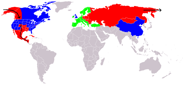
Map of fictional events in the 1984 movie Red Dawn, at the start of World War III.
- Blue = US and allies (United Kingdom "England", China "600 million screaming Chinamen", presumably Unoccupied Canada)
- Green = Neutral (Europe, "they're sitting this one out")
- Red = USSR and allies (showing USSR invasion of Alaska "stopped butt cold" at the contiguous 48 US border, Occupied Canadian Provinces of British Columbia, Western portion of Alberta and the Yukon Territory, Honduras, El Salvador, and Guatemala fall, Mexico in revolution, Texas described as being behind enemy lines, Oklahoma and most of Kansas, Louisiana, Arkansas, and Missouri probably overrun too, Colorado where the movie is set - invasion force stopped at Cheyenne, Wyoming. Blue circle shows Denver under siege.)
- Grey = Unknown
- Red squares = use of Soviet nuclear weapons - Beijing "there were", Washington, Kansas City & Omaha
At the end of the movie the US is implied on a plaque as having won the war, although how they did it is not explained.
If The US stopped them at the Mississippi River, then the color used for the US state Mississippi is incorrect. Mississippi would be part of F.A. (Free America) not occupied as the map indicates.
Licenciamento

|
É concedida permissão para copiar, distribuir e/ou modificar este documento nos termos da Licença de Documentação Livre GNU, versão 1.2 ou qualquer versão posterior publicada pela Free Software Foundation; sem Secções Invariantes, sem textos de Capa e sem textos de Contra-Capa. É incluída uma cópia da licença na secção intitulada GNU Free Documentation License. |
| A utilização deste ficheiro é regulada nos termos da licença Creative Commons - Atribuição-CompartilhaIgual 3.0 Não Adaptada. | ||
| ||
| Esta marca de licenciamento foi adicionada a este ficheiro durante a atualização da licença GFDL. |

|
Esta imagem de fictional map (ou todas as imagens neste artigo ou categoria) deveriam ser recriadas usando gráficos vectoriais, como ficheiros SVG. Isto tem várias vantagens; veja as Commons:Media for cleanup|imagens para rever para mais informações. Se já criou um ficheiro SVG desta imagem, por favor, carregue-o. Depois do novo ficheiro SVG ter sido carregado, substitua aqui esta predefinição pela predefinição {{vector version available|nome da nova imagem.svg}}.
|
Histórico do ficheiro
Clique uma data e hora para ver o ficheiro tal como ele se encontrava nessa altura.
| Data e hora | Miniatura | Dimensões | Utilizador | Comentário | |
|---|---|---|---|---|---|
| atual | 20h09min de 23 de dezembro de 2008 | | 1 400 × 628 (49 kB) | Shibo77 | {{Information |Description=.. |Source=Roke |Date=.. |Author=Roke |Permission=.. |other_versions=.. }} <!--{{ImageUpload|basic}}--> |
| 12h36min de 18 de junho de 2008 |  | 1 400 × 628 (49 kB) | Peephole | {{Information |Description= |Source= |Date= |Author= |Permission= |other_versions= }} | |
| 01h14min de 5 de outubro de 2007 |  | 1 400 × 628 (49 kB) | Hoshie | added Cabinda (between Angola and Zaire), fixed YAR/PDRY boundary. | |
| 19h17min de 10 de setembro de 2007 |  | 1 400 × 628 (49 kB) | Bart133 | == Summary == Map of fictional events in 1984 movie Red Dawn, at the start of World War III *Blue = US and allies (United Kingdom, China "600 million screaming Chinamen", presumably Unoccupied Canada) *Green = Neutral (Europe, "they're sitting this one o | |
| 00h54min de 13 de abril de 2006 |  | 1 400 × 628 (49 kB) | Roke~commonswiki | Map of fictional events in 1984 movie Red Dawn, at the start of World War III Blue = US and allies (England, China "600 million screaming Chinamen", presumably Canada) Green = Neutral (Europe, "theyre sitting this one out") Red = USSR and allies (showing |
Utilização local do ficheiro
A seguinte página usa este ficheiro:
Utilização global do ficheiro
As seguintes wikis usam este ficheiro:
- ar.wikipedia.org
- ca.wikipedia.org
- cy.wikipedia.org
- de.wikipedia.org
- en.wikipedia.org
- eo.wikipedia.org
- es.wikipedia.org
- eu.wikipedia.org
- fi.wikipedia.org
- fr.wikipedia.org
- id.wikipedia.org
- it.wikipedia.org
- ja.wikipedia.org
- ko.wikipedia.org
- ms.wikipedia.org
- nds.wikipedia.org
- nl.wikipedia.org
- no.wikipedia.org
- pl.wikipedia.org
- ru.wikipedia.org
- simple.wikipedia.org
- sv.wikipedia.org
- uk.wikipedia.org
- zh.wikipedia.org