
Ficheiro:Ww2 europe map italy june until december 1944.jpg

Dimensões desta antevisão: 785 × 599 píxeis. Outras resoluções: 314 × 240 píxeis | 629 × 480 píxeis | 1 006 × 768 píxeis | 1 265 × 966 píxeis.
Imagem numa resolução maior (1 265 × 966 píxeis, tamanho: 1,89 MB, tipo MIME: image/jpeg)
|
|
Esta imagem provém do Wikimedia Commons, um acervo de conteúdo livre da Wikimedia Foundation que pode ser utilizado por outros projetos.
|
Descrição do ficheiro
| Descrição |
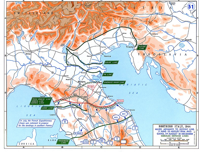
English: Allied Corp formations are depicted in blue. The German defensive lines are shown in green. The solid red line denotes the extent of the Allied advance by 29 August 1944, and the dotted red line is the extent of the Allied advance by 31 December 1944. |
| Data | |
| Origem | Archive link to original website used for the map and the archive link to the map source page. |
| Autor | The History Department of the United States Military Academy |
| Permissão (Reutilizar este ficheiro) |
US Government document |
| Outras versões |
The current version of the map by the The History Department of the United States Military Academy: |

Licenciamento
Esta imagem é um trabalho de um soldado ou funcionário do Exército dos Estados Unidos, tirada ou feita durante o curso de uma tarefa oficial. Como trabalho do Governo Federal dos Estados Unidos, a imagem está em domínio público.
|
 |
Histórico do ficheiro
Clique uma data e hora para ver o ficheiro tal como ele se encontrava nessa altura.
| Data e hora | Miniatura | Dimensões | Utilizador | Comentário | |
|---|---|---|---|---|---|
| atual | 03h25min de 20 de fevereiro de 2021 | | 1 265 × 966 (1,89 MB) | Buidhe | Reverted to version as of 14:07, 29 February 2020 (UTC) Not a minor change, should be uploaded as new file |
| 02h57min de 20 de fevereiro de 2021 |  | 973 × 754 (349 kB) | EnigmaMcmxc | updated version of the map | |
| 14h07min de 29 de fevereiro de 2020 |  | 1 265 × 966 (1,89 MB) | Hohum | Fix colour profile | |
| 18h21min de 22 de junho de 2011 |  | 1 265 × 966 (1,93 MB) | Hohum | Cleanup | |
| 12h26min de 10 de dezembro de 2006 |  | 1 265 × 966 (2,01 MB) | MatthiasKabel | == License information == {{PD-Layout}} {{PD-USGov}} Original from http://www.dean.usma.edu/history/web03/atlases/ww2%20europe/ww2%20europe%20war%20index.htm |
Utilização local do ficheiro
A seguinte página usa este ficheiro:
Utilização global do ficheiro
As seguintes wikis usam este ficheiro:
- af.wikipedia.org
- ar.wikipedia.org
- cs.wikipedia.org
- de.wikipedia.org
- en.wikipedia.org
- es.wikipedia.org
- fi.wikipedia.org
- fr.wikipedia.org
- he.wikipedia.org
- hu.wikipedia.org
- id.wikipedia.org
- it.wikipedia.org
- ja.wikipedia.org
- nl.wikipedia.org
- no.wikipedia.org
- pl.wikipedia.org
- ru.wikipedia.org
- sk.wikipedia.org
- sl.wikipedia.org
- sr.wikipedia.org
- sv.wikipedia.org
- ta.wikipedia.org
- uk.wikipedia.org
- www.wikidata.org
- zh.wikipedia.org