
Ficheiro:Europe Köppen Map.png
Dimensões desta antevisão: 800 × 509 píxeis. Outras resoluções: 320 × 204 píxeis | 640 × 407 píxeis | 1 024 × 652 píxeis | 1 280 × 815 píxeis | 1 885 × 1 200 píxeis.
Imagem numa resolução maior (1 885 × 1 200 píxeis, tamanho: 831 kB, tipo MIME: image/png)
|
|
Esta imagem provém do Wikimedia Commons, um acervo de conteúdo livre da Wikimedia Foundation que pode ser utilizado por outros projetos.
|
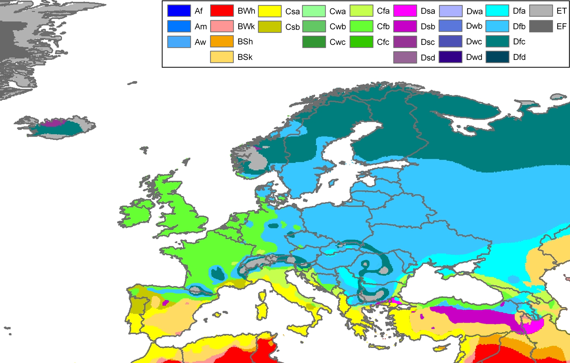
| Peel, M. C. and Finlayson, B. L. and McMahon, T. A. (2007). "Updated world map of the Köppen-Geiger climate classification". Hydrol. Earth Syst. Sci. 11: 1633-1644. ISSN 1027-5606. |
Legend
Descrição do ficheiro
| Descrição | Climate map of Europe (from the "Updated world map of the Köppen-Geiger climate classification"). |
| Data | |
| Origem | Hydrology and Earth System Sciences: "Updated world map of the Köppen-Geiger climate classification" (Supplement) - Original file was a JPG-file, this file is has been converted to a PNG-file, without extra modifications, by me (Jeroen). |
| Autor |
Peel, M. C., Finlayson, B. L., and McMahon, T. A. (University of Melbourne) |
| Permissão (Reutilizar este ficheiro) |
|
| Outras versões | Obras derivadas deste ficheiro: Köppen Map Europe 01.png |
Related maps
User Jeroenvrp made for these continents and areas a cropped and resized version:
- Africa Köppen Map.png
- Asia Köppen Map.png
- Australia-Oceania Köppen Map.png
- Europe Köppen Map.png
- North America Köppen Map.png
- Russia Köppen Map.png
- South America Köppen Map.png
- West Asia Köppen Map.png.
User LordToran made from the same data these maps:
- Klimagürtel-der-erde-eisklima.png
- Klimagürtel-der-erde-gemäßigte-zone.png
- Klimagürtel-der-erde-polargebiete.png
- Klimagürtel-der-erde-subtropen.png
- Klimagürtel-der-erde-tropen.png
- Klimagürtel-der-erde-tundra.png
- Klimagürtel-der-erde-warmgemäßigte-zone.png
- Klimagürtel-der-erde.png
- Klimagürtel-der-erde.svg
- Klimate-humidität.png
- Köppen-geiger-hessd-2007.svg
- Köppen-vereinfacht.svg
- Trockenklimate.png
Licenciamento
A utilização deste ficheiro é regulada nos termos da licença Creative Commons - Atribuição-CompartilhaIgual 3.0 Não Adaptada.
- Pode:
- partilhar – copiar, distribuir e transmitir a obra
- recombinar – criar obras derivadas
- De acordo com as seguintes condições:
- atribuição – Tem de fazer a devida atribuição da autoria, fornecer uma hiperligação para a licença e indicar se foram feitas alterações. Pode fazê-lo de qualquer forma razoável, mas não de forma a sugerir que o licenciador o apoia ou subscreve o seu uso da obra.
- partilha nos termos da mesma licença – Se remisturar, transformar ou ampliar o conteúdo, tem de distribuir as suas contribuições com a mesma licença ou uma licença compatível com a original.
Histórico do ficheiro
Clique uma data e hora para ver o ficheiro tal como ele se encontrava nessa altura.
| Data e hora | Miniatura | Dimensões | Utilizador | Comentário | |
|---|---|---|---|---|---|
| atual | 22h30min de 22 de novembro de 2017 | | 1 885 × 1 200 (831 kB) | Mélomène | Cantabrian Asturian, Pyrenean, Alps, Carpathian Mts formed ranges. |
| 12h18min de 13 de março de 2011 |  | 1 885 × 1 200 (957 kB) | Maphobbyist | Painted the Caspian Sea as white as it should have been, because the Köppen system is based on the concept that climate types are correlated with the natural vegetation. Thus with Köppen, climate zone boundaries have been selected with vegetation distri | |
| 22h59min de 12 de outubro de 2007 |  | 1 885 × 1 200 (868 kB) | Jeroen | Citation: '''Peel, M. C., Finlayson, B. L., and McMahon, T. A.: Updated world map of the Köppen-Geiger climate classification, Hydrol. Earth Syst. Sci., 11, 1633-1644, 2007.''' {{Information |Description= Climate map of Europe (from the "[[:Image:Worl |
Utilização local do ficheiro
As seguintes 2 páginas usam este ficheiro:
Utilização global do ficheiro
As seguintes wikis usam este ficheiro:
- cs.wikipedia.org
- da.wikipedia.org
- de.wikipedia.org
- en.wikipedia.org
- eo.wikipedia.org
- es.wikipedia.org
- es.wikibooks.org
- fr.wikipedia.org
- fy.wikipedia.org
- hi.wikipedia.org
- hu.wikipedia.org
- ja.wikipedia.org
- ka.wikipedia.org
- kk.wikipedia.org
- mk.wikipedia.org
- nl.wikipedia.org
- ru.wikipedia.org
- sl.wikipedia.org
- sr.wikipedia.org
- th.wikipedia.org
- tr.wikipedia.org