
Ficheiro:Geological map of the southeast San Juan Basin.png

Dimensões desta antevisão: 800 × 397 píxeis. Outras resoluções: 320 × 159 píxeis | 640 × 317 píxeis | 1 024 × 508 píxeis | 1 280 × 634 píxeis | 3 250 × 1 611 píxeis.
Imagem numa resolução maior (3 250 × 1 611 píxeis, tamanho: 1,09 MB, tipo MIME: image/png)
|
|
Esta imagem provém do Wikimedia Commons, um acervo de conteúdo livre da Wikimedia Foundation que pode ser utilizado por outros projetos.
|
Descrição do ficheiro
| Descrição |
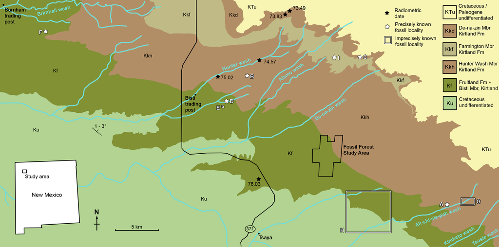
Geological map of the southeast San Juan Basin showing localities of radiometric dates and important fossil specimens mentioned in the text. Collection localities; (A) SMP VP-1500, Navajoceratops sullivani, holotype; (B) NMMNH P-27486, Terminocavus sealeyi, holotype; (C) NMMNH P-33906, Denazin chasmosaurine; (D) NMMNH P-37880, c.f. Pentaceratops sternbergii, parietal fragment; (E) UKVP 16100, c.f. P. sternbergii, complete skull; (F) MNA Pl.1747, c.f. P. sternbergii, complete skull; (G) USNM 8604, Chasmosaurinae sp. anterior end of a parietal median bar; (H) purported collection area of AMNH 6325, P. sternbergii, holotype. (I) NMMNH P-50000, Chasmosaurinae sp. (now Bisticeratops), skull missing frill. Radiometric dates recalibrated from Fassett & Steiner (1997) by Fowler (2017). Bedrock geology altered from O’Sullivan & Beikman (1963). |
| Data | |
| Origem | https://peerj.com/articles/9251/ |
| Autor | Denver W. Fowler, Elizabeth A. Freedman Fowler |
Licenciamento
A utilização deste ficheiro é regulada nos termos da licença Creative Commons Atribuição 4.0 Internacional.
- Pode:
- partilhar – copiar, distribuir e transmitir a obra
- recombinar – criar obras derivadas
- De acordo com as seguintes condições:
- atribuição – Tem de fazer a devida atribuição da autoria, fornecer uma hiperligação para a licença e indicar se foram feitas alterações. Pode fazê-lo de qualquer forma razoável, mas não de forma a sugerir que o licenciador o apoia ou subscreve o seu uso da obra.
Histórico do ficheiro
Clique uma data e hora para ver o ficheiro tal como ele se encontrava nessa altura.
| Data e hora | Miniatura | Dimensões | Utilizador | Comentário | |
|---|---|---|---|---|---|
| atual | 17h57min de 5 de junho de 2020 | | 3 250 × 1 611 (1,09 MB) | FunkMonk | {{Information |description=Geological map of the southeast San Juan Basin showing localities of radiometric dates and important fossil specimens mentioned in the text. Collection localities; (A) SMP VP-1500, Navajoceratops sullivani, holotype; (B) NMMNH P-27486, Terminocavus sealeyi, holotype; (C) NMMNH P-33906, Denazin chasmosaurine; (D) NMMNH P-37880, c.f. Pentaceratops sternbergii, parietal fragment; (E) UKVP 16100, c.f. P. sternbergii, complete skull; (F) MNA Pl.1747, c.f. P. sternbergii,... |
Utilização local do ficheiro
As seguintes 2 páginas usam este ficheiro:
Utilização global do ficheiro
As seguintes wikis usam este ficheiro:
- en.wikipedia.org
- es.wikipedia.org
- fr.wikipedia.org
- ja.wikipedia.org
- nl.wikipedia.org
- ru.wikipedia.org
- zh.wikipedia.org