
Ficheiro:Map Denmark Demis SE islands.gif
Sem resolução maior disponível.
Map_Denmark_Demis_SE_islands.gif (415 × 420 píxeis, tamanho: 23 kB, tipo MIME: image/gif)
|
|
Esta imagem provém do Wikimedia Commons, um acervo de conteúdo livre da Wikimedia Foundation que pode ser utilizado por outros projetos.
|
Descrição do ficheiro
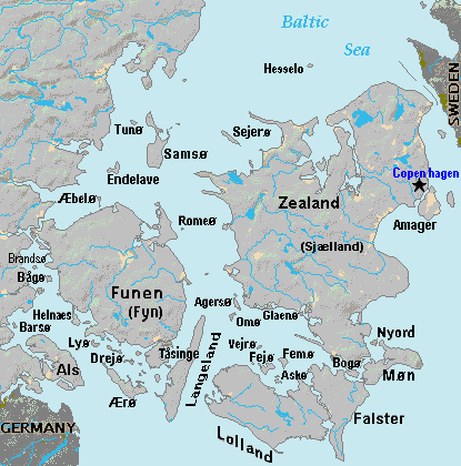
| Descrição | Terrain map of southeast Denmark, showing the major islands labeled, in the region between Germany and Sweden. The terrain data was extracted from the Demis map (on Wikimedia Commons) Image:La2-demis-denmark.png, and the extracted map was color-shifted to grayshade land areas (from the green Demis map). Labels are in font face Arial or Arial Narrow, sizes 8-10. |
| Data | |
| Origem | Derivative of Demis map: Image:La2-demis-denmark.png |
| Autor | Wikid77 (derivative of Demis map) |
Licenciamento
This image is in the public domain because it came from the site https://www.demis.nl/products/web-map-server/examples/ and was released by the copyright holder. Permission is granted to copy, distribute and/or modify this map since it is based on free of copyright images from: www.demis.nl. See also approval email on de.wp and its clarification.
|
| Esta obra foi colocada em domínio público pelo detentor dos direitos autorais, www.demis.nl. Isto se aplica em todo o mundo. Nalguns países isto pode não ser legalmente possível; se assim for: www.demis.nl concede a todos o direito de usar esta obra para qualquer fim, sem quaisquer condições, a menos que tais condições sejam impostas por lei.
|
Histórico do ficheiro
Clique uma data e hora para ver o ficheiro tal como ele se encontrava nessa altura.
| Data e hora | Miniatura | Dimensões | Utilizador | Comentário | |
|---|---|---|---|---|---|
| atual | 18h51min de 3 de setembro de 2007 | | 415 × 420 (23 kB) | Wikid77 | added 14 island names |
| 10h50min de 2 de setembro de 2007 |  | 415 × 420 (22 kB) | Wikid77 | added "Sejero" + "Amager" | |
| 12h56min de 1 de setembro de 2007 |  | 415 × 420 (22 kB) | Wikid77 | cut height 10px for square/undistorted resizing; cut banner "DENMARK" to appear in banner version | |
| 12h46min de 1 de setembro de 2007 |  | 415 × 430 (22 kB) | Wikid77 | cut map width 10px as 415px magnified 3%; banner "DENMARK"; enlarged names; darkened Germany/Sweden | |
| 13h36min de 31 de agosto de 2007 |  | 425 × 430 (22 kB) | Wikid77 | Terrain map of southeast Denmark, showing the major islands labeled, in the region between Germany and Sweden. The terrain data was extracted from the Demis map (on Wikimedia Commons) Image:La2-demis-denmark.png , and the extracted map w |
Utilização local do ficheiro
As seguintes 3 páginas usam este ficheiro:
Utilização global do ficheiro
As seguintes wikis usam este ficheiro:
- da.wikipedia.org
- el.wikipedia.org
- en.wikipedia.org
- es.wikipedia.org
- fi.wikipedia.org
- fr.wikipedia.org
- gl.wikipedia.org
- hr.wikipedia.org
- it.wikipedia.org
- ka.wikipedia.org
- la.wikipedia.org
- lt.wikipedia.org
- sl.wikipedia.org
- vi.wikipedia.org
- zh.wikipedia.org