
Ficheiro:2011 UN Human Development Report Quartiles.svg

Dimensões desta antevisão em PNG do ficheiro SVG: 800 × 353 píxeis Outras resoluções: 320 × 141 píxeis | 640 × 283 píxeis | 1 024 × 452 píxeis | 1 280 × 565 píxeis | 2 560 × 1 130 píxeis | 940 × 415 píxeis.
Imagem numa resolução maior (ficheiro SVG, de 940 × 415 píxeis, tamanho: 1,45 MB)
|
|
Esta imagem provém do Wikimedia Commons, um acervo de conteúdo livre da Wikimedia Foundation que pode ser utilizado por outros projetos.
|
Descrição do ficheiro
| Descrição |
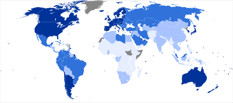
English: The United Nations Human Development Index (HDI) rankings for 2011. For full details, see List of countries by Human Development Index (en.wikipedia)
Español: Evaluación de 2011 para la Organización de las Naciones Unidas del Índice de desarrollo humano (IDH). Para más detalles, ver la lista de países por índice de desarrollo humano (es.wikipedia.org)
Français : L'évaluation de 2011 par l'Organisation des Nations unies de l'indice de développement humain (IDH) des pays du monde. Pour les détails complets, voir la liste des pays par IDH (fr.wikipedia.org).
Suomi: Valtiot w:fi:YK:n inhimillisen kehityksen indeksillä mitattuna vuonna 2011. Tutustu myös luetteloon valtioista inhimillisen kehityksen indeksin mukaan. (en.wikipedia)
Türkçe: Birleşmiş Milletler 2011 İnsani Gelişmişlik Ekdeksi sıralaması. Tüm liste için İnsani Gelişme Endeksi'ne göre ülkeler listesi'ne bakınız (tr.wikipedia.org)
|
||||||||||
| Data | (UTC) | ||||||||||
| Origem | |||||||||||
| Autor |
|
||||||||||
| SVG desenvolvimento | O código-fonte desta imagem SVG é válido. Esta carta geográfica foi criada com o Other tools |
Licenciamento
A utilização deste ficheiro é regulada nos termos da licença Creative Commons - Atribuição-CompartilhaIgual 3.0 Não Adaptada.
- Pode:
- partilhar – copiar, distribuir e transmitir a obra
- recombinar – criar obras derivadas
- De acordo com as seguintes condições:
- atribuição – Tem de fazer a devida atribuição da autoria, fornecer uma hiperligação para a licença e indicar se foram feitas alterações. Pode fazê-lo de qualquer forma razoável, mas não de forma a sugerir que o licenciador o apoia ou subscreve o seu uso da obra.
- partilha nos termos da mesma licença – Se remisturar, transformar ou ampliar o conteúdo, tem de distribuir as suas contribuições com a mesma licença ou uma licença compatível com a original.
Registo de carregamento original
This image is a derivative work of the following images:
- File:BlankMap-World6,_compact.svg licensed with PD-self
- 2011-07-21T10:51:07Z EmilJ 940x415 (1518021 Bytes) fix position of Marshall Islands, per [[File talk:BlankMap-World6.svg#Marshall Islands]]
- 2011-07-09T19:55:11Z Smurfy 940x415 (1517991 Bytes) Reverted to version as of 17:18, 9 July 2011
- 2011-07-09T19:54:56Z Smurfy 940x415 (1517991 Bytes) No changes, just attempting to make thumbnails update
- 2011-07-09T17:18:56Z Smurfy 940x415 (1517991 Bytes) Added South Sudan with code "qx" as per BlankMap-World6.svg
- 2010-05-24T23:02:45Z Saftorangen 940x415 (1515385 Bytes) To match the original map: "Grey move : B9B9B9 to E0E0E0 according to wikipedia convention." See the [[:commons:File_talk:BlankMap-World6.svg#Color_update_need|file talk of BlankMap-World6.svg]].
- 2009-10-12T06:40:51Z Fibonacci 940x415 (1515385 Bytes) Same fixes as for the full map.
- 2008-12-02T18:21:18Z Lokal_Profil 940x415 (1518276 Bytes) Reverted to version as of 14:51, 13 June 2008, new image has non of the complexity (i.e. colouring abilities etc.) of the old
- 2008-12-02T17:29:39Z Harbin 1326x601 (176022 Bytes)
- 2008-12-02T17:26:08Z Harbin 1425x625 (189017 Bytes)
- 2008-06-13T14:51:25Z Lokal_Profil 940x415 (1518276 Bytes) Syncing with [[:Image:BlankMap-World6.svg]] version (01:30, March 29, 2008). Sadly enough the validator does not seem to like rdf element of the metadata although it should work acording to http://www.w3schools.com/rdf/rdf_ma
- 2008-02-08T20:55:35Z CarolSpears 940x415 (1528750 Bytes) validated, maybe
- 2007-12-14T19:51:17Z Lokal_Profil 940x415 (1529675 Bytes) Readded an ocean object but this one is square instead of the original elliptic one
- 2007-12-14T19:19:56Z Lokal_Profil 940x415 (1529845 Bytes) {{Information |Description=Detailed SVG map with grouping enabled to connect all non-contiguous parts of a country's territory for easy colouring. Smaller countries can also be represented by larger circles to show their data
Carregada com derivativeFX
Histórico do ficheiro
Clique uma data e hora para ver o ficheiro tal como ele se encontrava nessa altura.
| Data e hora | Miniatura | Dimensões | Utilizador | Comentário | |
|---|---|---|---|---|---|
| atual | 22h08min de 2 de novembro de 2011 | | 940 × 415 (1,45 MB) | Giro720 | == {{int:filedesc}} == {{Information |Description=The United Nations Human Development Index (HDI) rankings for 2011. For full details, see [[w:en:List of countries by Human Development Index|List o |
Utilização local do ficheiro
A seguinte página usa este ficheiro:
Utilização global do ficheiro
As seguintes wikis usam este ficheiro:
- ar.wikipedia.org
- ast.wikipedia.org
- ba.wikipedia.org
- be.wikipedia.org
- bn.wikipedia.org
- ca.wikipedia.org
- diq.wikipedia.org
- el.wikipedia.org
- en.wikipedia.org
- eo.wikipedia.org
- es.wikipedia.org
- fr.wikipedia.org
- ilo.wikipedia.org
- ka.wikipedia.org
- mk.wikipedia.org
- no.wikipedia.org
- pnb.wikipedia.org
- tl.wikipedia.org
- tt.wikipedia.org
- ur.wikipedia.org
- xmf.wikipedia.org