Saltar para o conteúdo

Ficheiro:Altfränkische Sprache 600-700.png

O conteúdo da página não é suportado noutras línguas.
Origem: Wikipédia, a enciclopédia livre.

Imagem numa resolução maior (2 038 × 2 053 píxeis, tamanho: 477 kB, tipo MIME: image/png)

Descrição do ficheiro

Descrição
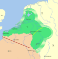
English: Map showing the approximate extent of the Old Frankish language during the 6-7th century.

Legend:

  • 1: Old Frankish language area (ancestral to Old Low Franconian and Old High Franconian)
  • 2. Northsea Germanic dialects (ancestral to Old English, Old Frisian, Old Saxon)
  • 3. Elbe Germanic dialects (partially ancestral to Old High German)
  • Red line: the Somme-Aisne-line, north of which Germanic toponymns dominate.
  • Yellow line: approximative extent of the High German consonant shift during the Early Medieval Period. (note: its position is not identical to that of the later Benratherline, as the current westernmost position of this isogloss is due to 12th and 13th century developments)

Based on:

  • Kerkhof, P.A. [Peter Alexander]: Language, Law and Loanwords in Early Medieval Gaul: Language Contact and Studies in Gallo-Romance phonology, Doctoral Thesis, Leiden, 2018, pp. 24 [it's either p. or other pages are missing]. [1]
  • Ryckeboer, H.: Het Nederlands in Noord-Frankrijk: Sociolinguïstische, dialectologische en contactlinguïstische aspecten, Gent, 1997, pp. 183-4. [2]
  • Cowan, H.K.J: Oudoostnederfrankisch of oostelijk Oudnederlands? [Old East Low Franconian/Frankish or eastern Old Netherlandic/Dutch?], in: Tijdschrift voor Nederlandse Taal- en Letterkunde, jaargang 71. E.J. Brill, Leiden, 1953, pp. 161-182. [3]
Data
Origem Obra do próprio
Autor Vlaemink

Licenciamento

Eu, titular dos direitos de autor desta obra, publico-a com a seguinte licença:
w:pt:Creative Commons
atribuição partilha nos termos da mesma licença
A utilização deste ficheiro é regulada nos termos da licença Creative Commons Atribuição-CompartilhaIgual 4.0 Internacional.
Pode:
  • partilhar – copiar, distribuir e transmitir a obra
  • recombinar – criar obras derivadas
De acordo com as seguintes condições:
  • atribuição – Tem de fazer a devida atribuição da autoria, fornecer uma hiperligação para a licença e indicar se foram feitas alterações. Pode fazê-lo de qualquer forma razoável, mas não de forma a sugerir que o licenciador o apoia ou subscreve o seu uso da obra.
  • partilha nos termos da mesma licença – Se remisturar, transformar ou ampliar o conteúdo, tem de distribuir as suas contribuições com a mesma licença ou uma licença compatível com a original.

Legendas

Adicione uma explicação de uma linha do que este ficheiro representa
Map showing the approximate extent of the Old Frankish language during the 6-7th century.

Elementos retratados neste ficheiro

retrata

2906c851ad61676b66504690b8e35c4a349583a2

488 291 byte

2 053 pixel

2 038 pixel

Histórico do ficheiro

Clique uma data e hora para ver o ficheiro tal como ele se encontrava nessa altura.

Data e horaMiniaturaDimensõesUtilizadorComentário
atual11h01min de 13 de janeiro de 2022Miniatura da versão das 11h01min de 13 de janeiro de 20222 038 × 2 053 (477 kB)VlaeminkAdded the initial (pre-High Medieval) extent of the Second Germanic consonant shift.
17h24min de 12 de janeiro de 2022Miniatura da versão das 17h24min de 12 de janeiro de 20222 038 × 2 053 (471 kB)VlaeminkUploaded own work with UploadWizard

A seguinte página usa este ficheiro:

Utilização global do ficheiro

Metadados