
Ficheiro:Amarnamap.png

Dimensões desta antevisão: 772 × 599 píxeis. Outras resoluções: 309 × 240 píxeis | 619 × 480 píxeis | 782 × 607 píxeis.
Imagem numa resolução maior (782 × 607 píxeis, tamanho: 743 kB, tipo MIME: image/png)
|
|
Esta imagem provém do Wikimedia Commons, um acervo de conteúdo livre da Wikimedia Foundation que pode ser utilizado por outros projetos.
|
Descrição do ficheiro
| Descrição |
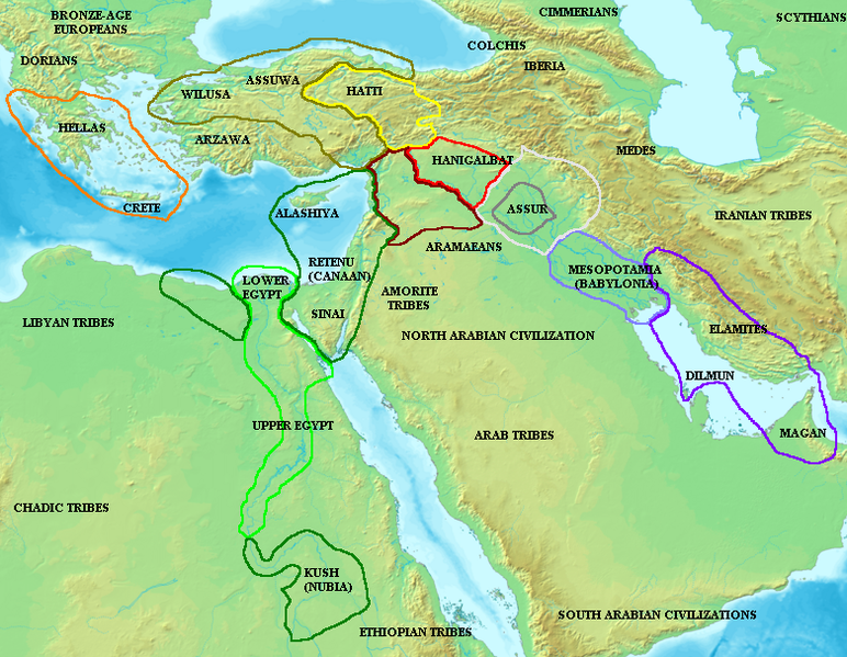
English: Map of the ancient Near East during the Amarna period, showing the great powers of the period: Egypt (green), Hatti (yellow), the Kassite kingdom of Babylon (purple), Assyria (grey), and Mittani (red). Lighter areas show direct control, darker areas represent spheres of influence. The extent of the Achaean/Mycenaean civilization is shown in orange.
On the map above: the territory between Medes and Iberia was called Ararat or Armenia, around the lake Van.
Русский: Карта Восточного Средиземноморья в Амарнский период (XIV век до н. э.). Территория Египта обведена зелёным, Митанни — красным, Хатти — жёлтым (покорённые ими территории обозначены более тёмными контурами того же цвета). |
||
| Data | |||
| Origem |
|
||
| Autor | Briangotts |

Licenciamento
Eu, titular dos direitos de autor desta obra, publico-a com a seguinte licença:

|
É concedida permissão para copiar, distribuir e/ou modificar este documento nos termos da Licença de Documentação Livre GNU, versão 1.2 ou qualquer versão posterior publicada pela Free Software Foundation; sem Secções Invariantes, sem textos de Capa e sem textos de Contra-Capa. É incluída uma cópia da licença na secção intitulada GNU Free Documentation License. |
| A utilização deste ficheiro é regulada nos termos da licença Creative Commons - Atribuição-CompartilhaIgual 3.0 Não Adaptada. | ||
| ||
| Esta marca de licenciamento foi adicionada a este ficheiro durante a atualização da licença GFDL. |
Histórico do ficheiro
Clique uma data e hora para ver o ficheiro tal como ele se encontrava nessa altura.
| Data e hora | Miniatura | Dimensões | Utilizador | Comentário | |
|---|---|---|---|---|---|
| atual | 09h55min de 3 de dezembro de 2006 | | 782 × 607 (743 kB) | Electionworld | {{ew|en|Briangotts}} Map of the ancient Near East during the Amarna period, showing the great powers of the period: Egypt (green), Hatti (yellow), the Kassite kingdom of Babylon (purple), Assyria (grey), and Mittani (red). |
Utilização local do ficheiro
A seguinte página usa este ficheiro:
Utilização global do ficheiro
As seguintes wikis usam este ficheiro:
- am.wikipedia.org
- ar.wikipedia.org
- ast.wikipedia.org
- ba.wikipedia.org
- be.wikipedia.org
- bs.wikipedia.org
- ca.wikipedia.org
- diq.wikipedia.org
- el.wikipedia.org
- en.wikipedia.org
- es.wikipedia.org
- eu.wikipedia.org
- fi.wikipedia.org
- fr.wikipedia.org
- fy.wikipedia.org
- he.wikipedia.org
- hu.wikipedia.org
- hy.wikipedia.org
- hyw.wikipedia.org
- id.wikipedia.org
- ja.wikipedia.org
- jv.wikipedia.org
- mk.wikipedia.org
- ml.wikipedia.org
- nl.wikipedia.org
Ver mais utilizações globais deste ficheiro.