
Ficheiro:British Isles.svg

Dimensões desta antevisão em PNG do ficheiro SVG: 361 × 600 píxeis Outras resoluções: 144 × 240 píxeis | 289 × 480 píxeis | 462 × 768 píxeis | 616 × 1 024 píxeis | 1 232 × 2 048 píxeis | 1 300 × 2 160 píxeis.
Imagem numa resolução maior (ficheiro SVG, de 1 300 × 2 160 píxeis, tamanho: 154 kB)
|
|
Esta imagem provém do Wikimedia Commons, um acervo de conteúdo livre da Wikimedia Foundation que pode ser utilizado por outros projetos.
|
Descrição do ficheiro
| Descrição |
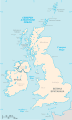
An SVG map of the British Isles, with the largest islands and archipelagos labelled. Always considered part of the British Isles
Sometimes considered part of the British Isles
Other lands |
| Origem | Obra do próprio |
| Autor | Smurrayinchester |
| SVG desenvolvimento | Esta carta geográfica inválida foi criada com o Other tools Este Esta carta geográfica é traduzido usando elementos SVG switch: todas as traduções são armazenadas no mesmo arquivo. |
}
Licenciamento
Eu, titular dos direitos de autor desta obra, publico-a com a seguinte licença:

|
É concedida permissão para copiar, distribuir e/ou modificar este documento nos termos da Licença de Documentação Livre GNU, versão 1.2 ou qualquer versão posterior publicada pela Free Software Foundation; sem Secções Invariantes, sem textos de Capa e sem textos de Contra-Capa. É incluída uma cópia da licença na secção intitulada GNU Free Documentation License. |
| A utilização deste ficheiro é regulada nos termos da licença Creative Commons - Atribuição-CompartilhaIgual 3.0 Não Adaptada. | ||
| ||
| Esta marca de licenciamento foi adicionada a este ficheiro durante a atualização da licença GFDL. |
Derivative works
-
 македонски
 -
 Flag map (1801–1922)


derivative works
Obras derivadas deste ficheiro: British Isles mk.svg
Histórico do ficheiro
Clique uma data e hora para ver o ficheiro tal como ele se encontrava nessa altura.
| Data e hora | Miniatura | Dimensões | Utilizador | Comentário | |
|---|---|---|---|---|---|
| atual | 15h33min de 10 de fevereiro de 2019 | | 1 300 × 2 160 (154 kB) | MSG17 | Uploaded from SVG Translate. |
| 14h56min de 13 de outubro de 2018 |  | 1 300 × 2 160 (141 kB) | Seb35 | small bug: translations have to be before the default text else the PNG rendering selects the default text | |
| 14h51min de 13 de outubro de 2018 |  | 1 300 × 2 160 (141 kB) | Seb35 | added French translation | |
| 14h50min de 20 de maio de 2014 |  | 1 300 × 2 160 (135 kB) | NikNaks | More cleaning. File could still be a lot smaller than it currently is | |
| 03h02min de 20 de maio de 2014 |  | 1 300 × 2 160 (152 kB) | NikNaks | Malay translation | |
| 02h36min de 20 de maio de 2014 |  | 1 300 × 2 160 (148 kB) | NikNaks | Cleaning unfortunately lost detail. Will have to return to later | |
| 02h22min de 20 de maio de 2014 |  | 1 297 × 2 160 (37 kB) | NikNaks | Attempting to clean up the file before translation | |
| 12h37min de 20 de agosto de 2006 |  | 1 297 × 2 160 (196 kB) | Smurrayinchester | An SVG map of the British Isles, with the largest islands and archipelagos labeled. {{legend|#fff0de|Always considered part of the British Isles|border=#ffffff}} {{legend|#ffb380|Sometimes considered part of the British Isles|border=#ffffff}} {{legend|#e |
Utilização local do ficheiro
Não há nenhuma página que use este ficheiro.
Utilização global do ficheiro
As seguintes wikis usam este ficheiro:
- ar.wikipedia.org
- az.wikipedia.org
- be.wikipedia.org
- bs.wikipedia.org
- ceb.wikipedia.org
- ckb.wikipedia.org
- da.wikipedia.org
- en.wikipedia.org
- Geography of the Isle of Man
- Burhou
- Talk:International Football Association Board
- Module:Location map/data/British Isles/doc
- List of offshore wind farms in the Irish Sea
- Siege of St Andrews Castle
- User:Malpass93/sandbox
- Module:Location map/data/British Isles
- 2014 Senior Open Championship
- 2017 Senior Open Championship
- 2018 Eisenhower Trophy
- User:Grover cleveland/History of the laws of the game/List of IFAB meetings
- User:Grover cleveland/English managers
- 2018 Espirito Santo Trophy
- 1965 European Amateur Team Championship
- 1975 European Amateur Team Championship
- 1981 European Amateur Team Championship
- 1989 European Amateur Team Championship
- 1997 European Amateur Team Championship
- 2005 European Amateur Team Championship
- 2007 European Amateur Team Championship
- 2009 European Amateur Team Championship
- 1971 European Ladies' Team Championship
- 1979 European Ladies' Team Championship
- 1987 European Ladies' Team Championship
- 1991 European Ladies' Team Championship
- 2013 European Ladies' Team Championship
- 2021 European Ladies' Team Championship
- 2022 European Amateur Team Championship
- 2022 European Ladies' Team Championship
- 2013 Senior Open Championship
- 2012 Senior Open Championship
- 2011 Senior Open Championship
- 2008 Senior Open Championship
- 2006 Senior Open Championship
- 2002 Senior British Open
- 2001 Senior British Open
- 2000 Senior British Open
- 2022 Senior Open Championship
- User:Erik Sergeant/sandbox 2
- 2023 Senior Open Championship
- Module:Location map/data/British Isles/sandbox
- Draft:2024 Monoposto Championship
Ver mais utilizações globais deste ficheiro.