
Ficheiro:British main lines railway diagram.png

Dimensões desta antevisão: 421 × 599 píxeis. Outras resoluções: 168 × 240 píxeis | 337 × 480 píxeis | 539 × 768 píxeis | 719 × 1 024 píxeis | 2 464 × 3 508 píxeis.
Imagem numa resolução maior (2 464 × 3 508 píxeis, tamanho: 558 kB, tipo MIME: image/png)
|
|
Esta imagem provém do Wikimedia Commons, um acervo de conteúdo livre da Wikimedia Foundation que pode ser utilizado por outros projetos.
|

|
File:British main lines railway diagram.svg é uma versão vetorial deste ficheiro. Ela deve ser usada em vez desta imagem em formato raster, se não for de qualidade inferior.
File:British main lines railway diagram.png → File:British main lines railway diagram.svg
Para mais informações, consulte Ajuda:SVG. |
 |
Descrição do ficheiro
| Descrição |
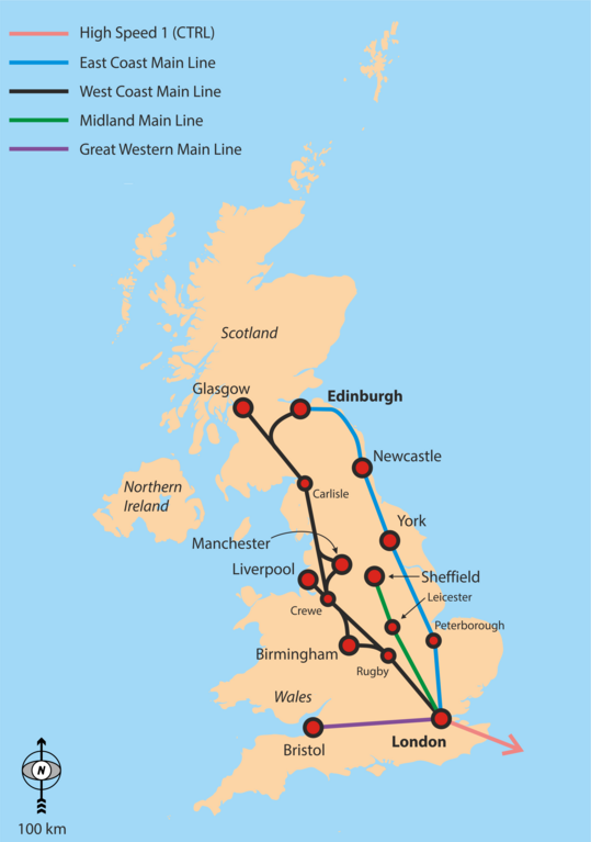
English: Simple overview map of the WCML, ECML, Midland Main Line and CTRL. |
| Data | |
| Origem | Obra do próprio |
| Autor | Classical geographer |
Background is File:Uk_outline_map.png; ECML and WCML are based on File:Uk outline map with ECML railway.PNG and File:Uk outline map with WCML railway.PNG.
Licenciamento
Eu, titular dos direitos de autor desta obra, publico-a com a seguinte licença:
A utilização deste ficheiro é regulada nos termos da licença Creative Commons - Atribuição-CompartilhaIgual 3.0 Não Adaptada.
- Pode:
- partilhar – copiar, distribuir e transmitir a obra
- recombinar – criar obras derivadas
- De acordo com as seguintes condições:
- atribuição – Tem de fazer a devida atribuição da autoria, fornecer uma hiperligação para a licença e indicar se foram feitas alterações. Pode fazê-lo de qualquer forma razoável, mas não de forma a sugerir que o licenciador o apoia ou subscreve o seu uso da obra.
- partilha nos termos da mesma licença – Se remisturar, transformar ou ampliar o conteúdo, tem de distribuir as suas contribuições com a mesma licença ou uma licença compatível com a original.
Histórico do ficheiro
Clique uma data e hora para ver o ficheiro tal como ele se encontrava nessa altura.
| Data e hora | Miniatura | Dimensões | Utilizador | Comentário | |
|---|---|---|---|---|---|
| atual | 17h29min de 6 de setembro de 2016 | | 2 464 × 3 508 (558 kB) | Rob984 | Showing all of Ireland but not even part of France is odd. Especially considering there are UK-France high speed routes. |
| 04h48min de 6 de setembro de 2016 |  | 2 503 × 3 627 (849 kB) | Classical geographer | Added Western Main Line. Decreased font size of junctions. Note the map is still intended for a quick overview, perhaps at the top of an article. | |
| 07h29min de 22 de julho de 2010 |  | 1 333 × 1 777 (188 kB) | Classical geographer | Chester should have been Crewe. | |
| 19h17min de 21 de julho de 2010 |  | 1 666 × 2 221 (904 kB) | Classical geographer | Resized, because was over 12.5 million pixels. | |
| 19h15min de 21 de julho de 2010 |  | 3 333 × 4 444 (600 kB) | Classical geographer | {{Information |Description={{en|1=Simple overview map of the WCML, ECML, Midland Main Line and CTRL.}} |Source={{own}} |Author=Classical geographer |Date=2010-07-21 |Permission= |other_versions= }} Background is [[:File:Uk_ou |
Utilização local do ficheiro
A seguinte página usa este ficheiro:
Utilização global do ficheiro
As seguintes wikis usam este ficheiro:
- en.wikipedia.org
- fa.wikipedia.org
- it.wikipedia.org
- ja.wikipedia.org
- nl.wikipedia.org
- no.wikipedia.org
- pnb.wikipedia.org
- ru.wikipedia.org
- ur.wikipedia.org
- zh.wikipedia.org