
Ficheiro:Europe 1815 map en.png

Dimensões desta antevisão: 800 × 526 píxeis. Outras resoluções: 320 × 211 píxeis | 640 × 421 píxeis | 1 024 × 674 píxeis | 1 280 × 842 píxeis | 2 284 × 1 503 píxeis.
Imagem numa resolução maior (2 284 × 1 503 píxeis, tamanho: 1,08 MB, tipo MIME: image/png)
|
|
Esta imagem provém do Wikimedia Commons, um acervo de conteúdo livre da Wikimedia Foundation que pode ser utilizado por outros projetos.
|
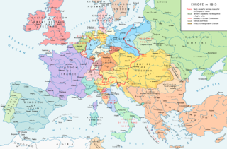
Map of Europe 1815, After the Congress of Vienna.
Descrição do ficheiro
| Descrição |
English: Europe 1815. Political situation after the Congress of Vienna in June 1815. Please don't alter the map when you think there is something not written or depicted correctly. Leave a message at the talk page of the file. After a verificiation and a possible discussion, I will upload a new map version with all new changes. This prevents an unnecessary waste of disk space and ensures a good result, aesthetically and content-wise. - The author. Español: Mapa de Europa en 1815. Situación política tras el Congreso de Viena en junio de 1815.
Deutsch: Europa 1815. Politische Lage nach dem Wiener Kongress im Juni 1815.
Bitte die Karte bei Änderungs- und Korrekturwünschen nicht selbst verändern, sondern eine Anmerkung im Diskussionsbereich der Bilddatei hinterlassen. Nach einer Prüfung und ggfs. Diskussion werden evtl. Änderungen von mir zusammengefasst eingearbeitet. Das vermeidet unnötige Speicherplatz-Verschwendung und gewährleistet ein ästhetisch ansprechendes und inhaltlich korrektes Ergebnis. - Der Urheber. Français : Carte de l'Europe en 1815. Situation politique après le Congrès de Vienne en juin 1815.
Italiano: Mappa dell'Europa nel 1815. Situazione politica dopo il Congresso di Vienna nel giugno 1815.
Русский: Карта Европы 1815 года. Политическая ситуация после Венского конгресса в июне 1815 года.
Português: Mapa da Europa em 1815. Situação política após o Congresso de Viena em junho de 1815. |
| Data | |
| Origem |
Obra do próprio. Source of Information: Historical atlases – Map "1815 - L'Europe après le Congrès de Vienne" (Author unknown)(Link) – Ramsay Muir, George Philip (ed.): Philip's New School Atlas of Universal History, George Philip & Son, Ltd., London 1928 – Dr. Walter Leisering (ed.): Putzger Historischer Weltatlas, Cornelsen Verlag, Berlin 1992, ISBN 3-464-00176-8 – Bayerischer Schulbuch-Verlag (ed.): Großer Historischer Weltatlas, Dritter Teil, Neuzeit, Bayerischer Schulbuch-Verlag, München 1981, ISBN 3-7627-6021-7. – Prof. Dr. Hans-Erich Stier, Prof. Dr. Ernst Kirsten a. o. (ed.): Großer Atlas zur Weltgeschichte, Orbis Verlag, München 1990, ISBN 3-7627-6021-7 Other publications – Reinhard Stauber: Der Wiener Kongress, Böhlau Verlag, Wien/Köln/Weimar 2014, ISBN 978-3-8252-4095-0 – Thierry Lentz: 1815. Der Wiener Kongress und die Neugründung Europas, Siedler Verlag, München 2014, ISBN 978-3-8275-0027-4 |
| Autor | Alexander Altenhof |
| Outras versões |
|

Recompressed without quality loss with OptiPNG (1.36 MB > 1.06 MB)
Licenciamento
Eu, titular dos direitos de autor desta obra, publico-a com a seguinte licença:
A utilização deste ficheiro é regulada nos termos da licença Creative Commons Atribuição-CompartilhaIgual 4.0 Internacional.
- Pode:
- partilhar – copiar, distribuir e transmitir a obra
- recombinar – criar obras derivadas
- De acordo com as seguintes condições:
- atribuição – Tem de fazer a devida atribuição da autoria, fornecer uma hiperligação para a licença e indicar se foram feitas alterações. Pode fazê-lo de qualquer forma razoável, mas não de forma a sugerir que o licenciador o apoia ou subscreve o seu uso da obra.
- partilha nos termos da mesma licença – Se remisturar, transformar ou ampliar o conteúdo, tem de distribuir as suas contribuições com a mesma licença ou uma licença compatível com a original.

|
Esta imagem de mapas (ou todas as imagens neste artigo ou categoria) deveriam ser recriadas usando gráficos vectoriais, como ficheiros SVG. Isto tem várias vantagens; veja as Commons:Media for cleanup|imagens para rever para mais informações. Se já criou um ficheiro SVG desta imagem, por favor, carregue-o. Depois do novo ficheiro SVG ter sido carregado, substitua aqui esta predefinição pela predefinição {{vector version available|nome da nova imagem.svg}}.
|
Histórico do ficheiro
Clique uma data e hora para ver o ficheiro tal como ele se encontrava nessa altura.
| Data e hora | Miniatura | Dimensões | Utilizador | Comentário | |
|---|---|---|---|---|---|
| atual | 23h36min de 14 de abril de 2017 | | 2 284 × 1 503 (1,08 MB) | KaterBegemot | Corrected "K. of Bavaria" caption / minor changes |
| 21h50min de 11 de setembro de 2016 |  | 2 284 × 1 503 (1,36 MB) | KaterBegemot | Kingdom of Spain same green color like in the other maps | |
| 21h38min de 11 de setembro de 2016 |  | 2 284 × 1 503 (1,06 MB) | KaterBegemot | Deleted black border at Austrian part of the German Confederation border, P. of Monaco smaller, corrected border at Tarnopol area, changed spacing of K. of Netherlands text | |
| 11h23min de 20 de julho de 2016 |  | 2 284 × 1 503 (1,07 MB) | KaterBegemot | {{Information |Description ={{en|1=Europe 1815. Political situation after the Congress of Vienna in June 1815.<br> ''Please don't alter the map, when you think there something not written or depicted correclty. Leave a mes... |
Utilização local do ficheiro
Não há nenhuma página que use este ficheiro.
Utilização global do ficheiro
As seguintes wikis usam este ficheiro:
- avk.wikipedia.org
- azb.wikipedia.org
- bg.wikipedia.org
- bs.wikipedia.org
- cs.wikipedia.org
- da.wikipedia.org
- el.wikipedia.org
- eml.wikipedia.org
- en.wikipedia.org
- Europe
- History of Europe
- 1810s
- History of Austria
- Congress of Vienna
- Napoleonic Wars
- History of the Czech lands
- Klemens von Metternich
- Karl August von Hardenberg
- Concert of Europe
- Former countries in Europe after 1815
- Balance of power (international relations)
- Monarchies in Europe
- Federal Convention (German Confederation)
- Portal:Czech Republic
- European balance of power
- 19th century
- International relations (1814–1919)
- Timeline of Karl Marx
- Timeline of the 19th century
- User:Falcaorib
- Secret Treaty of Vienna
- Talk:Europe/Archive 11
- User:SocratesGR
- en.wikibooks.org
- en.wikiquote.org
- eo.wikipedia.org
- eo.wikiquote.org
- es.wikipedia.org
- et.wikipedia.org
- eu.wikipedia.org
- fa.wikipedia.org
- fi.wikipedia.org
- fr.wikipedia.org
Ver mais utilizações globais deste ficheiro.