
Ficheiro:Ferry light trail, Rostock.jpg

Dimensões desta antevisão: 800 × 450 píxeis. Outras resoluções: 320 × 180 píxeis | 640 × 360 píxeis | 1 024 × 576 píxeis | 1 280 × 720 píxeis | 2 560 × 1 440 píxeis | 4 000 × 2 250 píxeis.
Imagem numa resolução maior (4 000 × 2 250 píxeis, tamanho: 7,76 MB, tipo MIME: image/jpeg)
|
|
Esta imagem provém do Wikimedia Commons, um acervo de conteúdo livre da Wikimedia Foundation que pode ser utilizado por outros projetos.
|
Descrição do ficheiro
| Descrição |
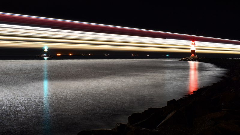
English: Light trail of the largest German ferry M/S Mecklenburg-Vorpommern on its way from Rostock to Trelleborg: Aperture f/20, Exposure time 219 seconds
العربية: مسار أضواء أكبر عبارة ألمانية في وانيموند في ألمانيا
বাংলা: বৃহত্তম জার্মান ফেরি এম/এস মেকলেনবার্গ-ভোর্পোমারনের বাতির চিহ্নরেখা। বার্নামুন্ডে, জার্মানি।
Bosanski: Svjetlosni trag najvećeg njemačkog trajekta M/S Mecklenburg-Vorpommern u Warnemündeu, Njemačka
Čeština: Světelná stopa největšího německého trajektu M/S Mecklenburg-Vorpommern v přístavu města Warnemünde u Baltského moře
Deutsch: Lichtspur der größten deutschen Fähre M/S Mecklenburg-Vorpommern auf dem Weg von Rostock nach Trelleborg: Blende f/20, Belichtungszeit 219 Sekunden
Español: Sendero de luz del transbordador alemán M/S Mecklenburg-Vorpommern en Warnemünde, Alemania: Apertura f/20, Velocidad de obturación 219 segundos
Esperanto: Luma spuro de la plej granda germana pramo "M/S Meklenburgo-Antaŭpomerio" en Warnemünde, Germanio
Français : Les traces lumineuses du Mecklenburg-Vorpommern, l'un des plus larges ferries allemands, à Warnemünde
Magyar: A legnagyobb német kompnak, az MS Mecklenburg-Vorpommernnek a fénycsíkja (Warnemünde, Németország)
Nederlands: Lichtspoor van de spoorpont Mecklenburg-Vorpommern, de grootste Duitse veerboot, onderweg van Rostock naar Trelleborg
Polski: Ślad światła największego niemieckiego promu M/S Mecklenburg-Vorpommern wypływającego z Rostocku do Trelleborga: Apertura f/20, Czas naświetlania 219 sekund
Português: Rastro de luz da maior balsa alemã, M/S Mecklenburg-Vorpommern, em Warnemünde, Alemanha
Українська: Світловий слід від найбільшого німецького порому M/S Мекленбург-Передня Померанія на шляху від Ростока до Треллеборга: Діафрагма f/20, час витримки 219 секунд |
| Data | Tirada em 2 de janeiro de 2021, 22:12:18 |
| Origem | Obra do próprio |
| Autor | Radomianin |
| Outras versões |
|

| Localização da câmara | | Esta e outras imagens nas suas localizações em: OpenStreetMap |
|---|
| Atribuição (requerido pela licença) | © Radomianin / Wikimedia Commons / CC BY-SA 4.0 |
| Using this image | You can use this image file free of charge under the terms of the free license CC BY-SA 4.0. In particular, this means:
|
| Editing this image |
|
The photo was taken from the east mole in the district Hohe Düne, view from southeast.
Avaliação
|
Esta imagem foi escolhida como imagem do dia na wiki Wikimedia Commons para 20 de maio de 2021. Teve a seguinte legenda: Português: Rastro de luz da maior balsa alemã, M/S Mecklenburg-Vorpommern, em Warnemünde, Alemanha Outros idiomas:
Bosanski: Svjetlosni trag najvećeg njemačkog trajekta M/S Mecklenburg-Vorpommern u Warnemündeu, Njemačka Čeština: Světelná stopa největšího německého trajektu M/S Mecklenburg-Vorpommern v přístavu města Warnemünde u Baltského moře Esperanto: Luma spuro de la plej granda germana pramo "M/S Meklenburgo-Antaŭpomerio" en Warnemünde, Germanio Français : Les traces lumineuses du Mecklenburg-Vorpommern, l'un des plus larges ferries allemands, à Warnemünde Magyar: A legnagyobb német kompnak, az MS Mecklenburg-Vorpommernnek a fénycsíkja (Warnemünde, Németország) Nederlands: Lichtspoor van de spoorpont Mecklenburg-Vorpommern, de grootste Duitse veerboot, onderweg van Rostock naar Trelleborg Polski: Ślad światła największego niemieckiego promu M/S Mecklenburg-Vorpommern w Warnemünde, Niemcy Português: Rastro de luz da maior balsa alemã, M/S Mecklenburg-Vorpommern, em Warnemünde, Alemanha Українська: Світловий слід від найбільшого німецького порому M/S Мекленбург-Передня Померанія у Варнемюнде, Німеччина বাংলা : বৃহত্তম জার্মান ফেরি এম/এস মেকলেনবার্গ-ভোর্পোমারনের বাতির চিহ্নরেখা। বার্নামুন্ডে, জার্মানি। العربية : مسار أضواء أكبر عبارة ألمانية في وانيموند في ألمانيا. |
Licenciamento
Eu, titular dos direitos de autor desta obra, publico-a com a seguinte licença:
A utilização deste ficheiro é regulada nos termos da licença Creative Commons Atribuição-CompartilhaIgual 4.0 Internacional.
- Pode:
- partilhar – copiar, distribuir e transmitir a obra
- recombinar – criar obras derivadas
- De acordo com as seguintes condições:
- atribuição – Tem de fazer a devida atribuição da autoria, fornecer uma hiperligação para a licença e indicar se foram feitas alterações. Pode fazê-lo de qualquer forma razoável, mas não de forma a sugerir que o licenciador o apoia ou subscreve o seu uso da obra.
- partilha nos termos da mesma licença – Se remisturar, transformar ou ampliar o conteúdo, tem de distribuir as suas contribuições com a mesma licença ou uma licença compatível com a original.
Histórico do ficheiro
Clique uma data e hora para ver o ficheiro tal como ele se encontrava nessa altura.
| Data e hora | Miniatura | Dimensões | Utilizador | Comentário | |
|---|---|---|---|---|---|
| atual | 12h14min de 20 de fevereiro de 2021 | | 4 000 × 2 250 (7,76 MB) | Radomianin | image cropping changed |
| 14h35min de 17 de fevereiro de 2021 |  | 4 047 × 2 277 (7,21 MB) | Radomianin | Uploaded own work with UploadWizard |
Utilização local do ficheiro
As seguintes 2 páginas usam este ficheiro:
Utilização global do ficheiro
As seguintes wikis usam este ficheiro:
- alt.wikipedia.org
- av.wikipedia.org
- be-tarask.wikipedia.org
- bn.wikipedia.org
- crh.wikipedia.org
- cv.wikipedia.org
- fr.wikipedia.org
- hu.wikipedia.org
- hy.wikipedia.org
- ka.wikipedia.org
- ko.wikipedia.org
- lbe.wikipedia.org
- lez.wikipedia.org
- mk.wikipedia.org
- os.wikipedia.org
- pl.wikipedia.org
- ru.wikipedia.org
- ru.wikinews.org
- sah.wikipedia.org
- uk.wikipedia.org
- vep.wikipedia.org
- zh.wikipedia.org