
Ficheiro:Huntingdonshire UK locator map.svg

Dimensões desta antevisão em PNG do ficheiro SVG: 533 × 600 píxeis Outras resoluções: 213 × 240 píxeis | 426 × 480 píxeis | 682 × 768 píxeis | 910 × 1 024 píxeis | 1 820 × 2 048 píxeis | 1 125 × 1 266 píxeis.
Imagem numa resolução maior (ficheiro SVG, de 1 125 × 1 266 píxeis, tamanho: 894 kB)
|
|
Esta imagem provém do Wikimedia Commons, um acervo de conteúdo livre da Wikimedia Foundation que pode ser utilizado por outros projetos.
|
| Descrição |
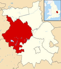
Map of Cambridgeshire, UK with Huntingdonshire highlighted. Equirectangular map projection on WGS 84 datum, with N/S stretched 160% |
| Data | |
| Origem |
|
| Autor | Nilfanion, created using Ordnance Survey data |
| Permissão (Reutilizar este ficheiro) |
A utilização deste ficheiro é regulada nos termos da licença Creative Commons - Atribuição-CompartilhaIgual 3.0 Não Adaptada. Atribuição: Contains Ordnance Survey data © Crown copyright and database right
|
Histórico do ficheiro
Clique uma data e hora para ver o ficheiro tal como ele se encontrava nessa altura.
| Data e hora | Miniatura | Dimensões | Utilizador | Comentário | |
|---|---|---|---|---|---|
| atual | 23h24min de 3 de agosto de 2011 | | 1 125 × 1 266 (894 kB) | Nilfanion | {{Information |Description=Map of Cambridgeshire, UK with Huntingdonshire highlighted. Equirectangular map projection on WGS 84 datum, with N/S stretched 160% |Source=Ordnance Survey [https |
Utilização local do ficheiro
A seguinte página usa este ficheiro:
Utilização global do ficheiro
As seguintes wikis usam este ficheiro:
- ar.wikipedia.org
- be.wikipedia.org
- bg.wikipedia.org
- cy.wikipedia.org
- da.wikipedia.org
- en.wikipedia.org
- eo.wikipedia.org
- es.wikipedia.org
- eu.wikipedia.org
- fa.wikipedia.org
- fi.wikipedia.org
- frr.wikipedia.org
- fr.wikipedia.org
- Huntingdonshire
- Stilton (Royaume-Uni)
- Huntingdon (Royaume-Uni)
- Godmanchester (Royaume-Uni)
- St Neots
- St Ives (Cambridgeshire)
- Abbots Ripton
- Kings Ripton
- Holme (Cambridgeshire)
- Ramsey (Angleterre)
- Sawtry
- Yaxley (Cambridgeshire)
- Liste des paroisses civiles du Cambridgeshire
- Modèle:Palette Huntingdonshire
- Abbotsley
- Old Weston
- Alconbury
- Alwalton
- Bluntisham
- Brampton (Cambridgeshire)
- Broughton (Cambridgeshire)
- Buckden (Cambridgeshire)
- Buckworth
- Bury (Cambridgeshire)
- Alconbury Weston
- Catworth
- Chesterton (Huntingdonshire)
- Colne (Cambridgeshire)
- Conington (Huntingdonshire)
- Covington (Cambridgeshire)
- Diddington
- Earith
- Easton (Cambridgeshire)
- Ellington (Cambridgeshire)
- Elton (Cambridgeshire)
- Farcet
- Fenstanton
Ver mais utilizações globais deste ficheiro.