
Ficheiro:Ireland.svg

Dimensões desta antevisão em PNG do ficheiro SVG: 471 × 599 píxeis Outras resoluções: 188 × 240 píxeis | 377 × 480 píxeis | 603 × 768 píxeis | 804 × 1 024 píxeis | 1 609 × 2 048 píxeis | 2 200 × 2 800 píxeis.
Imagem numa resolução maior (ficheiro SVG, de 2 200 × 2 800 píxeis, tamanho: 204 kB)
|
|
Esta imagem provém do Wikimedia Commons, um acervo de conteúdo livre da Wikimedia Foundation que pode ser utilizado por outros projetos.
|
Descrição do ficheiro
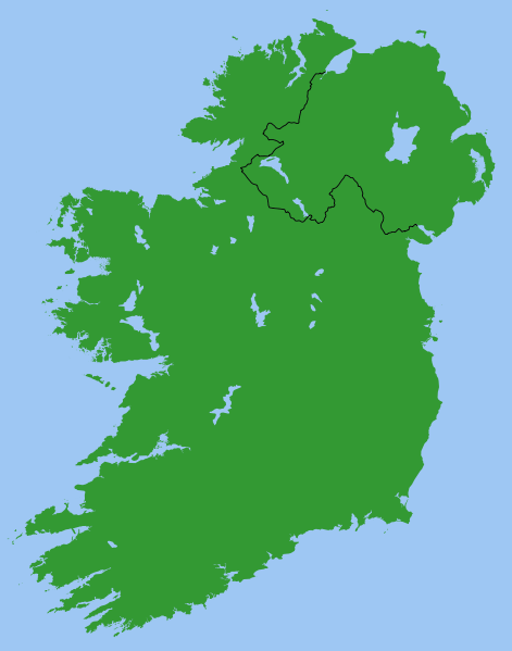
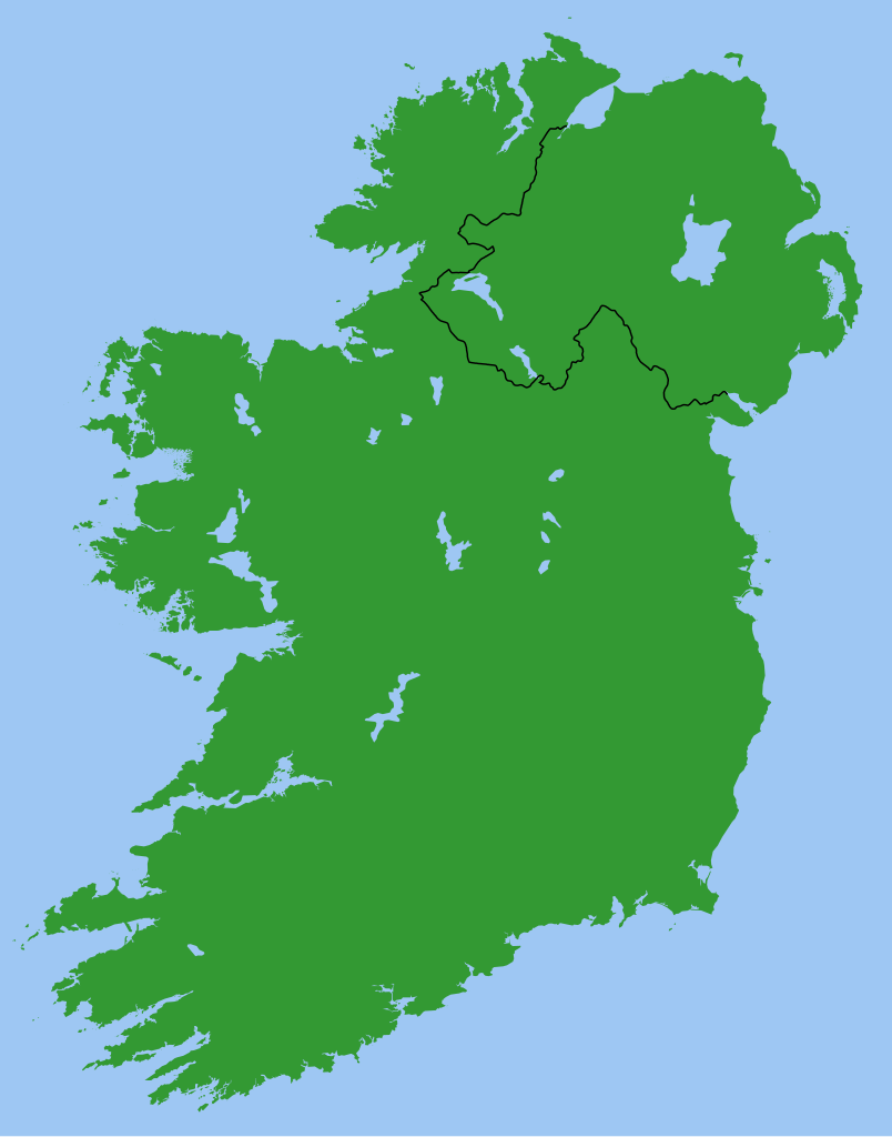
Map of Ireland, with North-South boundary delimited.
SVG should be fairly easy to alter or expand. For example the following can all be achieved with one-line CSS changes:
- You can toggle the Northern Ireland border on/off or change its thickness
- You can change any of the colours
- You can draw a border around all the land to make it more distinct from the sea
- You can hide Northern Ireland or the Republic of Ireland.
You can also do any of the following just by changing or adding/removing a few lines of SVG code:
- Zoom in on Northern Ireland, the Munster shoreline, or any other area
- Remove all the small islands (e.g. for faster rendering)
- Add drop shadows (feGaussianBlur), textured ground (feTurbulance) or topography (feDisplacementMap + feSpecularLighting)
- Add cities and towns.
- Add rivers. Anyone care to do this?
Originally derived from Image:Lough-Neagh.svg.
Licenciamento
| Eu, titular dos direitos de autor desta obra, dedico-a ao domínio público, com aplicação em todo o mundo. Nalguns países isto pode não ser legalmente possível; se assim for: Concedo a todos o direito de usar esta obra para qualquer fim, sem quaisquer condições, a menos que tais condições sejam impostas por lei. |
s]]
Histórico do ficheiro
Clique uma data e hora para ver o ficheiro tal como ele se encontrava nessa altura.
| Data e hora | Miniatura | Dimensões | Utilizador | Comentário | |
|---|---|---|---|---|---|
| atual | 21h49min de 13 de março de 2007 | | 2 200 × 2 800 (204 kB) | Nickshanks | increased default size, modified lough Erne |
| 21h19min de 13 de março de 2007 |  | 550 × 700 (204 kB) | Nickshanks | Map of Ireland, with North-South boundary delimited.<br/> SVG should be fairly easy to alter or expand. Northern Ireland is a separate group element<br/> Needs rivers adding. Anyone care to do this? Originally derived from Image:Lough-Neagh.svg. |
Utilização local do ficheiro
As seguintes 2 páginas usam este ficheiro:
Utilização global do ficheiro
As seguintes wikis usam este ficheiro:
- ca.wikipedia.org
- en.wikipedia.org
- Michael Collins (Irish leader)
- Irish Boundary Commission
- Talk:Ireland (disambiguation)
- Repartition of Ireland
- User talk:BrownHairedGirl/Archive/Archive 012
- User:Roadnote/Ireland
- Wikipedia talk:WikiProject Eurovision/Archive 3
- List of Irish Presbyteries
- National symbols of Ireland, the Republic of Ireland and Northern Ireland
- es.wikipedia.org
- fa.wikipedia.org
- fr.wikipedia.org
- ga.wikipedia.org
- it.wikipedia.org
- no.wikipedia.org
- pl.wikipedia.org
- ru.wikipedia.org
- simple.wikipedia.org
- sl.wikipedia.org
- sv.wikipedia.org