
Ficheiro:Map of part of New Holland showing the territory of Geelong and Dutigalla.png

Dimensões desta antevisão: 473 × 599 píxeis. Outras resoluções: 189 × 240 píxeis | 379 × 480 píxeis | 607 × 768 píxeis | 809 × 1 024 píxeis | 2 396 × 3 033 píxeis.
Imagem numa resolução maior (2 396 × 3 033 píxeis, tamanho: 5,32 MB, tipo MIME: image/png)
|
|
Esta imagem provém do Wikimedia Commons, um acervo de conteúdo livre da Wikimedia Foundation que pode ser utilizado por outros projetos.
|
Descrição do ficheiro
| Descrição |
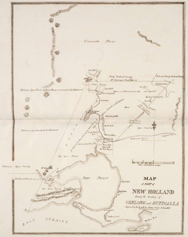
English: This is a map of the area which is now Melbourne and the Port Philip Bay in Australia, including the northerly Hinterland. The original map caption reads "MAP of PART of NEW HOLLAND Showing the Territory of GEELONG and DUTIGALLA Acquired by Treaty with the Native Chiefs, 6 June 1835." Scale: "Eight Miles to one Inch".
Deutsch: Diese Karte zeigt die Gegend des heutigen Melbourne mit der Port Philip Bay und dem nördlichen Hinterland. Der Original-Titel der Karte lautet: "KARTE eines TEILS von NEU-HOLLAND, Zeigend das Gebiet von GEELONG und DUTIGALLA, Erworben durch Vertrag mit den Eingeborenen Häuptlingen, 6. Juni 1835." Maßstab: "Acht Meilen zu einem Zoll". |
| Data | |
| Origem | http://www.nma.gov.au/__data/assets/pdf_file/0010/19189/Map_of_part_of_New_Holland.pdf via http://www.nma.gov.au/engage-learn/schools/classroom-resources/multimedia/interactives/batmania_html_version/reaction |
| Autor | Dixson Library, State Library of New South Wales, DL Q83/71 |
Licenciamento
|
Esta obra está no domínio público no seu país de origem e noutros países e áreas onde o período de proteção dos direitos de autor é igual ou inferior à vida do autor mais 100 anos. | |
| Este ficheiro foi considerado livre de restrições conhecidas devidas a direitos de autor, incluindo todos os direitos conexos. | |
This image or other work is of Australian origin and is now in the public domain because its term of copyright has expired. According to the Australian Copyright Council (ACC), ACC Information Sheet G023v19 (Duration of copyright) (January 2019).1
When using this template, please provide information of where the image was first published and who created it. |
 | |||||||||||||||||||
| Anotações | Esta imagem está anotada: Ver as anotações na wiki Commons |
Histórico do ficheiro
Clique uma data e hora para ver o ficheiro tal como ele se encontrava nessa altura.
| Data e hora | Miniatura | Dimensões | Utilizador | Comentário | |
|---|---|---|---|---|---|
| atual | 01h07min de 28 de dezembro de 2013 | | 2 396 × 3 033 (5,32 MB) | Christallkeks | cropped |
| 00h58min de 28 de dezembro de 2013 |  | 2 835 × 3 492 (7,1 MB) | Christallkeks | {{Information |Description ={{en|1=This is a map of the area which is now Melbourne and the Port Philip Bay in Australia, including the northerly Hinterland. The original map caption reads "MAP of PART of NEW HOLLAND Showing the Territory of GEELONG... |
Utilização local do ficheiro
A seguinte página usa este ficheiro:
Utilização global do ficheiro
As seguintes wikis usam este ficheiro:
- de.wikipedia.org
- en.wikipedia.org
- es.wikipedia.org