
Ficheiro:Mount Mazama eruption timeline.PNG
Imagem numa resolução maior (250 × 841 píxeis, tamanho: 187 kB, tipo MIME: image/png)
|
|
Esta imagem provém do Wikimedia Commons, um acervo de conteúdo livre da Wikimedia Foundation que pode ser utilizado por outros projetos.
|
Descrição do ficheiro
| Descrição |
|
| Origem | http://pubs.usgs.gov/fs/2002/fs092-02/ (saved as PNG) |
| Autor | U.S. GEOLOGICAL SURVEY and the NATIONAL PARK SERVICE |
| Outras versões |
    |

|
Esta imagem de geology (ou todas as imagens neste artigo ou categoria) deveriam ser recriadas usando gráficos vectoriais, como ficheiros SVG. Isto tem várias vantagens; veja as Commons:Media for cleanup|imagens para rever para mais informações. Se já criou um ficheiro SVG desta imagem, por favor, carregue-o. Depois do novo ficheiro SVG ter sido carregado, substitua aqui esta predefinição pela predefinição {{vector version available|nome da nova imagem.svg}}.
|
Licenciamento
Esta imagem está no domínio público porque ela contém materiais originalmente provenientes do Serviço Geológico dos Estados Unidos, uma agência do Departamento do Interior dos Estados Unidos. Para mais informações, veja a política oficial da USGS em relação a direitos autorais
|
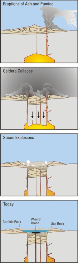
Crater Lake is an example, it is located in Oregen and was made from a valcano, making a caldera.
Histórico do ficheiro
Clique uma data e hora para ver o ficheiro tal como ele se encontrava nessa altura.
| Data e hora | Miniatura | Dimensões | Utilizador | Comentário | |
|---|---|---|---|---|---|
| atual | 05h24min de 29 de março de 2006 | 250 × 841 (187 kB) | Jkelly | Source: http://pubs.usgs.gov/fs/2002/fs092-02/ (saved as PNG) Author: U.S. GEOLOGICAL SURVEY and the NATIONAL PARK SERVICE Description: <blockquote>Cataclysmic eruption to present. Eruptions of ash and pumice: The cataclysmic eruption started from a ve |
Utilização local do ficheiro
A seguinte página usa este ficheiro:
Utilização global do ficheiro
As seguintes wikis usam este ficheiro:
- af.wikipedia.org
- an.wikipedia.org
- ar.wikipedia.org
- ast.wikipedia.org
- br.wikipedia.org
- ce.wikipedia.org
- cy.wikipedia.org
- de.wikipedia.org
- en.wikipedia.org
- en.wikiversity.org
- eo.wikipedia.org
- es.wikipedia.org
- fa.wikipedia.org
- fi.wikipedia.org
- fr.wikipedia.org
- id.wikipedia.org
- it.wikipedia.org
- ja.wikipedia.org
- ko.wikipedia.org
- lv.wikipedia.org
- min.wikipedia.org
- mk.wikipedia.org
- ml.wikipedia.org
- ru.wikipedia.org
- simple.wikipedia.org
- sk.wikipedia.org
- sr.wikipedia.org
- su.wikipedia.org
- vi.wikipedia.org
- www.wikidata.org