
Ficheiro:Mount Rainier 5845s.JPG

Dimensões desta antevisão: 800 × 234 píxeis. Outras resoluções: 320 × 94 píxeis | 640 × 187 píxeis | 1 024 × 299 píxeis | 1 280 × 374 píxeis | 2 560 × 748 píxeis | 10 016 × 2 928 píxeis.
Imagem numa resolução maior (10 016 × 2 928 píxeis, tamanho: 6,5 MB, tipo MIME: image/jpeg)
|
|
Esta imagem provém do Wikimedia Commons, um acervo de conteúdo livre da Wikimedia Foundation que pode ser utilizado por outros projetos.
|
Esta imagem foi examinada usando-se o guia para imagens de qualidade e é considerada uma Imagem de qualidade.
|
| Descrição |
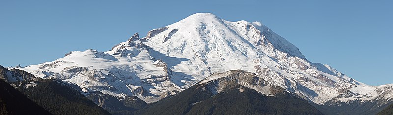
English: Mount Rainier with its main summit, Columbia Crest (14410 feet) at the center. Emmons Glacier covers most of the visible flank of the mountain. Ingraham Glacier (left) is between Gibraltar Rock (12660 feet) high on the left skyline and Disappointment Cleaver. Left of Gibraltar Rock is sharp pointed Little Tahoma (11138 feet) with Frying Pan Glacier on its flank. It is the source of Frying Pan Creek (not visible) in the valley left of forested and rounded Goat Island Mountain, in front of the Emmons Glacier. Liberty Cap (14112 feet) is visible on the right center skyline behind Russell Cliff. Curtis Ridge descends to the right from Russell Cliff. Winthrop Glacier flows right below Curtis Ridge and behind shallow Steamboat Prow (9680 feet) with the small Inter Glacier on its northeast face. The White River (not visible) comes from the Emmons Glacier and flows around the right side of Goat Island Mountain. |
| Data | 22 de outubro de 2008, 10:22:51 −07:00 |
| Origem | Obra do próprio |
| Autor | Walter Siegmund (talk) |
| Outras versões |
|


| Localização da câmara | | Esta e outras imagens nas suas localizações em: OpenStreetMap |
|---|
- Location source: Garmin GPSmap 60CSx
- Location Datum: WGS84
- Viewpoint location: Crystal Lakes Trail, Mount Rainier National Park
- Viewpoint elevation: 1602 meter (5256 ft)
- View direction: West-southwest
- Camera: Canon EOS DIGITAL REBEL XSi
- Exposure Time: 1/800
- F Number: f/11.0
- Focal Length: 120.0
- ISO Speed Rating: 400
| Esta é uma imagem retocada, o que significa que a versão original foi alterada digitalmente. Modificações: Stitched six images; adjusted levels and color balance; please see other versions in the information template for the originals. Modificações feitas por Wsiegmund.
|
©2009 Walter Siegmund
Licenciamento
Eu, titular dos direitos de autor desta obra, publico-a com as seguintes licenças:

|
É concedida permissão para copiar, distribuir e/ou modificar este documento nos termos da Licença de Documentação Livre GNU, versão 1.2 ou qualquer versão posterior publicada pela Free Software Foundation; sem Secções Invariantes, sem textos de Capa e sem textos de Contra-Capa. É incluída uma cópia da licença na secção intitulada GNU Free Documentation License. |
A utilização deste ficheiro é regulada nos termos da licença Creative Commons - Atribuição-CompartilhaIgual 3.0 Não Adaptada, 2.5 Genérica, 2.0 Genérica e 1.0 Genérica.
- Pode:
- partilhar – copiar, distribuir e transmitir a obra
- recombinar – criar obras derivadas
- De acordo com as seguintes condições:
- atribuição – Tem de fazer a devida atribuição da autoria, fornecer uma hiperligação para a licença e indicar se foram feitas alterações. Pode fazê-lo de qualquer forma razoável, mas não de forma a sugerir que o licenciador o apoia ou subscreve o seu uso da obra.
- partilha nos termos da mesma licença – Se remisturar, transformar ou ampliar o conteúdo, tem de distribuir as suas contribuições com a mesma licença ou uma licença compatível com a original.
Pode escolher a licença que quiser.
| Anotações | Esta imagem está anotada: Ver as anotações na wiki Commons |
Histórico do ficheiro
Clique uma data e hora para ver o ficheiro tal como ele se encontrava nessa altura.
| Data e hora | Miniatura | Dimensões | Utilizador | Comentário | |
|---|---|---|---|---|---|
| atual | 17h07min de 17 de março de 2009 | 10 016 × 2 928 (6,5 MB) | Wsiegmund | Losslessly cropped image a bit more on left. | |
| 04h57min de 17 de março de 2009 | 10 038 × 2 928 (6,52 MB) | Wsiegmund | Removed spots; cropped image a bit. | ||
| 04h40min de 13 de março de 2009 | 10 075 × 2 928 (6,52 MB) | Wsiegmund | {{Information |Description = {{en|Mount Rainier with its main summit, Columbia Crest (14410 feet) at the center. Emmons Glacier covers most of the visible flank of the mountain. Ingraham Glacier (left) is between Gibraltar Rock (12660 feet) high on th |
Utilização local do ficheiro
As seguintes 2 páginas usam este ficheiro:
Utilização global do ficheiro
As seguintes wikis usam este ficheiro:
- en.wikipedia.org
- fr.wikipedia.org