
Ficheiro:Obcine Slovenija 2007 4col.svg

Dimensões desta antevisão em PNG do ficheiro SVG: 800 × 522 píxeis Outras resoluções: 320 × 209 píxeis | 640 × 418 píxeis | 1 024 × 668 píxeis | 1 280 × 835 píxeis | 2 560 × 1 670 píxeis | 2 613 × 1 705 píxeis.
Imagem numa resolução maior (ficheiro SVG, de 2 613 × 1 705 píxeis, tamanho: 2,36 MB)
|
|
Esta imagem provém do Wikimedia Commons, um acervo de conteúdo livre da Wikimedia Foundation que pode ser utilizado por outros projetos.
|
Descrição do ficheiro
| Descrição |
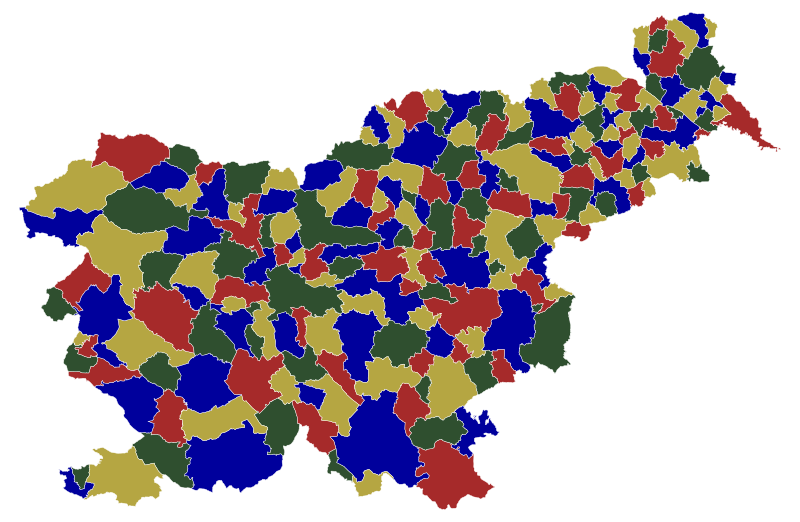
English: Map of the municipalities (občine) of the Republic of Slovenia, as since May 2006 (210 units), colored by 4 colors. Note that there are 210 municipalities, but there are 212 regions on this map, since the Zagorje ob Savi municipality and Gorenja vas - Poljane municipality have exclaves south of the main part. Although with this stricter restriction the 210-vertex graph was non-planar, it was fortunately still 4-colorable. So this is both an example of the 4 color theorem for 212 regions, and valid 4-color map for Slovenian municipalities. |
| Data | |
| Origem | Source of the public data is GURS (Geodetska uprava Republike Slovenije or Surveying and Mapping Authority of the Republic of Slovenia). Converted from Shapefile to SVG with shp2svg and prepared for Wikipedia, input matrix prepared from SVG adjacency points, then fed to the A. Dharwadker's Vertex Coloring Algorithm which produced text output, which was incorporated back to SVG by romanm (talk). |
| Autor | See above. |
| Permissão (Reutilizar este ficheiro) |
Public domain. See Image:Obcine Slovenija 2006.svg for an explanation. |
| Outras versões |
|


Licenciamento
| Eu, titular dos direitos de autor desta obra, dedico-a ao domínio público, com aplicação em todo o mundo. Nalguns países isto pode não ser legalmente possível; se assim for: Concedo a todos o direito de usar esta obra para qualquer fim, sem quaisquer condições, a menos que tais condições sejam impostas por lei. |
Histórico do ficheiro
Clique uma data e hora para ver o ficheiro tal como ele se encontrava nessa altura.
| Data e hora | Miniatura | Dimensões | Utilizador | Comentário | |
|---|---|---|---|---|---|
| atual | 21h40min de 18 de julho de 2009 | | 2 613 × 1 705 (2,36 MB) | Romanm | {{Information |Description=Map of the municipalities (občine) of the Republic of Slovenia, as since May 2006 (210 units), color by 4 colors. |Source=Source of [http://www.gu.gov.si/si/delovnapodrocja_gu/podatki_gu/brezplani_podatki/brezplani_podatki_obin |
Utilização local do ficheiro
Não há nenhuma página que use este ficheiro.